 Note:
The expiration time in the watch graphic is amended if the watch is
replaced, cancelled or extended.
Note:
Note:
The expiration time in the watch graphic is amended if the watch is
replaced, cancelled or extended.
Note: Click for
Watch Status Reports.
SEL1
URGENT - IMMEDIATE BROADCAST REQUESTED
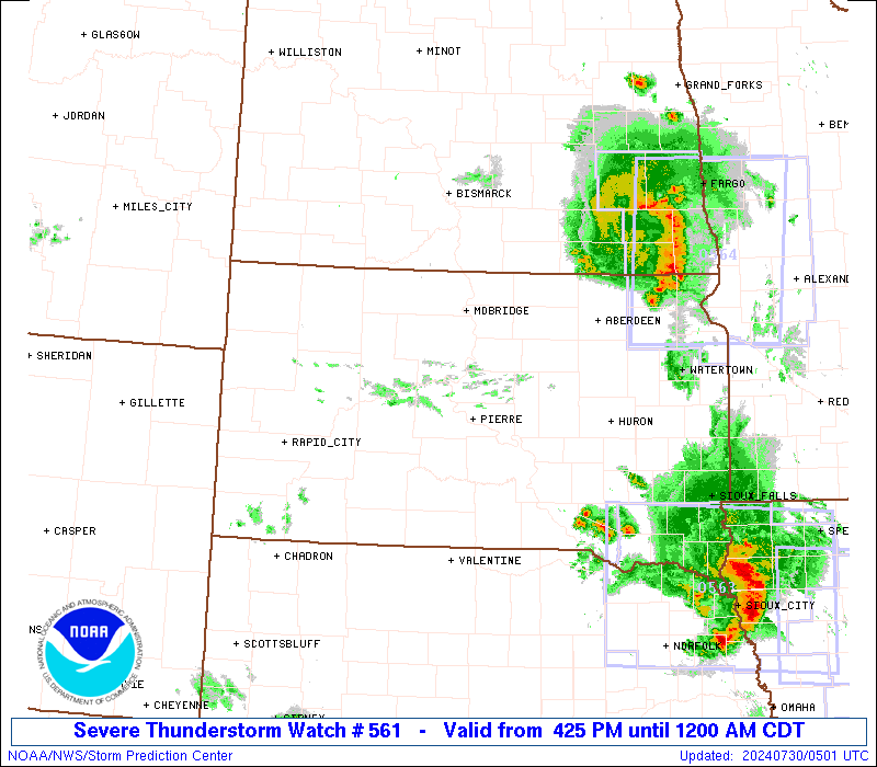
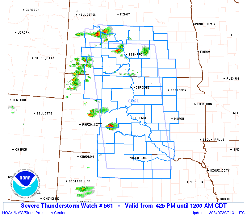
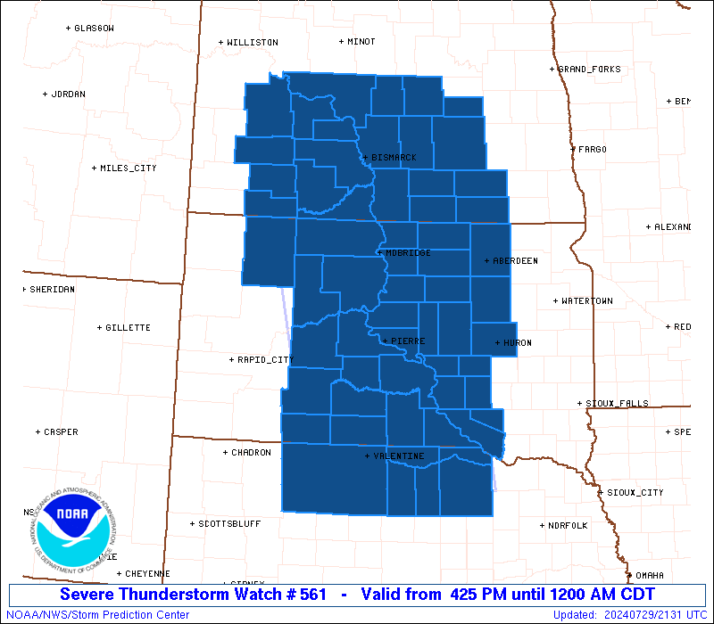
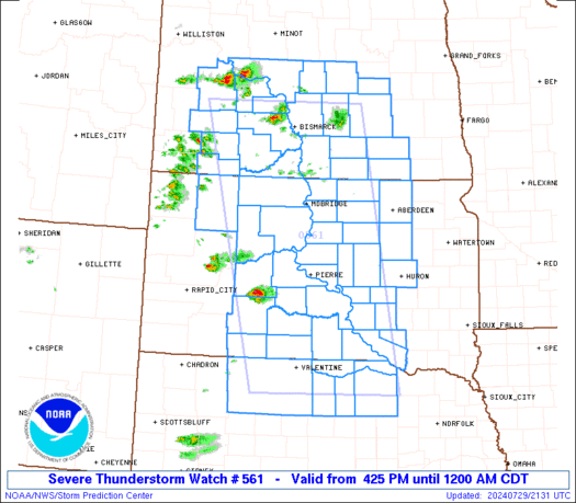
Severe Thunderstorm Watch Number 561
NWS Storm Prediction Center Norman OK
425 PM CDT Mon Jul 29 2024
The NWS Storm Prediction Center has issued a
* Severe Thunderstorm Watch for portions of
Central North Dakota
Northern Nebraska
Central South Dakota
* Effective this Monday afternoon from 425 PM until Midnight CDT.
* Primary threats include...
Scattered damaging winds and isolated significant gusts to 75
mph likely
Scattered large hail and isolated very large hail events to 2
inches in diameter likely
SUMMARY...Thunderstorms will develop and intensify across the watch
area through the late afternoon and evening hours, with initial
cells capable of large hail and locally damaging winds. The
potential exists for more widespread wind damage potential by mid
evening as storm clusters organize.
The severe thunderstorm watch area is approximately along and 85
statute miles east and west of a line from 30 miles north northwest
of Bismarck ND to 10 miles south southeast of Ainsworth NE. For a
complete depiction of the watch see the associated watch outline
update (WOUS64 KWNS WOU1).
PRECAUTIONARY/PREPAREDNESS ACTIONS...
REMEMBER...A Severe Thunderstorm Watch means conditions are
favorable for severe thunderstorms in and close to the watch area.
Persons in these areas should be on the lookout for threatening
weather conditions and listen for later statements and possible
warnings. Severe thunderstorms can and occasionally do produce
tornadoes.
&&
AVIATION...A few severe thunderstorms with hail surface and aloft to
2 inches. Extreme turbulence and surface wind gusts to 65 knots. A
few cumulonimbi with maximum tops to 500. Mean storm motion vector
28030.
...Hart
   SEL1

   URGENT - IMMEDIATE BROADCAST REQUESTED
   Severe Thunderstorm Watch Number 561
   NWS Storm Prediction Center Norman OK
   425 PM CDT Mon Jul 29 2024

   The NWS Storm Prediction Center has issued a

   * Severe Thunderstorm Watch for portions of
     Central North Dakota
     Northern Nebraska
     Central South Dakota

   * Effective this Monday afternoon from 425 PM until Midnight CDT.

   * Primary threats include...
     Scattered damaging winds and isolated significant gusts to 75
       mph likely
     Scattered large hail and isolated very large hail events to 2
       inches in diameter likely

   SUMMARY...Thunderstorms will develop and intensify across the watch
   area through the late afternoon and evening hours, with initial
   cells capable of large hail and locally damaging winds.  The
   potential exists for more widespread wind damage potential by mid
   evening as storm clusters organize.

   The severe thunderstorm watch area is approximately along and 85
   statute miles east and west of a line from 30 miles north northwest
   of Bismarck ND to 10 miles south southeast of Ainsworth NE. For a
   complete depiction of the watch see the associated watch outline
   update (WOUS64 KWNS WOU1).

   PRECAUTIONARY/PREPAREDNESS ACTIONS...

   REMEMBER...A Severe Thunderstorm Watch means conditions are
   favorable for severe thunderstorms in and close to the watch area.
   Persons in these areas should be on the lookout for threatening
   weather conditions and listen for later statements and possible
   warnings. Severe thunderstorms can and occasionally do produce
   tornadoes.

   &&

   AVIATION...A few severe thunderstorms with hail surface and aloft to
   2 inches. Extreme turbulence and surface wind gusts to 65 knots. A
   few cumulonimbi with maximum tops to 500. Mean storm motion vector
   28030.

   ...Hart
 Note:
The Aviation Watch (SAW) product is an approximation to the watch area.
The actual watch is depicted by the shaded areas.
Note:
The Aviation Watch (SAW) product is an approximation to the watch area.
The actual watch is depicted by the shaded areas.
SAW1
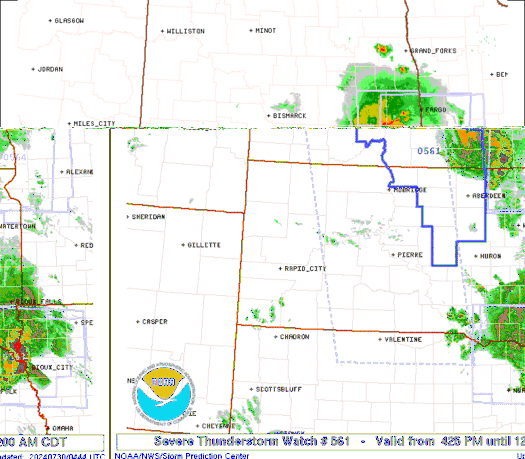
WW 561 SEVERE TSTM ND NE SD 292125Z - 300500Z
AXIS..85 STATUTE MILES EAST AND WEST OF LINE..
30NNW BIS/BISMARCK ND/ - 10SSE ANW/AINSWORTH NE/
..AVIATION COORDS.. 75NM E/W /28NNW BIS - 8SSE ANW/
HAIL SURFACE AND ALOFT..2 INCHES. WIND GUSTS..65 KNOTS.
MAX TOPS TO 500. MEAN STORM MOTION VECTOR 28030.
LAT...LON 47179918 42439824 42430157 47170280
THIS IS AN APPROXIMATION TO THE WATCH AREA. FOR A
COMPLETE DEPICTION OF THE WATCH SEE WOUS64 KWNS
FOR WOU1.
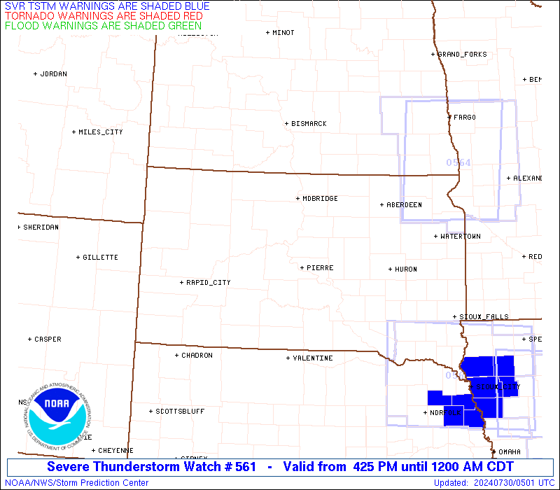
Watch 561 Status Report Messages:
STATUS REPORT #5 ON WW 561
VALID 300455Z - 300500Z
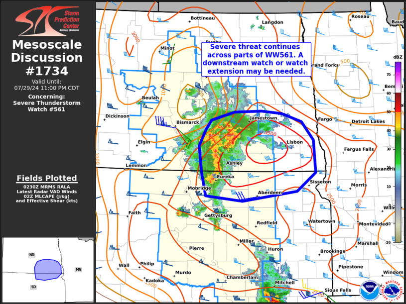
SEVERE WEATHER THREAT CONTINUES RIGHT OF A LINE FROM 10 ESE ONL
TO 30 SW ABR TO 45 SSW JMS TO 35 SSW JMS.
REMAINING VALID PORTION OF WW 561 MAY BE ALLOWED TO EXPIRE AT
30/05Z.
..KERR..07/30/24
ATTN...WFO...BIS...LBF...FSD...UNR...ABR...
&&
STATUS REPORT FOR WS 561
SEVERE WEATHER THREAT CONTINUES FOR THE FOLLOWING AREAS
NDC021-045-093-300500-
ND
. NORTH DAKOTA COUNTIES INCLUDED ARE
DICKEY LAMOURE STUTSMAN
$$
SDC013-115-300500-
SD
. SOUTH DAKOTA COUNTIES INCLUDED ARE
BROWN SPINK
$$
THE WATCH STATUS MESSAGE IS FOR GUIDANCE PURPOSES ONLY. PLEASE
REFER TO WATCH COUNTY NOTIFICATION STATEMENTS FOR OFFICIAL
INFORMATION ON COUNTIES...INDEPENDENT CITIES AND MARINE ZONES
CLEARED FROM SEVERE THUNDERSTORM AND TORNADO WATCHES.
$$
STATUS REPORT #4 ON WW 561
VALID 300330Z - 300440Z
SEVERE WEATHER THREAT CONTINUES RIGHT OF A LINE FROM 10 W ONL TO
45 SW MHE TO 35 SSW MHE TO 30 SW ABR TO 55 NW ABR TO 30 NW JMS.
..KERR..07/30/24
ATTN...WFO...BIS...LBF...FSD...UNR...ABR...
&&
STATUS REPORT FOR WS 561
SEVERE WEATHER THREAT CONTINUES FOR THE FOLLOWING AREAS
NEC015-089-300440-
NE
. NEBRASKA COUNTIES INCLUDED ARE
BOYD HOLT
$$
NDC021-031-045-047-051-093-300440-
ND
. NORTH DAKOTA COUNTIES INCLUDED ARE
DICKEY FOSTER LAMOURE
LOGAN MCINTOSH STUTSMAN
$$
SDC005-013-043-045-049-089-115-300440-
SD
. SOUTH DAKOTA COUNTIES INCLUDED ARE
BEADLE BROWN DOUGLAS
EDMUNDS FAULK MCPHERSON
SPINK
$$
THE WATCH STATUS MESSAGE IS FOR GUIDANCE PURPOSES ONLY. PLEASE
REFER TO WATCH COUNTY NOTIFICATION STATEMENTS FOR OFFICIAL
INFORMATION ON COUNTIES...INDEPENDENT CITIES AND MARINE ZONES
CLEARED FROM SEVERE THUNDERSTORM AND TORNADO WATCHES.
$$
STATUS REPORT #3 ON WW 561
VALID 300240Z - 300340Z
SEVERE WEATHER THREAT CONTINUES RIGHT OF A LINE FROM 15 NE MHN TO
25 WSW MHE TO 25 NNE MBG TO 45 ESE MOT.
FOR ADDITIONAL INFORMATION SEE MESOSCALE DISCUSSION 1734
..WEINMAN..07/30/24
ATTN...WFO...BIS...LBF...FSD...UNR...ABR...
&&
STATUS REPORT FOR WS 561
SEVERE WEATHER THREAT CONTINUES FOR THE FOLLOWING AREAS
NEC015-017-089-103-149-300340-
NE
. NEBRASKA COUNTIES INCLUDED ARE
BOYD BROWN HOLT
KEYA PAHA ROCK
$$
NDC015-021-029-031-043-045-047-051-083-093-103-300340-
ND
. NORTH DAKOTA COUNTIES INCLUDED ARE
BURLEIGH DICKEY EMMONS
FOSTER KIDDER LAMOURE
LOGAN MCINTOSH SHERIDAN
STUTSMAN WELLS
$$
SDC003-005-013-021-023-043-045-049-053-059-073-089-115-300340-
SD
. SOUTH DAKOTA COUNTIES INCLUDED ARE
AURORA BEADLE BROWN
CAMPBELL CHARLES MIX DOUGLAS
EDMUNDS FAULK GREGORY
HAND JERAULD MCPHERSON
SPINK
$$
THE WATCH STATUS MESSAGE IS FOR GUIDANCE PURPOSES ONLY. PLEASE
REFER TO WATCH COUNTY NOTIFICATION STATEMENTS FOR OFFICIAL
INFORMATION ON COUNTIES...INDEPENDENT CITIES AND MARINE ZONES
CLEARED FROM SEVERE THUNDERSTORM AND TORNADO WATCHES.
$$
STATUS REPORT #2 ON WW 561
VALID 300105Z - 300240Z
SEVERE WEATHER THREAT CONTINUES RIGHT OF A LINE FROM 5 SE MHN TO
30 NE VTN TO 55 SSE Y22 TO 15 SSW MOT.
FOR ADDITIONAL INFORMATION SEE MESOSCALE DISCUSSION 1731
..WEINMAN..07/30/24
ATTN...WFO...BIS...LBF...FSD...UNR...ABR...
&&
STATUS REPORT FOR WS 561
SEVERE WEATHER THREAT CONTINUES FOR THE FOLLOWING AREAS
NEC015-017-089-103-149-300240-
NE
. NEBRASKA COUNTIES INCLUDED ARE
BOYD BROWN HOLT
KEYA PAHA ROCK
$$
NDC015-021-029-031-043-045-047-049-051-055-059-065-083-085-093-
101-103-300240-
ND
. NORTH DAKOTA COUNTIES INCLUDED ARE
BURLEIGH DICKEY EMMONS
FOSTER KIDDER LAMOURE
LOGAN MCHENRY MCINTOSH
MCLEAN MORTON OLIVER
SHERIDAN SIOUX STUTSMAN
WARD WELLS
$$
SDC003-005-013-015-017-021-023-031-041-043-045-049-053-059-065-
069-073-085-089-107-115-119-123-129-137-300240-
SD
. SOUTH DAKOTA COUNTIES INCLUDED ARE
AURORA BEADLE BROWN
BRULE BUFFALO CAMPBELL
CHARLES MIX CORSON DEWEY
DOUGLAS EDMUNDS FAULK
GREGORY HAND HUGHES
HYDE JERAULD LYMAN
MCPHERSON POTTER SPINK
SULLY TRIPP WALWORTH
ZIEBACH
$$
THE WATCH STATUS MESSAGE IS FOR GUIDANCE PURPOSES ONLY. PLEASE
REFER TO WATCH COUNTY NOTIFICATION STATEMENTS FOR OFFICIAL
INFORMATION ON COUNTIES...INDEPENDENT CITIES AND MARINE ZONES
CLEARED FROM SEVERE THUNDERSTORM AND TORNADO WATCHES.
$$
STATUS REPORT #1 ON WW 561
VALID 300000Z - 300140Z
SEVERE WEATHER THREAT CONTINUES RIGHT OF A LINE FROM 10 ESE MHN
TO 40 NNE PHP TO 60 S Y22 TO 25 NW N60.
FOR ADDITIONAL INFORMATION SEE MESOSCALE DISCUSSION 1731
..WEINMAN..07/29/24
ATTN...WFO...BIS...LBF...FSD...UNR...ABR...
&&
STATUS REPORT FOR WS 561
SEVERE WEATHER THREAT CONTINUES FOR THE FOLLOWING AREAS
NEC015-017-031-089-103-149-300140-
NE
. NEBRASKA COUNTIES INCLUDED ARE
BOYD BROWN CHERRY
HOLT KEYA PAHA ROCK
$$
NDC015-021-029-031-037-043-045-047-049-051-055-057-059-065-083-
085-093-101-103-300140-
ND
. NORTH DAKOTA COUNTIES INCLUDED ARE
BURLEIGH DICKEY EMMONS
FOSTER GRANT KIDDER
LAMOURE LOGAN MCHENRY
MCINTOSH MCLEAN MERCER
MORTON OLIVER SHERIDAN
SIOUX STUTSMAN WARD
WELLS
$$
SDC003-005-013-015-017-021-023-031-041-043-045-049-053-055-059-
065-069-073-075-085-089-095-105-107-115-117-119-121-123-129-137-
300140-
SD
. SOUTH DAKOTA COUNTIES INCLUDED ARE
AURORA BEADLE BROWN
BRULE BUFFALO CAMPBELL
CHARLES MIX CORSON DEWEY
DOUGLAS EDMUNDS FAULK
GREGORY HAAKON HAND
HUGHES HYDE JERAULD
JONES LYMAN MCPHERSON
MELLETTE PERKINS POTTER
SPINK STANLEY SULLY
TODD TRIPP WALWORTH
ZIEBACH
$$
THE WATCH STATUS MESSAGE IS FOR GUIDANCE PURPOSES ONLY. PLEASE
REFER TO WATCH COUNTY NOTIFICATION STATEMENTS FOR OFFICIAL
INFORMATION ON COUNTIES...INDEPENDENT CITIES AND MARINE ZONES
CLEARED FROM SEVERE THUNDERSTORM AND TORNADO WATCHES.
$$
Note:
Click for Complete Product Text.
Tornadoes
Probability of 2 or more tornadoes
|
Low (10%)
|
Probability of 1 or more strong (EF2-EF5) tornadoes
|
Low (<2%)
|
Wind
Probability of 10 or more severe wind events
|
High (70%)
|
Probability of 1 or more wind events > 65 knots
|
Mod (60%)
|
Hail
Probability of 10 or more severe hail events
|
Mod (60%)
|
Probability of 1 or more hailstones > 2 inches
|
Mod (60%)
|
Combined Severe Hail/Wind
Probability of 6 or more combined severe hail/wind events
|
High (>95%)
|
For each watch, probabilities for particular events inside the watch
(listed above in each table) are determined by the issuing forecaster.
The "Low" category contains probability values ranging from less than 2%
to 20% (EF2-EF5 tornadoes), less than 5% to 20% (all other probabilities),
"Moderate" from 30% to 60%, and "High" from 70% to greater than 95%.
High values are bolded and lighter in color to provide awareness of
an increased threat for a particular event.


 @NWSSPC