|
| Mesoscale Discussion 1734 |
|
< Previous MD Next MD >
|

|
   Mesoscale Discussion 1734
   NWS Storm Prediction Center Norman OK
   0933 PM CDT Mon Jul 29 2024

   Areas affected...Parts of southeastern North Dakota and northeastern
   South Dakota

   Concerning...Severe Thunderstorm Watch 561...

   Valid 300233Z - 300400Z

   The severe weather threat for Severe Thunderstorm Watch 561
   continues.

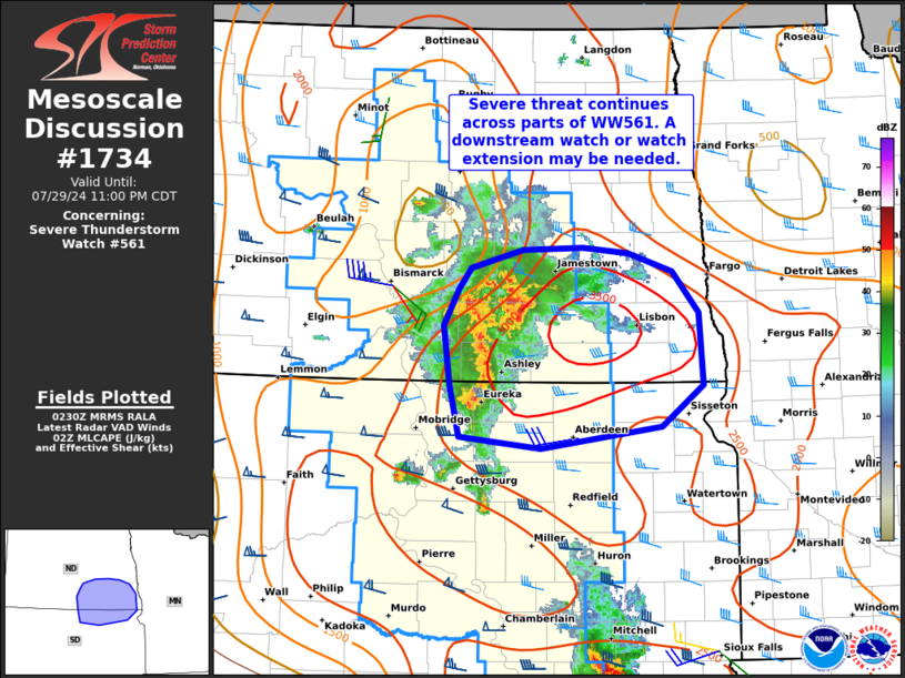
   SUMMARY...The severe threat continues across portions of
   southern/southeastern North Dakota and northern/northeastern South
   Dakota in Severe Thunderstorm Watch 561. The severe threat may
   spread eastward out of the watch, and a new watch or watch extension
   may be needed.

   DISCUSSION...An increasingly organized north/south-oriented MCS is
   tracking eastward across south-central ND and north-central SD at
   around 30-40 kt, while an additional cluster of storms to its east
   is drifting slowly northward within a warm-advection wing. The MCS
   is gradually merging/overtaking the eastern cluster. Ahead of these
   storms, 2500-3000 J/kg MLCAPE (sampled by the ABR 00Z sounding) will
   likely support the maintenance of this activity as it continues
   eastward. Additionally, the ABR 00Z sounding and recent KBIS VWP
   data indicate a long/straight hodograph -- characterized by around
   40 kt of westerly deep-layer shear. The combination of the favorable
   instability and shear vectors oriented perpendicular to the
   leading-edge gust front, should favor a continued organized/linear
   mode. Severe wind gusts to around 75 mph will be the primary
   concern.

   A downstream watch or watch extension may be needed.

   ..Weinman.. 07/30/2024

   ...Please see www.spc.noaa.gov for graphic product...

   ATTN...WFO...FGF...ABR...BIS...

   LAT...LON   45900001 46420010 46749990 46929975 47099910 47109835
               47059778 46909722 46549689 45909685 45559737 45369888
               45469989 45900001
|
|
Top/All Mesoscale Discussions/Forecast Products/Home
|
|


