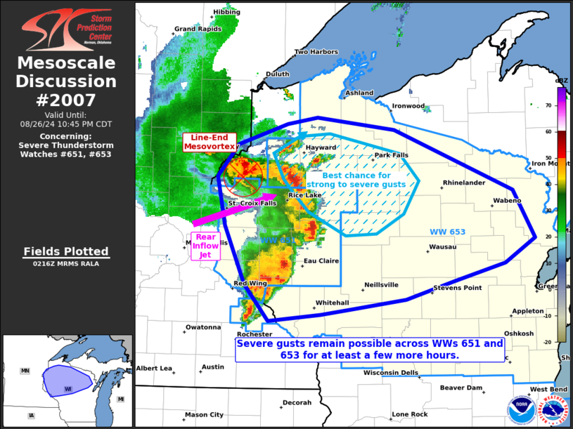
   Mesoscale Discussion 2007
   NWS Storm Prediction Center Norman OK
   0919 PM CDT Mon Aug 26 2024

   Areas affected...portions of western into central Wisconsin

   Concerning...Severe Thunderstorm Watch 651...653...

   Valid 270219Z - 270345Z

   The severe weather threat for Severe Thunderstorm Watch 651, 653
   continues.

   SUMMARY...The severe threat continues across the remainder of Severe
   Thunderstorm Watch 651 into 653. Severe gusts are the main threat,
   with the best chances of severe gusts likely around the northern
   portions of the bow echo MCS.

   DISCUSSION...Several damage reports have been received in
   conjunction with an east-northeast propagating bow echo MCS over the
   past few hours, along with ASOS measurements in the 45-55 kt range.
   This bow echo will continue to traverse a diffuse baroclinic zone,
   riding a gradient of strong instability (i.e. 3000-4500 J/kg
   MLCAPE), where MLCINH remains minimal. On the northern end of this
   cyclonic bow echo MCS is a line-end mesovortex, where the most
   recent wind damage reports have been received, and where
   regional-radar cross-section analyses depicts the presence of a
   rear-inflow jet. As such, damaging gusts should continue in this
   regime for at least a few more hours, with some strong/damaging wind
   gusts also possible farther south along the line.

   ..Squitieri.. 08/27/2024

   ...Please see www.spc.noaa.gov for graphic product...

   ATTN...WFO...GRB...DLH...ARX...MPX...

   LAT...LON   44289121 44229199 44609235 45239265 45749277 46099246
               46309172 46379127 46259012 45598833 45098802 44838847
               44638923 44458994 44359074 44289121
|


 @NWSSPC