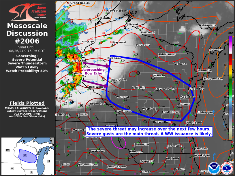
   Mesoscale Discussion 2006
   NWS Storm Prediction Center Norman OK
   0751 PM CDT Mon Aug 26 2024

   Areas affected...much of central Wisconsin

   Concerning...Severe potential...Severe Thunderstorm Watch likely

   Valid 270051Z - 270215Z

   Probability of Watch Issuance...80 percent

   SUMMARY...The severe threat is increasing across much of central
   Wisconsin as a damaging-wind-producing MCS approaches the region. A
   Severe Thunderstorm Watch may be needed in the next hour or so.

   DISCUSSION...A well-developed, mature MCS with bowing tendencies and
   a recent history of severe gusts, is approaching western Wisconsin,
   east of Severe Thunderstorm Watch 651. Preceding the bowing MCS is a
   corridor of strong to extreme MLCAPE (i.e. 4500-5000 J/kg) and
   minimal MLCINH. However, vertical wind shear (especially in the low
   levels) is not particularly strong, which is what is typically
   needed for intense bow echo wind swaths. Furthermore, while surface
   temperatures are around 90 F in spots, sunset is approaching, which
   will support nocturnal cooling and an eventual increase in MLCINH.
   On balance, at least some risk for continued severe gusts should
   continue for at least a few more hours as the MCS exceeds the
   eastern bounds of Severe Thunderstorm Watch 651. As such, a
   downstream severe thunderstorm watch will likely be needed in the
   next hour or so.

   ..Squitieri/Gleason.. 08/27/2024

   ...Please see www.spc.noaa.gov for graphic product...

   ATTN...WFO...GRB...MKX...DLH...ARX...MPX...

   LAT...LON   45649155 45549035 45168903 44678795 44228777 43848800
               43548837 43588914 43678987 43859058 44009113 44169151
               44359171 44569172 45649155
|


 @NWSSPC