 Note:
The expiration time in the watch graphic is amended if the watch is
replaced, cancelled or extended.
Note:
Note:
The expiration time in the watch graphic is amended if the watch is
replaced, cancelled or extended.
Note: Click for
Watch Status Reports.
SEL8
URGENT - IMMEDIATE BROADCAST REQUESTED
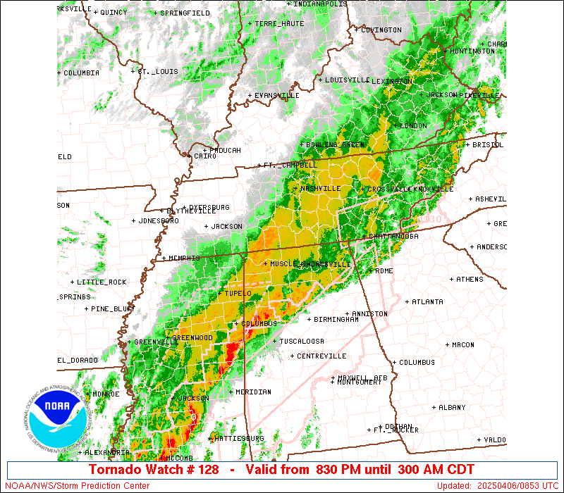
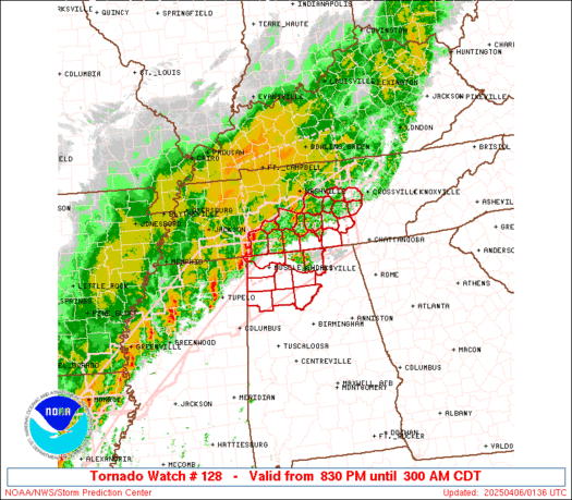
Tornado Watch Number 128
NWS Storm Prediction Center Norman OK
830 PM CDT Sat Apr 5 2025
The NWS Storm Prediction Center has issued a
* Tornado Watch for portions of
Northern Alabama
Southern Middle Tennessee
* Effective this Saturday night and Sunday morning from 830 PM
until 300 AM CDT.
* Primary threats include...
A few tornadoes likely with a couple intense tornadoes possible
Scattered damaging winds likely with isolated significant gusts
to 75 mph possible
Isolated large hail events to 1.5 inches in diameter possible
SUMMARY...A cluster of supercell thunderstorms over northeast
Mississippi will track across the watch area with a continued risk
of tornadoes and damaging winds. Other strong to severe storms will
also move across the watch area through the early morning hours.
The tornado watch area is approximately along and 55 statute miles
north and south of a line from 35 miles west southwest of Muscle
Shoals AL to 105 miles northeast of Huntsville AL. For a complete
depiction of the watch see the associated watch outline update
(WOUS64 KWNS WOU8).
PRECAUTIONARY/PREPAREDNESS ACTIONS...
REMEMBER...A Tornado Watch means conditions are favorable for
tornadoes and severe thunderstorms in and close to the watch
area. Persons in these areas should be on the lookout for
threatening weather conditions and listen for later statements
and possible warnings.
&&
OTHER WATCH INFORMATION...CONTINUE...WW 123...WW 124...WW
125...WW 126...WW 127...
AVIATION...Tornadoes and a few severe thunderstorms with hail
surface and aloft to 1.5 inches. Extreme turbulence and surface wind
gusts to 65 knots. A few cumulonimbi with maximum tops to 500. Mean
storm motion vector 24035.
...Hart
 Note:
The Aviation Watch (SAW) product is an approximation to the watch area.
The actual watch is depicted by the shaded areas.
Note:
The Aviation Watch (SAW) product is an approximation to the watch area.
The actual watch is depicted by the shaded areas.
   SAW8
   WW 128 TORNADO AL TN 060130Z - 060800Z
   AXIS..55 STATUTE MILES NORTH AND SOUTH OF LINE..
   35WSW MSL/MUSCLE SHOALS AL/ - 105NE HSV/HUNTSVILLE AL/
   ..AVIATION COORDS.. 50NM N/S /36WSW MSL - 48NNW GQO/
   HAIL SURFACE AND ALOFT..1.5 INCHES. WIND GUSTS..65 KNOTS.
   MAX TOPS TO 500. MEAN STORM MOTION VECTOR 24035.

   LAT...LON 35348819 36508546 34918546 33758819

   THIS IS AN APPROXIMATION TO THE WATCH AREA.  FOR A
   COMPLETE DEPICTION OF THE WATCH SEE WOUS64 KWNS
   FOR WOU8.
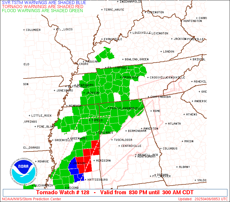
Watch 128 Status Report Messages:
STATUS REPORT #4 ON WW 128

VALID 060650Z - 060740Z

SEVERE WEATHER THREAT CONTINUES RIGHT OF A LINE FROM 20 NE CBM TO
25 SE MSL TO 15 WSW CHA.

..KERR..04/06/25

ATTN...WFO...HUN...BMX...OHX...

&&

STATUS REPORT FOR WT 128

SEVERE WEATHER THREAT CONTINUES FOR THE FOLLOWING AREAS

ALC043-049-057-071-075-089-093-095-103-107-127-133-060740-

AL
.    ALABAMA COUNTIES INCLUDED ARE

CULLMAN 	     DEKALB		 FAYETTE
JACKSON 	     LAMAR		 MADISON
MARION		     MARSHALL		 MORGAN
PICKENS 	     WALKER		 WINSTON
$$


THE WATCH STATUS MESSAGE IS FOR GUIDANCE PURPOSES ONLY.  PLEASE
REFER TO WATCH COUNTY NOTIFICATION STATEMENTS FOR OFFICIAL
INFORMATION ON COUNTIES...INDEPENDENT CITIES AND MARINE ZONES
CLEARED FROM SEVERE THUNDERSTORM AND TORNADO WATCHES.
$$

STATUS REPORT #3 ON WW 128

VALID 060545Z - 060640Z

SEVERE WEATHER THREAT CONTINUES RIGHT OF A LINE FROM 30 SSW MSL
TO 40 N HSV TO 25 WNW CSV.

..KERR..04/06/25

ATTN...WFO...HUN...BMX...OHX...

&&

STATUS REPORT FOR WT 128

SEVERE WEATHER THREAT CONTINUES FOR THE FOLLOWING AREAS

ALC043-057-075-079-083-089-093-103-107-127-133-060640-

AL
.    ALABAMA COUNTIES INCLUDED ARE

CULLMAN 	     FAYETTE		 LAMAR
LAWRENCE	     LIMESTONE		 MADISON
MARION		     MORGAN		 PICKENS
WALKER		     WINSTON
$$


TNC031-035-051-061-103-127-175-060640-

TN
.    TENNESSEE COUNTIES INCLUDED ARE

COFFEE		     CUMBERLAND 	 FRANKLIN
GRUNDY		     LINCOLN		 MOORE
VAN BUREN
$$


THE WATCH STATUS MESSAGE IS FOR GUIDANCE PURPOSES ONLY.  PLEASE
REFER TO WATCH COUNTY NOTIFICATION STATEMENTS FOR OFFICIAL
INFORMATION ON COUNTIES...INDEPENDENT CITIES AND MARINE ZONES
CLEARED FROM SEVERE THUNDERSTORM AND TORNADO WATCHES.
$$

STATUS REPORT #2 ON WW 128

VALID 060410Z - 060540Z

SEVERE WEATHER THREAT CONTINUES RIGHT OF A LINE FROM 45 WNW MSL
TO 55 SW BNA TO 15 ENE BNA.

..DEAN..04/06/25

ATTN...WFO...HUN...BMX...OHX...

&&

STATUS REPORT FOR WT 128

SEVERE WEATHER THREAT CONTINUES FOR THE FOLLOWING AREAS

ALC033-043-059-077-079-083-089-093-103-133-060540-

AL
.    ALABAMA COUNTIES INCLUDED ARE

COLBERT 	     CULLMAN		 FRANKLIN
LAUDERDALE	     LAWRENCE		 LIMESTONE
MADISON 	     MARION		 MORGAN
WINSTON
$$


TNC003-015-031-041-051-055-061-099-101-103-117-119-127-149-175-
177-181-185-060540-

TN
.    TENNESSEE COUNTIES INCLUDED ARE

BEDFORD 	     CANNON		 COFFEE
DE KALB 	     FRANKLIN		 GILES
GRUNDY		     LAWRENCE		 LEWIS
LINCOLN 	     MARSHALL		 MAURY
MOORE		     RUTHERFORD 	 VAN BUREN
WARREN		     WAYNE		 WHITE
$$


THE WATCH STATUS MESSAGE IS FOR GUIDANCE PURPOSES ONLY.  PLEASE
REFER TO WATCH COUNTY NOTIFICATION STATEMENTS FOR OFFICIAL
INFORMATION ON COUNTIES...INDEPENDENT CITIES AND MARINE ZONES
CLEARED FROM SEVERE THUNDERSTORM AND TORNADO WATCHES.
$$

STATUS REPORT #1 ON WW 128

VALID 060215Z - 060340Z

THE SEVERE WEATHER THREAT CONTINUES ACROSS THE ENTIRE WATCH AREA.

..DEAN..04/06/25

ATTN...WFO...HUN...BMX...OHX...

&&

STATUS REPORT FOR WT 128

SEVERE WEATHER THREAT CONTINUES FOR THE FOLLOWING AREAS

ALC033-043-059-077-079-083-089-093-103-133-060340-

AL
.    ALABAMA COUNTIES INCLUDED ARE

COLBERT 	     CULLMAN		 FRANKLIN
LAUDERDALE	     LAWRENCE		 LIMESTONE
MADISON 	     MARION		 MORGAN
WINSTON
$$


TNC003-015-031-041-051-055-061-099-101-103-117-119-127-149-175-
177-181-185-060340-

TN
.    TENNESSEE COUNTIES INCLUDED ARE

BEDFORD 	     CANNON		 COFFEE
DE KALB 	     FRANKLIN		 GILES
GRUNDY		     LAWRENCE		 LEWIS
LINCOLN 	     MARSHALL		 MAURY
MOORE		     RUTHERFORD 	 VAN BUREN
WARREN		     WAYNE		 WHITE
$$


THE WATCH STATUS MESSAGE IS FOR GUIDANCE PURPOSES ONLY.  PLEASE
REFER TO WATCH COUNTY NOTIFICATION STATEMENTS FOR OFFICIAL
INFORMATION ON COUNTIES...INDEPENDENT CITIES AND MARINE ZONES
CLEARED FROM SEVERE THUNDERSTORM AND TORNADO WATCHES.
$$
Note:
Click for Complete Product Text.
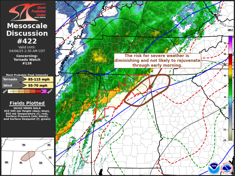
Tornadoes
Probability of 2 or more tornadoes
|
High (70%)
|
Probability of 1 or more strong (EF2-EF5) tornadoes
|
Mod (40%)
|
Wind
Probability of 10 or more severe wind events
|
Mod (60%)
|
Probability of 1 or more wind events > 65 knots
|
Mod (30%)
|
Hail
Probability of 10 or more severe hail events
|
Mod (30%)
|
Probability of 1 or more hailstones > 2 inches
|
Low (20%)
|
Combined Severe Hail/Wind
Probability of 6 or more combined severe hail/wind events
|
High (80%)
|
For each watch, probabilities for particular events inside the watch
(listed above in each table) are determined by the issuing forecaster.
The "Low" category contains probability values ranging from less than 2%
to 20% (EF2-EF5 tornadoes), less than 5% to 20% (all other probabilities),
"Moderate" from 30% to 60%, and "High" from 70% to greater than 95%.
High values are bolded and lighter in color to provide awareness of
an increased threat for a particular event.


 @NWSSPC