|
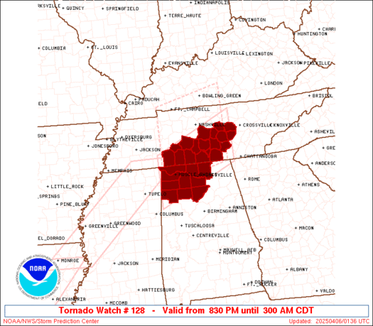
Initial List of Counties in SPC Tornado Watch 128 (WOU)
|
Back to Watch 128
|
 |
   WOUS64 KWNS 060128
   WOU8

   BULLETIN - IMMEDIATE BROADCAST REQUESTED
   TORNADO WATCH OUTLINE UPDATE FOR WT 128
   NWS STORM PREDICTION CENTER NORMAN OK
   830 PM CDT SAT APR 5 2025

   TORNADO WATCH 128 IS IN EFFECT UNTIL 300 AM CDT FOR THE
    FOLLOWING LOCATIONS

   ALC033-043-059-077-079-083-089-093-103-133-060800-
   /O.NEW.KWNS.TO.A.0128.250406T0130Z-250406T0800Z/

   AL
   .    ALABAMA COUNTIES INCLUDED ARE

   COLBERT              CULLMAN             FRANKLIN
   LAUDERDALE           LAWRENCE            LIMESTONE
   MADISON              MARION              MORGAN
   WINSTON


   TNC003-015-031-041-051-055-061-099-101-103-117-119-127-149-175-
   177-181-185-060800-
   /O.NEW.KWNS.TO.A.0128.250406T0130Z-250406T0800Z/

   TN
   .    TENNESSEE COUNTIES INCLUDED ARE

   BEDFORD              CANNON              COFFEE
   DE KALB              FRANKLIN            GILES
   GRUNDY               LAWRENCE            LEWIS
   LINCOLN              MARSHALL            MAURY
   MOORE                RUTHERFORD          VAN BUREN
   WARREN               WAYNE               WHITE


   ATTN...WFO...HUN...OHX...BMX...
|
| Aviation Watch (SAW) for WW128 |
|---|
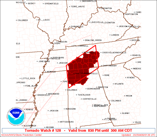 |
| Note:
The Aviation Watch (SAW) product is an approximation to the watch area.
The actual watch is depicted by the shaded areas. |
   SAW8
   WW 128 TORNADO AL TN 060130Z - 060800Z
   AXIS..55 STATUTE MILES NORTH AND SOUTH OF LINE..
   35WSW MSL/MUSCLE SHOALS AL/ - 105NE HSV/HUNTSVILLE AL/
   ..AVIATION COORDS.. 50NM N/S /36WSW MSL - 48NNW GQO/
   HAIL SURFACE AND ALOFT..1.5 INCHES. WIND GUSTS..65 KNOTS.
   MAX TOPS TO 500. MEAN STORM MOTION VECTOR 24035.

   LAT...LON 35348819 36508546 34918546 33758819

   THIS IS AN APPROXIMATION TO THE WATCH AREA.  FOR A
   COMPLETE DEPICTION OF THE WATCH SEE WOUS64 KWNS
   FOR WOU8.
|
|


 @NWSSPC
