Note:
The expiration time in the watch graphic is amended if the watch is
replaced, cancelled or extended.
Note:
Note:
The expiration time in the watch graphic is amended if the watch is
replaced, cancelled or extended.
Note: Click for
Watch Status Reports.
SEL4
URGENT - IMMEDIATE BROADCAST REQUESTED
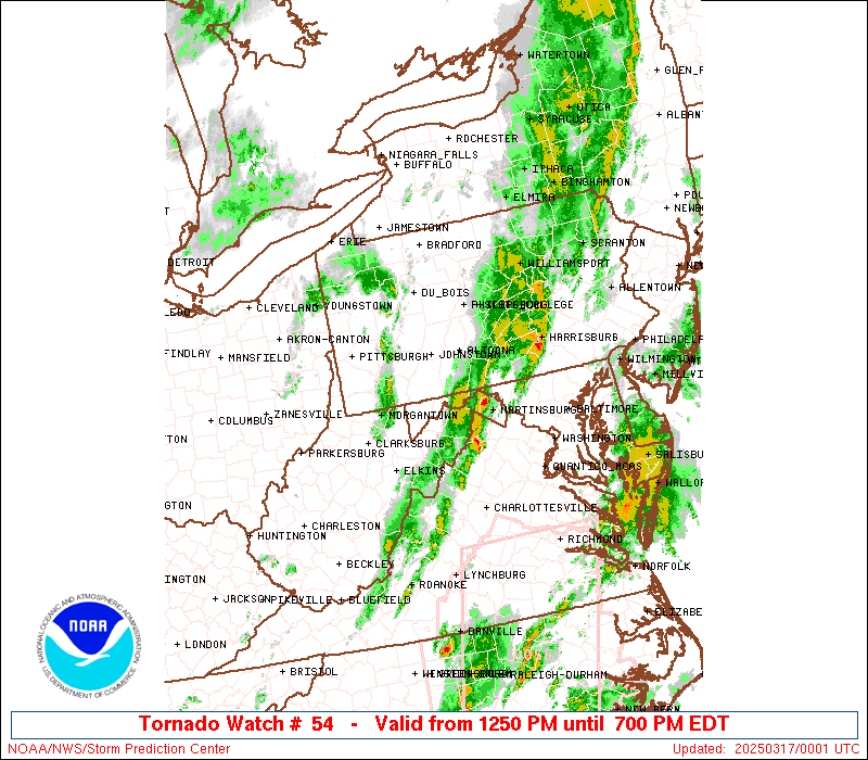
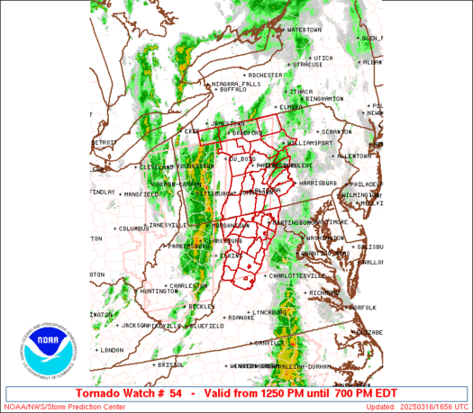
Tornado Watch Number 54
NWS Storm Prediction Center Norman OK
1250 PM EDT Sun Mar 16 2025
The NWS Storm Prediction Center has issued a
* Tornado Watch for portions of
Western Maryland
Western and Central Pennsylvania
Northern Virginia
Eastern West Virginia
* Effective this Sunday afternoon and evening from 1250 PM until
700 PM EDT.
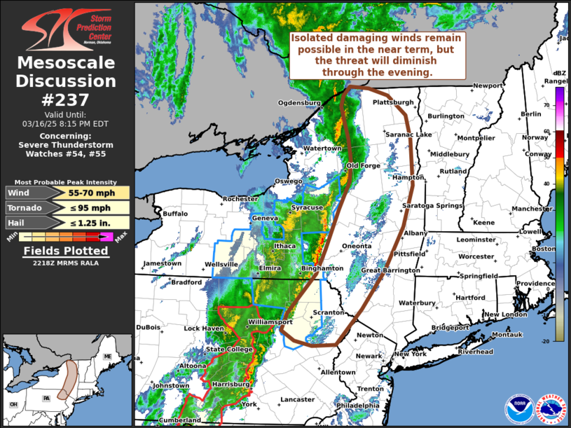
* Primary threats include...
A couple tornadoes possible
Scattered damaging wind gusts to 70 mph likely
SUMMARY...A line of thunderstorms will move quickly northeastward
this afternoon and evening, while posing a threat for mainly
damaging winds with peak gusts up to 60-70 mph. A couple of
line-embedded tornadoes may also occur.
The tornado watch area is approximately along and 40 statute miles
east and west of a line from 75 miles north of State College PA to
10 miles west southwest of Staunton VA. For a complete depiction of
the watch see the associated watch outline update (WOUS64 KWNS
WOU4).
PRECAUTIONARY/PREPAREDNESS ACTIONS...
REMEMBER...A Tornado Watch means conditions are favorable for
tornadoes and severe thunderstorms in and close to the watch
area. Persons in these areas should be on the lookout for
threatening weather conditions and listen for later statements
and possible warnings.
&&
OTHER WATCH INFORMATION...CONTINUE...WW 51...WW 52...WW 53...
AVIATION...Tornadoes and a few severe thunderstorms with hail
surface and aloft to 1 inch. Extreme turbulence and surface wind
gusts to 60 knots. A few cumulonimbi with maximum tops to 350. Mean
storm motion vector 22045.
...Gleason
   SEL4

   URGENT - IMMEDIATE BROADCAST REQUESTED
   Tornado Watch Number 54
   NWS Storm Prediction Center Norman OK
   1250 PM EDT Sun Mar 16 2025

   The NWS Storm Prediction Center has issued a

   * Tornado Watch for portions of
     Western Maryland
     Western and Central Pennsylvania
     Northern Virginia
     Eastern West Virginia

   * Effective this Sunday afternoon and evening from 1250 PM until
     700 PM EDT.

   * Primary threats include...
     A couple tornadoes possible
     Scattered damaging wind gusts to 70 mph likely

   SUMMARY...A line of thunderstorms will move quickly northeastward
   this afternoon and evening, while posing a threat for mainly
   damaging winds with peak gusts up to 60-70 mph. A couple of
   line-embedded tornadoes may also occur.

   The tornado watch area is approximately along and 40 statute miles
   east and west of a line from 75 miles north of State College PA to
   10 miles west southwest of Staunton VA. For a complete depiction of
   the watch see the associated watch outline update (WOUS64 KWNS
   WOU4).

   PRECAUTIONARY/PREPAREDNESS ACTIONS...

   REMEMBER...A Tornado Watch means conditions are favorable for
   tornadoes and severe thunderstorms in and close to the watch
   area. Persons in these areas should be on the lookout for
   threatening weather conditions and listen for later statements
   and possible warnings.

   &&

   OTHER WATCH INFORMATION...CONTINUE...WW 51...WW 52...WW 53...

   AVIATION...Tornadoes and a few severe thunderstorms with hail
   surface and aloft to 1 inch. Extreme turbulence and surface wind
   gusts to 60 knots. A few cumulonimbi with maximum tops to 350. Mean
   storm motion vector 22045.

   ...Gleason
 Note:
The Aviation Watch (SAW) product is an approximation to the watch area.
The actual watch is depicted by the shaded areas.
Note:
The Aviation Watch (SAW) product is an approximation to the watch area.
The actual watch is depicted by the shaded areas.
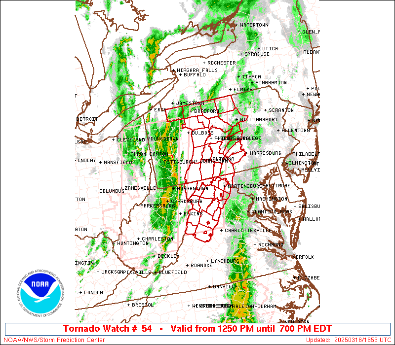
   SAW4
   WW 54 TORNADO MD PA VA WV 161650Z - 162300Z
   AXIS..40 STATUTE MILES EAST AND WEST OF LINE..
   75N UNV/STATE COLLEGE PA/ - 10WSW SHD/STAUNTON VA/
   ..AVIATION COORDS.. 35NM E/W /26NNE SLT - 58N LYH/
   HAIL SURFACE AND ALOFT..1 INCH. WIND GUSTS..60 KNOTS.
   MAX TOPS TO 350. MEAN STORM MOTION VECTOR 22045.

   LAT...LON 41937707 38217833 38217981 41937862

   THIS IS AN APPROXIMATION TO THE WATCH AREA.  FOR A
   COMPLETE DEPICTION OF THE WATCH SEE WOUS64 KWNS
   FOR WOU4.
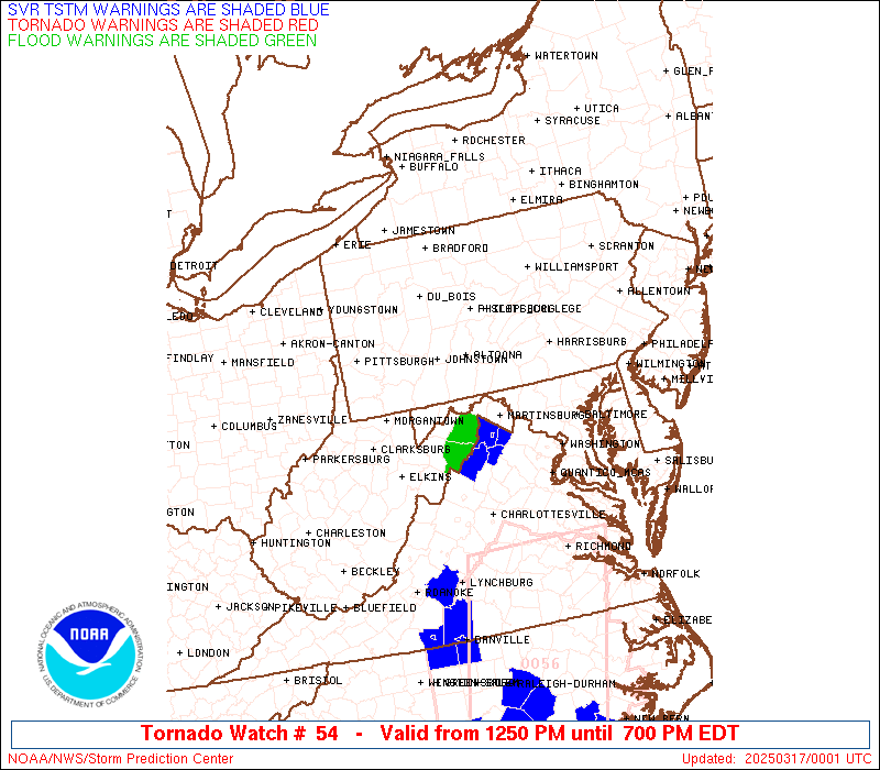
Watch 54 Status Report Messages:
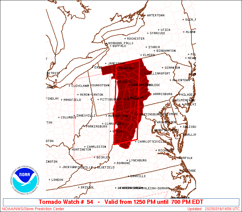
STATUS REPORT #3 ON WW 54

VALID 162300Z - 170040Z

SEVERE WEATHER THREAT CONTINUES RIGHT OF A LINE FROM 40 ENE SSU
TO 20 SE AOO TO 30 NNW CXY TO 30 NNE IPT.

..MOORE..03/16/25

ATTN...WFO...LWX...CTP...

&&

STATUS REPORT FOR WT 54

SEVERE WEATHER THREAT CONTINUES FOR THE FOLLOWING AREAS

MDC043-170040-

MD
.    MARYLAND COUNTIES INCLUDED ARE

WASHINGTON
$$


PAC041-055-057-099-170040-

PA
.    PENNSYLVANIA COUNTIES INCLUDED ARE

CUMBERLAND	     FRANKLIN		 FULTON
PERRY
$$


VAC015-043-069-139-165-171-187-660-790-820-840-170040-

VA
.    VIRGINIA COUNTIES INCLUDED ARE

AUGUSTA 	     CLARKE		 FREDERICK
PAGE		     ROCKINGHAM 	 SHENANDOAH
WARREN


VIRGINIA INDEPENDENT CITIES INCLUDED ARE

HARRISONBURG	     STAUNTON		 WAYNESBORO
WINCHESTER
$$


WVC003-037-065-170040-

WV
.    WEST VIRGINIA COUNTIES INCLUDED ARE

BERKELEY	     JEFFERSON		 MORGAN
$$


THE WATCH STATUS MESSAGE IS FOR GUIDANCE PURPOSES ONLY.  PLEASE
REFER TO WATCH COUNTY NOTIFICATION STATEMENTS FOR OFFICIAL
INFORMATION ON COUNTIES...INDEPENDENT CITIES AND MARINE ZONES
CLEARED FROM SEVERE THUNDERSTORM AND TORNADO WATCHES.
$$

STATUS REPORT #2 ON WW 54

VALID 161950Z - 162040Z

SEVERE WEATHER THREAT CONTINUES RIGHT OF A LINE FROM 40 NE SSU TO
40 ENE EKN TO 35 S AOO TO 25 ENE AOO TO 25 ENE UNV TO 30 NW IPT
TO 30 WNW ELM.

..BENTLEY..03/16/25

ATTN...WFO...LWX...CTP...

&&

STATUS REPORT FOR WT 54

SEVERE WEATHER THREAT CONTINUES FOR THE FOLLOWING AREAS

MDC001-043-162040-

MD
.    MARYLAND COUNTIES INCLUDED ARE

ALLEGANY	     WASHINGTON
$$


PAC041-055-057-061-067-081-087-099-109-117-119-162040-

PA
.    PENNSYLVANIA COUNTIES INCLUDED ARE

CUMBERLAND	     FRANKLIN		 FULTON
HUNTINGDON	     JUNIATA		 LYCOMING
MIFFLIN 	     PERRY		 SNYDER
TIOGA		     UNION
$$


VAC015-043-069-091-139-165-171-187-660-790-820-840-162040-

VA
.    VIRGINIA COUNTIES INCLUDED ARE

AUGUSTA 	     CLARKE		 FREDERICK
HIGHLAND	     PAGE		 ROCKINGHAM
SHENANDOAH	     WARREN


VIRGINIA INDEPENDENT CITIES INCLUDED ARE

HARRISONBURG	     STAUNTON		 WAYNESBORO
WINCHESTER
$$


WVC003-023-027-031-037-057-065-071-162040-

WV
.    WEST VIRGINIA COUNTIES INCLUDED ARE

BERKELEY	     GRANT		 HAMPSHIRE
HARDY		     JEFFERSON		 MINERAL
MORGAN		     PENDLETON
$$


THE WATCH STATUS MESSAGE IS FOR GUIDANCE PURPOSES ONLY.  PLEASE
REFER TO WATCH COUNTY NOTIFICATION STATEMENTS FOR OFFICIAL
INFORMATION ON COUNTIES...INDEPENDENT CITIES AND MARINE ZONES
CLEARED FROM SEVERE THUNDERSTORM AND TORNADO WATCHES.
$$

STATUS REPORT #1 ON WW 54

VALID 161825Z - 161940Z

SEVERE WEATHER THREAT CONTINUES RIGHT OF A LINE FROM 40 SSW EKN
TO 40 SSE LBE TO 15 W AOO TO 5 S DUJ TO 20 NNE ERI.

..LYONS..03/16/25

ATTN...WFO...LWX...CTP...

&&

STATUS REPORT FOR WT 54

SEVERE WEATHER THREAT CONTINUES FOR THE FOLLOWING AREAS

MDC001-023-043-161940-

MD
.    MARYLAND COUNTIES INCLUDED ARE

ALLEGANY	     GARRETT		 WASHINGTON
$$


PAC009-013-021-023-027-033-035-041-047-055-057-061-067-081-083-
087-099-105-109-111-117-119-123-161940-

PA
.    PENNSYLVANIA COUNTIES INCLUDED ARE

BEDFORD 	     BLAIR		 CAMBRIA
CAMERON 	     CENTRE		 CLEARFIELD
CLINTON 	     CUMBERLAND 	 ELK
FRANKLIN	     FULTON		 HUNTINGDON
JUNIATA 	     LYCOMING		 MCKEAN
MIFFLIN 	     PERRY		 POTTER
SNYDER		     SOMERSET		 TIOGA
UNION		     WARREN
$$


VAC015-043-069-091-139-165-171-187-660-790-820-840-161940-

VA
.    VIRGINIA COUNTIES INCLUDED ARE

AUGUSTA 	     CLARKE		 FREDERICK
HIGHLAND	     PAGE		 ROCKINGHAM
SHENANDOAH	     WARREN


VIRGINIA INDEPENDENT CITIES INCLUDED ARE

HARRISONBURG	     STAUNTON		 WAYNESBORO
WINCHESTER
$$


WVC003-023-027-031-037-057-065-071-161940-

WV
.    WEST VIRGINIA COUNTIES INCLUDED ARE

BERKELEY	     GRANT		 HAMPSHIRE
HARDY		     JEFFERSON		 MINERAL
MORGAN		     PENDLETON
$$


THE WATCH STATUS MESSAGE IS FOR GUIDANCE PURPOSES ONLY.  PLEASE
REFER TO WATCH COUNTY NOTIFICATION STATEMENTS FOR OFFICIAL
INFORMATION ON COUNTIES...INDEPENDENT CITIES AND MARINE ZONES
CLEARED FROM SEVERE THUNDERSTORM AND TORNADO WATCHES.
$$
Note:
Click for Complete Product Text.
Tornadoes
Probability of 2 or more tornadoes
|
Mod (40%)
|
Probability of 1 or more strong (EF2-EF5) tornadoes
|
Low (10%)
|
Wind
Probability of 10 or more severe wind events
|
High (70%)
|
Probability of 1 or more wind events > 65 knots
|
Low (20%)
|
Hail
Probability of 10 or more severe hail events
|
Low (10%)
|
Probability of 1 or more hailstones > 2 inches
|
Low (<5%)
|
Combined Severe Hail/Wind
Probability of 6 or more combined severe hail/wind events
|
High (80%)
|
For each watch, probabilities for particular events inside the watch
(listed above in each table) are determined by the issuing forecaster.
The "Low" category contains probability values ranging from less than 2%
to 20% (EF2-EF5 tornadoes), less than 5% to 20% (all other probabilities),
"Moderate" from 30% to 60%, and "High" from 70% to greater than 95%.
High values are bolded and lighter in color to provide awareness of
an increased threat for a particular event.


 @NWSSPC