Note:
The expiration time in the watch graphic is amended if the watch is
replaced, cancelled or extended.
Note:
Note:
The expiration time in the watch graphic is amended if the watch is
replaced, cancelled or extended.
Note: Click for
Watch Status Reports.
SEL3
URGENT - IMMEDIATE BROADCAST REQUESTED
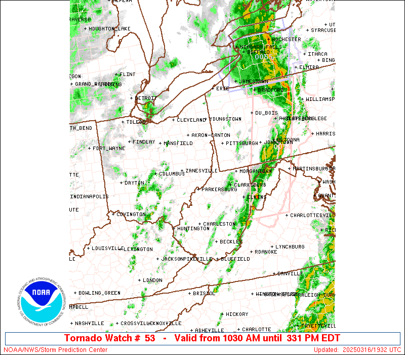
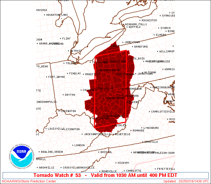
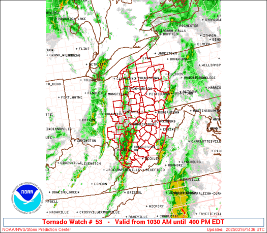
Tornado Watch Number 53
NWS Storm Prediction Center Norman OK
1030 AM EDT Sun Mar 16 2025
The NWS Storm Prediction Center has issued a
* Tornado Watch for portions of
Eastern Ohio
Western Pennsylvania
West Virginia
* Effective this Sunday morning and afternoon from 1030 AM until
400 PM EDT.
* Primary threats include...
A few tornadoes possible
Scattered damaging wind gusts to 70 mph likely
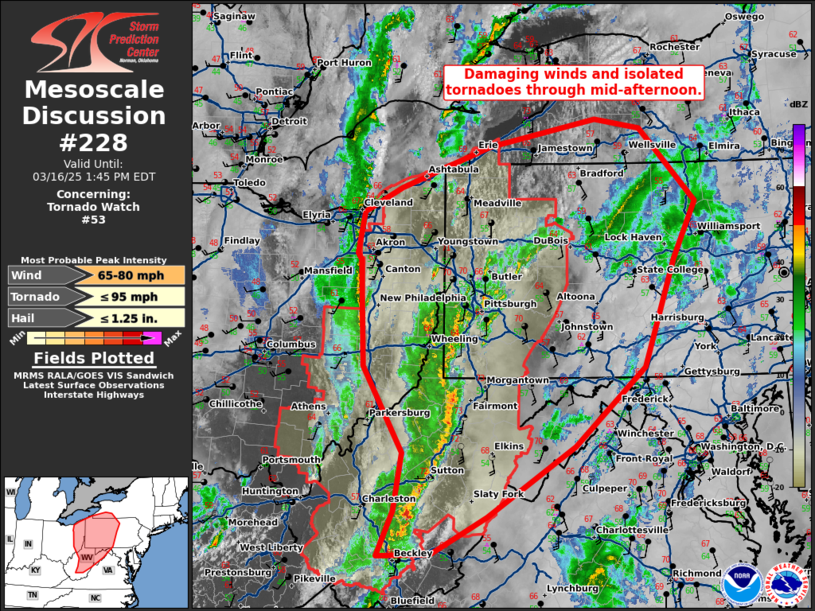
SUMMARY...Multiple lines and clusters of thunderstorms will continue
to develop and intensify as they move quickly northeastward late
this morning and into the afternoon. Scattered damaging winds will
likely be the main threat with this activity, with peak gusts
perhaps reaching up to 60-70 mph. But, the environment will also
support some threat for a few line-embedded tornadoes as well.
The tornado watch area is approximately along and 60 statute miles
east and west of a line from 30 miles northwest of Franklin PA to 40
miles south southeast of Charleston WV. For a complete depiction of
the watch see the associated watch outline update (WOUS64 KWNS
WOU3).
PRECAUTIONARY/PREPAREDNESS ACTIONS...
REMEMBER...A Tornado Watch means conditions are favorable for
tornadoes and severe thunderstorms in and close to the watch
area. Persons in these areas should be on the lookout for
threatening weather conditions and listen for later statements
and possible warnings.
&&
OTHER WATCH INFORMATION...CONTINUE...WW 51...WW 52...
AVIATION...Tornadoes and a few severe thunderstorms with hail
surface and aloft to 1 inch. Extreme turbulence and surface wind
gusts to 60 knots. A few cumulonimbi with maximum tops to 350. Mean
storm motion vector 22045.
...Gleason
   SEL3

   URGENT - IMMEDIATE BROADCAST REQUESTED
   Tornado Watch Number 53
   NWS Storm Prediction Center Norman OK
   1030 AM EDT Sun Mar 16 2025

   The NWS Storm Prediction Center has issued a

   * Tornado Watch for portions of
     Eastern Ohio
     Western Pennsylvania
     West Virginia

   * Effective this Sunday morning and afternoon from 1030 AM until
     400 PM EDT.

   * Primary threats include...
     A few tornadoes possible
     Scattered damaging wind gusts to 70 mph likely

   SUMMARY...Multiple lines and clusters of thunderstorms will continue
   to develop and intensify as they move quickly northeastward late
   this morning and into the afternoon. Scattered damaging winds will
   likely be the main threat with this activity, with peak gusts
   perhaps reaching up to 60-70 mph. But, the environment will also
   support some threat for a few line-embedded tornadoes as well.

   The tornado watch area is approximately along and 60 statute miles
   east and west of a line from 30 miles northwest of Franklin PA to 40
   miles south southeast of Charleston WV. For a complete depiction of
   the watch see the associated watch outline update (WOUS64 KWNS
   WOU3).

   PRECAUTIONARY/PREPAREDNESS ACTIONS...

   REMEMBER...A Tornado Watch means conditions are favorable for
   tornadoes and severe thunderstorms in and close to the watch
   area. Persons in these areas should be on the lookout for
   threatening weather conditions and listen for later statements
   and possible warnings.

   &&

   OTHER WATCH INFORMATION...CONTINUE...WW 51...WW 52...

   AVIATION...Tornadoes and a few severe thunderstorms with hail
   surface and aloft to 1 inch. Extreme turbulence and surface wind
   gusts to 60 knots. A few cumulonimbi with maximum tops to 350. Mean
   storm motion vector 22045.

   ...Gleason
 Note:
The Aviation Watch (SAW) product is an approximation to the watch area.
The actual watch is depicted by the shaded areas.
Note:
The Aviation Watch (SAW) product is an approximation to the watch area.
The actual watch is depicted by the shaded areas.
   SAW3
   WW 53 TORNADO OH PA WV 161430Z - 162000Z
   AXIS..60 STATUTE MILES EAST AND WEST OF LINE..
   30NW FKL/FRANKLIN PA/ - 40SSE CRW/CHARLESTON WV/
   ..AVIATION COORDS.. 50NM E/W /20S ERI - 9WNW BKW/
   HAIL SURFACE AND ALOFT..1 INCH. WIND GUSTS..60 KNOTS.
   MAX TOPS TO 350. MEAN STORM MOTION VECTOR 22045.

   LAT...LON 41687912 37828021 37828241 41688144

   THIS IS AN APPROXIMATION TO THE WATCH AREA.  FOR A
   COMPLETE DEPICTION OF THE WATCH SEE WOUS64 KWNS
   FOR WOU3.
Watch 53 Status Report Messages:
STATUS REPORT #3 ON WW 53

VALID 161825Z - 161940Z

SEVERE WEATHER THREAT CONTINUES RIGHT OF A LINE FROM 20 N SSU TO
10 ESE MGW TO 15 NNW ERI.

..LYONS..03/16/25

ATTN...WFO...CLE...RLX...PBZ...

&&

STATUS REPORT FOR WT 53

SEVERE WEATHER THREAT CONTINUES FOR THE FOLLOWING AREAS

PAC005-031-039-049-053-063-065-121-161940-

PA
.    PENNSYLVANIA COUNTIES INCLUDED ARE

ARMSTRONG	     CLARION		 CRAWFORD
ERIE		     FOREST		 INDIANA
JEFFERSON	     VENANGO
$$


WVC075-077-083-093-161940-

WV
.    WEST VIRGINIA COUNTIES INCLUDED ARE

POCAHONTAS	     PRESTON		 RANDOLPH
TUCKER
$$


THE WATCH STATUS MESSAGE IS FOR GUIDANCE PURPOSES ONLY.  PLEASE
REFER TO WATCH COUNTY NOTIFICATION STATEMENTS FOR OFFICIAL
INFORMATION ON COUNTIES...INDEPENDENT CITIES AND MARINE ZONES
CLEARED FROM SEVERE THUNDERSTORM AND TORNADO WATCHES.
$$

STATUS REPORT #2 ON WW 53

VALID 161655Z - 161740Z

SEVERE WEATHER THREAT CONTINUES RIGHT OF A LINE FROM 30 W BKW TO
45 ENE CRW TO 35 E PKB TO 20 SE ZZV TO 30 NNE CLE.

..LYONS..03/16/25

ATTN...WFO...CLE...RLX...PBZ...

&&

STATUS REPORT FOR WT 53

SEVERE WEATHER THREAT CONTINUES FOR THE FOLLOWING AREAS

OHC007-013-019-029-055-059-067-081-085-099-111-121-133-151-153-
155-157-161740-

OH
.    OHIO COUNTIES INCLUDED ARE

ASHTABULA	     BELMONT		 CARROLL
COLUMBIANA	     GEAUGA		 GUERNSEY
HARRISON	     JEFFERSON		 LAKE
MAHONING	     MONROE		 NOBLE
PORTAGE 	     STARK		 SUMMIT
TRUMBULL	     TUSCARAWAS
$$


PAC003-005-007-019-031-039-049-051-053-059-063-065-073-085-121-
125-129-161740-

PA
.    PENNSYLVANIA COUNTIES INCLUDED ARE

ALLEGHENY	     ARMSTRONG		 BEAVER
BUTLER		     CLARION		 CRAWFORD
ERIE		     FAYETTE		 FOREST
GREENE		     INDIANA		 JEFFERSON
LAWRENCE	     MERCER		 VENANGO
WASHINGTON	     WESTMORELAND
$$


WVC001-007-009-015-017-019-021-029-033-041-049-051-061-067-069-
075-077-081-083-091-093-095-097-101-103-161740-

WV
.    WEST VIRGINIA COUNTIES INCLUDED ARE

BARBOUR 	     BRAXTON		 BROOKE
CLAY		     DODDRIDGE		 FAYETTE
GILMER		     HANCOCK		 HARRISON
LEWIS		     MARION		 MARSHALL
MONONGALIA	     NICHOLAS		 OHIO
POCAHONTAS	     PRESTON		 RALEIGH
RANDOLPH	     TAYLOR		 TUCKER
TYLER		     UPSHUR		 WEBSTER
WETZEL
$$


THE WATCH STATUS MESSAGE IS FOR GUIDANCE PURPOSES ONLY.  PLEASE
REFER TO WATCH COUNTY NOTIFICATION STATEMENTS FOR OFFICIAL
INFORMATION ON COUNTIES...INDEPENDENT CITIES AND MARINE ZONES
CLEARED FROM SEVERE THUNDERSTORM AND TORNADO WATCHES.
$$

STATUS REPORT #1 ON WW 53

VALID 161550Z - 161640Z

THE SEVERE WEATHER THREAT CONTINUES ACROSS THE ENTIRE WATCH AREA.

..LYONS..03/16/25

ATTN...WFO...CLE...RLX...PBZ...

&&

STATUS REPORT FOR WT 53

SEVERE WEATHER THREAT CONTINUES FOR THE FOLLOWING AREAS

OHC007-009-013-019-029-031-053-055-059-067-079-081-085-099-105-
111-115-119-121-127-133-151-153-155-157-163-167-161640-

OH
.    OHIO COUNTIES INCLUDED ARE

ASHTABULA	     ATHENS		 BELMONT
CARROLL 	     COLUMBIANA 	 COSHOCTON
GALLIA		     GEAUGA		 GUERNSEY
HARRISON	     JACKSON		 JEFFERSON
LAKE		     MAHONING		 MEIGS
MONROE		     MORGAN		 MUSKINGUM
NOBLE		     PERRY		 PORTAGE
STARK		     SUMMIT		 TRUMBULL
TUSCARAWAS	     VINTON		 WASHINGTON
$$


PAC003-005-007-019-031-039-049-051-053-059-063-065-073-085-121-
125-129-161640-

PA
.    PENNSYLVANIA COUNTIES INCLUDED ARE

ALLEGHENY	     ARMSTRONG		 BEAVER
BUTLER		     CLARION		 CRAWFORD
ERIE		     FAYETTE		 FOREST
GREENE		     INDIANA		 JEFFERSON
LAWRENCE	     MERCER		 VENANGO
WASHINGTON	     WESTMORELAND
$$


WVC001-005-007-009-013-015-017-019-021-029-033-035-039-041-043-
045-049-051-053-059-061-067-069-073-075-077-079-081-083-085-087-
091-093-095-097-101-103-105-107-109-161640-

WV
.    WEST VIRGINIA COUNTIES INCLUDED ARE

BARBOUR 	     BOONE		 BRAXTON
BROOKE		     CALHOUN		 CLAY
DODDRIDGE	     FAYETTE		 GILMER
HANCOCK 	     HARRISON		 JACKSON
KANAWHA 	     LEWIS		 LINCOLN
LOGAN		     MARION		 MARSHALL
MASON		     MINGO		 MONONGALIA
NICHOLAS	     OHIO		 PLEASANTS
POCAHONTAS	     PRESTON		 PUTNAM
RALEIGH 	     RANDOLPH		 RITCHIE
ROANE		     TAYLOR		 TUCKER
TYLER		     UPSHUR		 WEBSTER
WETZEL		     WIRT		 WOOD
WYOMING
$$


THE WATCH STATUS MESSAGE IS FOR GUIDANCE PURPOSES ONLY.  PLEASE
REFER TO WATCH COUNTY NOTIFICATION STATEMENTS FOR OFFICIAL
INFORMATION ON COUNTIES...INDEPENDENT CITIES AND MARINE ZONES
CLEARED FROM SEVERE THUNDERSTORM AND TORNADO WATCHES.
$$
Note:
Click for Complete Product Text.
Tornadoes
Probability of 2 or more tornadoes
|
Mod (50%)
|
Probability of 1 or more strong (EF2-EF5) tornadoes
|
Low (10%)
|
Wind
Probability of 10 or more severe wind events
|
High (70%)
|
Probability of 1 or more wind events > 65 knots
|
Low (20%)
|
Hail
Probability of 10 or more severe hail events
|
Low (10%)
|
Probability of 1 or more hailstones > 2 inches
|
Low (<5%)
|
Combined Severe Hail/Wind
Probability of 6 or more combined severe hail/wind events
|
High (90%)
|
For each watch, probabilities for particular events inside the watch
(listed above in each table) are determined by the issuing forecaster.
The "Low" category contains probability values ranging from less than 2%
to 20% (EF2-EF5 tornadoes), less than 5% to 20% (all other probabilities),
"Moderate" from 30% to 60%, and "High" from 70% to greater than 95%.
High values are bolded and lighter in color to provide awareness of
an increased threat for a particular event.


 @NWSSPC