Note:
The expiration time in the watch graphic is amended if the watch is
replaced, cancelled or extended.
Note:
Note:
The expiration time in the watch graphic is amended if the watch is
replaced, cancelled or extended.
Note: Click for
Watch Status Reports.
SEL2
URGENT - IMMEDIATE BROADCAST REQUESTED
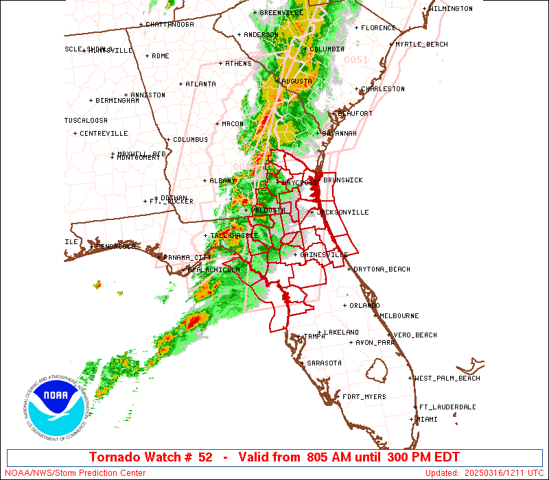
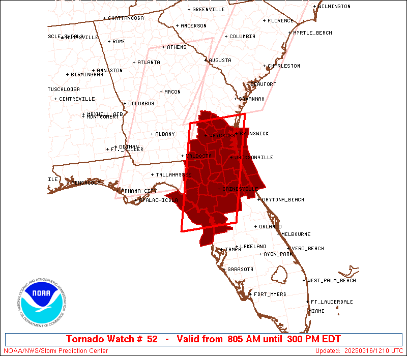
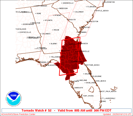
Tornado Watch Number 52
NWS Storm Prediction Center Norman OK
805 AM EDT Sun Mar 16 2025
The NWS Storm Prediction Center has issued a
* Tornado Watch for portions of
North-Central and North Florida
Southeast Georgia
Coastal Waters
* Effective this Sunday morning and afternoon from 805 AM until
300 PM EDT.
* Primary threats include...
A couple tornadoes possible
Scattered damaging wind gusts to 70 mph possible
Isolated large hail events to 1.5 inches in diameter possible
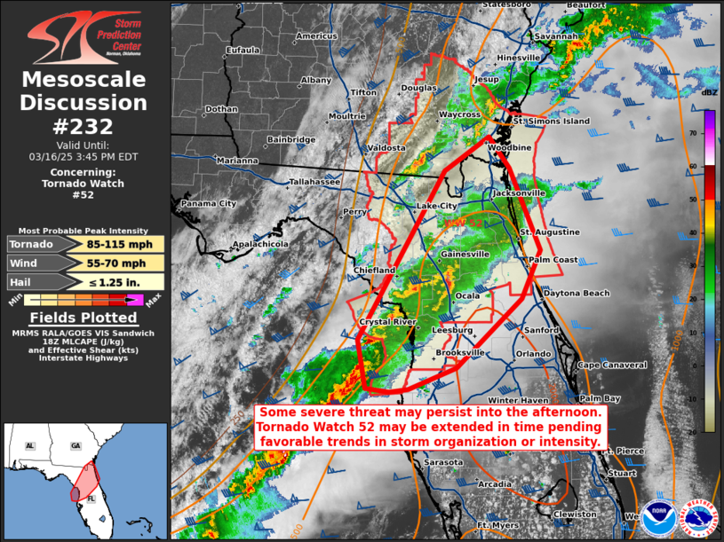
SUMMARY...A broken band of primarily cellular storms will continue
east into the Watch area this morning and afternoon. Relatively
moist low levels and strongly sheared wind profiles will support
organized storms, including supercells and small linear segments. A
couple of tornadoes are possible, as well as damaging gusts with the
stronger storms.
The tornado watch area is approximately along and 55 statute miles
east and west of a line from 40 miles northeast of Waycross GA to 50
miles southwest of Ocala FL. For a complete depiction of the watch
see the associated watch outline update (WOUS64 KWNS WOU2).
PRECAUTIONARY/PREPAREDNESS ACTIONS...
REMEMBER...A Tornado Watch means conditions are favorable for
tornadoes and severe thunderstorms in and close to the watch
area. Persons in these areas should be on the lookout for
threatening weather conditions and listen for later statements
and possible warnings.
&&
OTHER WATCH INFORMATION...CONTINUE...WW 50...WW 51...
AVIATION...Tornadoes and a few severe thunderstorms with hail
surface and aloft to 1.5 inches. Extreme turbulence and surface wind
gusts to 60 knots. A few cumulonimbi with maximum tops to 500. Mean
storm motion vector 25035.
...Smith

   SEL2

   URGENT - IMMEDIATE BROADCAST REQUESTED
   Tornado Watch Number 52
   NWS Storm Prediction Center Norman OK
   805 AM EDT Sun Mar 16 2025

   The NWS Storm Prediction Center has issued a

   * Tornado Watch for portions of
     North-Central and North Florida
     Southeast Georgia
     Coastal Waters

   * Effective this Sunday morning and afternoon from 805 AM until
     300 PM EDT.

   * Primary threats include...
     A couple tornadoes possible
     Scattered damaging wind gusts to 70 mph possible
     Isolated large hail events to 1.5 inches in diameter possible

   SUMMARY...A broken band of primarily cellular storms will continue
   east into the Watch area this morning and afternoon.  Relatively
   moist low levels and strongly sheared wind profiles will support
   organized storms, including supercells and small linear segments.  A
   couple of tornadoes are possible, as well as damaging gusts with the
   stronger storms.

   The tornado watch area is approximately along and 55 statute miles
   east and west of a line from 40 miles northeast of Waycross GA to 50
   miles southwest of Ocala FL. For a complete depiction of the watch
   see the associated watch outline update (WOUS64 KWNS WOU2).

   PRECAUTIONARY/PREPAREDNESS ACTIONS...

   REMEMBER...A Tornado Watch means conditions are favorable for
   tornadoes and severe thunderstorms in and close to the watch
   area. Persons in these areas should be on the lookout for
   threatening weather conditions and listen for later statements
   and possible warnings.

   &&

   OTHER WATCH INFORMATION...CONTINUE...WW 50...WW 51...

   AVIATION...Tornadoes and a few severe thunderstorms with hail
   surface and aloft to 1.5 inches. Extreme turbulence and surface wind
   gusts to 60 knots. A few cumulonimbi with maximum tops to 500. Mean
   storm motion vector 25035.

   ...Smith
 Note:
The Aviation Watch (SAW) product is an approximation to the watch area.
The actual watch is depicted by the shaded areas.
Note:
The Aviation Watch (SAW) product is an approximation to the watch area.
The actual watch is depicted by the shaded areas.
   SAW2
   WW 52 TORNADO FL GA CW 161205Z - 161900Z
   AXIS..55 STATUTE MILES EAST AND WEST OF LINE..
   40NE AYS/WAYCROSS GA/ - 50SW OCF/OCALA FL/
   ..AVIATION COORDS.. 50NM E/W /31ENE AMG - 45N PIE/
   HAIL SURFACE AND ALOFT..1.5 INCHES. WIND GUSTS..60 KNOTS.
   MAX TOPS TO 500. MEAN STORM MOTION VECTOR 25035.

   LAT...LON 31668098 28658190 28658371 31668285

   THIS IS AN APPROXIMATION TO THE WATCH AREA.  FOR A
   COMPLETE DEPICTION OF THE WATCH SEE WOUS64 KWNS
   FOR WOU2.
Watch 52 Status Report Messages:
STATUS REPORT #4 ON WW 52

VALID 161825Z - 161940Z

SEVERE WEATHER THREAT CONTINUES RIGHT OF A LINE FROM 30 SW CTY TO
25 SSW AYS TO 30 SSE SAV.

..LYONS..03/16/25

ATTN...WFO...JAX...TBW...TAE...

&&

STATUS REPORT FOR WT 52

SEVERE WEATHER THREAT CONTINUES FOR THE FOLLOWING AREAS

FLC001-003-007-017-019-031-035-041-053-075-083-089-107-109-125-
161940-

FL
.    FLORIDA COUNTIES INCLUDED ARE

ALACHUA 	     BAKER		 BRADFORD
CITRUS		     CLAY		 DUVAL
FLAGLER 	     GILCHRIST		 HERNANDO
LEVY		     MARION		 NASSAU
PUTNAM		     ST. JOHNS		 UNION
$$


GAC025-039-049-101-127-161940-

GA
.    GEORGIA COUNTIES INCLUDED ARE

BRANTLEY	     CAMDEN		 CHARLTON
ECHOLS		     GLYNN
$$


AMZ450-452-454-GMZ850-161940-

CW

.    ADJACENT COASTAL WATERS INCLUDED ARE

COASTAL WATERS FROM ALTAMAHA SOUND TO FERNANDINA BEACH FL OUT 20
NM

COASTAL WATERS FROM FERNANDINA BEACH TO ST. AUGUSTINE FL OUT 20
NM

COASTAL WATERS FROM ST. AUGUSTINE TO FLAGLER BEACH FL OUT 20 NM

COASTAL WATERS FROM TARPON SPRINGS TO SUWANNEE RIVER FL OUT 20 NM

$$
THE WATCH STATUS MESSAGE IS FOR GUIDANCE PURPOSES ONLY.  PLEASE
REFER TO WATCH COUNTY NOTIFICATION STATEMENTS FOR OFFICIAL
INFORMATION ON COUNTIES...INDEPENDENT CITIES AND MARINE ZONES
CLEARED FROM SEVERE THUNDERSTORM AND TORNADO WATCHES.
$$

STATUS REPORT #3 ON WW 52

VALID 161655Z - 161740Z

SEVERE WEATHER THREAT CONTINUES RIGHT OF A LINE FROM 30 SW CTY TO
30 NNW GNV TO 25 ENE VLD TO 20 ENE AYS TO 40 WSW SAV.

..LYONS..03/16/25

ATTN...WFO...JAX...TBW...TAE...

&&

STATUS REPORT FOR WT 52

SEVERE WEATHER THREAT CONTINUES FOR THE FOLLOWING AREAS

FLC001-003-007-017-019-031-035-041-053-075-083-089-107-109-125-
161740-

FL
.    FLORIDA COUNTIES INCLUDED ARE

ALACHUA 	     BAKER		 BRADFORD
CITRUS		     CLAY		 DUVAL
FLAGLER 	     GILCHRIST		 HERNANDO
LEVY		     MARION		 NASSAU
PUTNAM		     ST. JOHNS		 UNION
$$


GAC025-039-049-065-101-127-229-299-305-161740-

GA
.    GEORGIA COUNTIES INCLUDED ARE

BRANTLEY	     CAMDEN		 CHARLTON
CLINCH		     ECHOLS		 GLYNN
PIERCE		     WARE		 WAYNE
$$


AMZ450-452-454-GMZ765-850-161740-

CW

.    ADJACENT COASTAL WATERS INCLUDED ARE

COASTAL WATERS FROM ALTAMAHA SOUND TO FERNANDINA BEACH FL OUT 20
NM

COASTAL WATERS FROM FERNANDINA BEACH TO ST. AUGUSTINE FL OUT 20
NM

COASTAL WATERS FROM ST. AUGUSTINE TO FLAGLER BEACH FL OUT 20 NM

COASTAL WATERS FROM  SUWANNEE RIVER TO KEATON BEACH OUT 20 NM

COASTAL WATERS FROM TARPON SPRINGS TO SUWANNEE RIVER FL OUT 20 NM

$$
THE WATCH STATUS MESSAGE IS FOR GUIDANCE PURPOSES ONLY.  PLEASE
REFER TO WATCH COUNTY NOTIFICATION STATEMENTS FOR OFFICIAL
INFORMATION ON COUNTIES...INDEPENDENT CITIES AND MARINE ZONES
CLEARED FROM SEVERE THUNDERSTORM AND TORNADO WATCHES.
$$

STATUS REPORT #2 ON WW 52

VALID 161550Z - 161640Z

SEVERE WEATHER THREAT CONTINUES RIGHT OF A LINE FROM 15 ENE VLD
TO 15 SW AYS TO 30 SE VDI.

..LYONS..03/16/25

ATTN...WFO...JAX...TBW...TAE...

&&

STATUS REPORT FOR WT 52

SEVERE WEATHER THREAT CONTINUES FOR THE FOLLOWING AREAS

FLC001-003-007-017-019-023-029-031-035-041-047-053-067-075-083-
089-107-109-121-125-161640-

FL
.    FLORIDA COUNTIES INCLUDED ARE

ALACHUA 	     BAKER		 BRADFORD
CITRUS		     CLAY		 COLUMBIA
DIXIE		     DUVAL		 FLAGLER
GILCHRIST	     HAMILTON		 HERNANDO
LAFAYETTE	     LEVY		 MARION
NASSAU		     PUTNAM		 ST. JOHNS
SUWANNEE	     UNION
$$


GAC025-039-049-065-101-127-229-299-305-161640-

GA
.    GEORGIA COUNTIES INCLUDED ARE

BRANTLEY	     CAMDEN		 CHARLTON
CLINCH		     ECHOLS		 GLYNN
PIERCE		     WARE		 WAYNE
$$


AMZ450-452-454-GMZ765-850-161640-

CW

.    ADJACENT COASTAL WATERS INCLUDED ARE

COASTAL WATERS FROM ALTAMAHA SOUND TO FERNANDINA BEACH FL OUT 20
NM

COASTAL WATERS FROM FERNANDINA BEACH TO ST. AUGUSTINE FL OUT 20
NM

COASTAL WATERS FROM ST. AUGUSTINE TO FLAGLER BEACH FL OUT 20 NM

COASTAL WATERS FROM  SUWANNEE RIVER TO KEATON BEACH OUT 20 NM

COASTAL WATERS FROM TARPON SPRINGS TO SUWANNEE RIVER FL OUT 20 NM

$$
THE WATCH STATUS MESSAGE IS FOR GUIDANCE PURPOSES ONLY.  PLEASE
REFER TO WATCH COUNTY NOTIFICATION STATEMENTS FOR OFFICIAL
INFORMATION ON COUNTIES...INDEPENDENT CITIES AND MARINE ZONES
CLEARED FROM SEVERE THUNDERSTORM AND TORNADO WATCHES.
$$

STATUS REPORT #1 ON WW 52

VALID 161405Z - 161540Z

THE SEVERE WEATHER THREAT CONTINUES ACROSS THE ENTIRE WATCH AREA.

..LYONS..03/16/25

ATTN...WFO...JAX...TBW...TAE...

&&

STATUS REPORT FOR WT 52

SEVERE WEATHER THREAT CONTINUES FOR THE FOLLOWING AREAS

FLC001-003-007-017-019-023-029-031-035-041-047-053-067-075-083-
089-107-109-121-125-161540-

FL
.    FLORIDA COUNTIES INCLUDED ARE

ALACHUA 	     BAKER		 BRADFORD
CITRUS		     CLAY		 COLUMBIA
DIXIE		     DUVAL		 FLAGLER
GILCHRIST	     HAMILTON		 HERNANDO
LAFAYETTE	     LEVY		 MARION
NASSAU		     PUTNAM		 ST. JOHNS
SUWANNEE	     UNION
$$


GAC001-005-025-039-049-065-101-127-229-299-305-161540-

GA
.    GEORGIA COUNTIES INCLUDED ARE

APPLING 	     BACON		 BRANTLEY
CAMDEN		     CHARLTON		 CLINCH
ECHOLS		     GLYNN		 PIERCE
WARE		     WAYNE
$$


AMZ450-452-454-GMZ765-850-161540-

CW

.    ADJACENT COASTAL WATERS INCLUDED ARE

COASTAL WATERS FROM ALTAMAHA SOUND TO FERNANDINA BEACH FL OUT 20
NM

COASTAL WATERS FROM FERNANDINA BEACH TO ST. AUGUSTINE FL OUT 20
NM

COASTAL WATERS FROM ST. AUGUSTINE TO FLAGLER BEACH FL OUT 20 NM

COASTAL WATERS FROM  SUWANNEE RIVER TO KEATON BEACH OUT 20 NM

COASTAL WATERS FROM TARPON SPRINGS TO SUWANNEE RIVER FL OUT 20 NM

$$
THE WATCH STATUS MESSAGE IS FOR GUIDANCE PURPOSES ONLY.  PLEASE
REFER TO WATCH COUNTY NOTIFICATION STATEMENTS FOR OFFICIAL
INFORMATION ON COUNTIES...INDEPENDENT CITIES AND MARINE ZONES
CLEARED FROM SEVERE THUNDERSTORM AND TORNADO WATCHES.
$$
Note:
Click for Complete Product Text.
Tornadoes
Probability of 2 or more tornadoes
|
Mod (40%)
|
Probability of 1 or more strong (EF2-EF5) tornadoes
|
Low (20%)
|
Wind
Probability of 10 or more severe wind events
|
Mod (40%)
|
Probability of 1 or more wind events > 65 knots
|
Low (20%)
|
Hail
Probability of 10 or more severe hail events
|
Low (20%)
|
Probability of 1 or more hailstones > 2 inches
|
Low (10%)
|
Combined Severe Hail/Wind
Probability of 6 or more combined severe hail/wind events
|
Mod (60%)
|
For each watch, probabilities for particular events inside the watch
(listed above in each table) are determined by the issuing forecaster.
The "Low" category contains probability values ranging from less than 2%
to 20% (EF2-EF5 tornadoes), less than 5% to 20% (all other probabilities),
"Moderate" from 30% to 60%, and "High" from 70% to greater than 95%.
High values are bolded and lighter in color to provide awareness of
an increased threat for a particular event.


 @NWSSPC