|
| Mesoscale Discussion 149 |
|
[an error occurred while processing this directive]
|
|
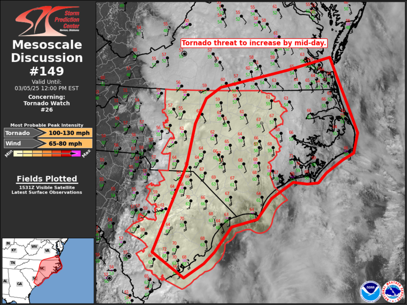
   Mesoscale Discussion 0149
   NWS Storm Prediction Center Norman OK
   0935 AM CST Wed Mar 05 2025

   Areas affected...Central North Carolina and eastern South Carolina.

   Concerning...Tornado Watch 26...

   Valid 051535Z - 051700Z

   The severe weather threat for Tornado Watch 26 continues.

   SUMMARY...Wind damage/tornado threat to increase by mid-day.

   DISCUSSION...A convective line has produced consistent wind damage
   this morning with a 52 knot gust at 1512Z at KBUY. This wind threat
   will continue and likely increase as the environment downstream
   destabilizes. In addition, low-level moisture advection and some
   heating through broken cloud cover should lead to 500 to 1000 J/kg
   MLCAPE by early afternoon across parts of eastern South Carolina and
   eastern North Carolina. Given 450+ m2/s2 0-1km SRH and 75 knots at
   1.5 km from the KRAX VWP, the embedded QLCS tornado threat and
   severe wind threat will likely increase as the line interacts with
   greater instability. In addition, a few embedded supercells may be
   possible where instability is greatest which could lead to regions
   of locally higher threat within the line.

   Expect an increase in organization and intensity of the squall line
   (first indicated by the presence of lightning) within the next 1 to
   2 hours with the threat persisting through the afternoon/evening. An
   additional tornado watch will eventually be needed downstream of
   watch 26 across parts of eastern North Carolina and southeast
   Virginia.

   ..Bentley/Mosier.. 03/05/2025

   ...Please see www.spc.noaa.gov for graphic product...

   ATTN...WFO...AKQ...MHX...RAH...ILM...RNK...CHS...CAE...

   LAT...LON   33078068 34927984 35837964 36377935 36617897 36977719
               37247608 36677584 36227563 35927551 35607539 35177551
               35047579 34777622 34567644 34547672 34587708 34237764
               33787802 33637867 33087909 32837937 32537987 33078068
|
|
Top/All Mesoscale Discussions/Forecast Products/Home
|
|


 @NWSSPC