|
| Mesoscale Discussion 144 |
|
[an error occurred while processing this directive]
|
|
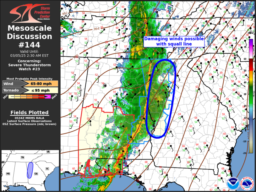
   Mesoscale Discussion 0144
   NWS Storm Prediction Center Norman OK
   1136 PM CST Tue Mar 04 2025

   Areas affected...Far eastern Alabama and northwestern Georgia

   Concerning...Severe Thunderstorm Watch 23...

   Valid 050536Z - 050730Z

   The severe weather threat for Severe Thunderstorm Watch 23
   continues.

   SUMMARY...Damaging winds are expected along the surging squall line.

   DISCUSSION...Strongly forced squall line continues its eastward
   progression at roughly 30kt. While buoyancy remains weak, very
   strong ESRH is noted ahead of the convection. Latest 1km VAD winds
   at FFC are 70kt and this may continue to favor stronger flow mixing
   down as the linear MCS advances east over the next few hours. With
   time, forecast soundings do suggest convection will gradually
   weaken, perhaps limiting the downward transfer of flow. Until then,
   damaging winds are likely along the line.

   ..Darrow.. 03/05/2025

   ...Please see www.spc.noaa.gov for graphic product...

   ATTN...WFO...FFC...BMX...

   LAT...LON   32268529 34688492 34598395 32078440 32268529
|
|
Top/All Mesoscale Discussions/Forecast Products/Home
|
|


 @NWSSPC