Note:
The expiration time in the watch graphic is amended if the watch is
replaced, cancelled or extended.
Note:
Note:
The expiration time in the watch graphic is amended if the watch is
replaced, cancelled or extended.
Note: Click for
Watch Status Reports.
SEL5
URGENT - IMMEDIATE BROADCAST REQUESTED
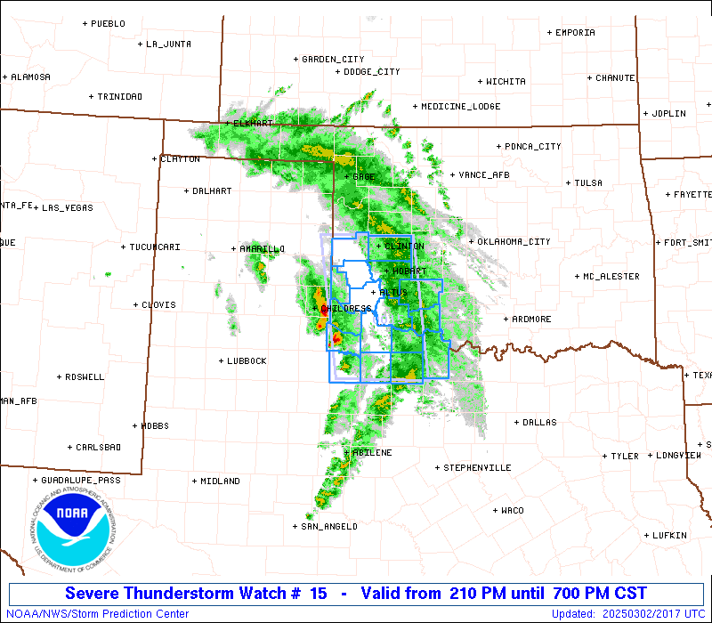
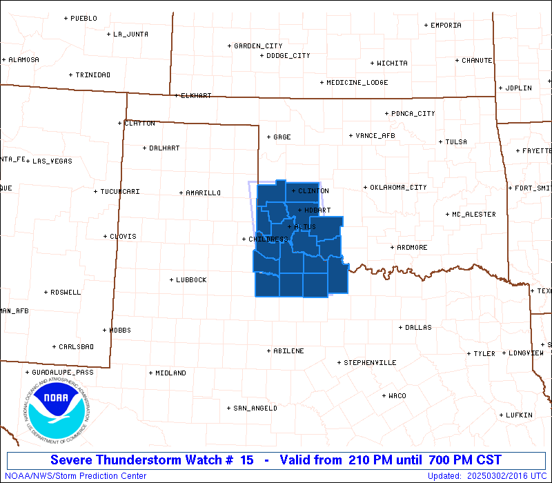
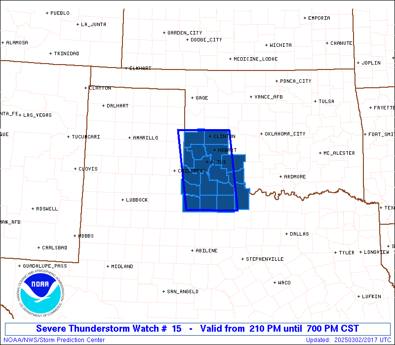
Severe Thunderstorm Watch Number 15
NWS Storm Prediction Center Norman OK
210 PM CST Sun Mar 2 2025
The NWS Storm Prediction Center has issued a
* Severe Thunderstorm Watch for portions of
Southwest Oklahoma
Western North Texas
* Effective this Sunday afternoon and evening from 210 PM until
700 PM CST.
* Primary threats include...
Scattered large hail events to 1.5 inches in diameter possible
Isolated damaging wind gusts to 70 mph possible
A tornado or two possible
SUMMARY...Thunderstorms will move quickly east-northeastward this
afternoon and early evening while posing a threat for large hail up
to 1-1.5 inches in diameter and 60-70 mph winds. Although low-level
moisture remains limited, a tornado or two may also occur with any
sustained supercell.
The severe thunderstorm watch area is approximately along and 45
statute miles east and west of a line from 15 miles northwest of
Clinton OK to 50 miles southwest of Wichita Falls TX. For a complete
depiction of the watch see the associated watch outline update
(WOUS64 KWNS WOU5).
PRECAUTIONARY/PREPAREDNESS ACTIONS...
REMEMBER...A Severe Thunderstorm Watch means conditions are
favorable for severe thunderstorms in and close to the watch area.
Persons in these areas should be on the lookout for threatening
weather conditions and listen for later statements and possible
warnings. Severe thunderstorms can and occasionally do produce
tornadoes.
&&
AVIATION...A few severe thunderstorms with hail surface and aloft to
1.5 inches. Extreme turbulence and surface wind gusts to 60 knots. A
few cumulonimbi with maximum tops to 400. Mean storm motion vector
22035.
...Gleason

   SEL5

   URGENT - IMMEDIATE BROADCAST REQUESTED
   Severe Thunderstorm Watch Number 15
   NWS Storm Prediction Center Norman OK
   210 PM CST Sun Mar 2 2025

   The NWS Storm Prediction Center has issued a

   * Severe Thunderstorm Watch for portions of
     Southwest Oklahoma
     Western North Texas

   * Effective this Sunday afternoon and evening from 210 PM until
     700 PM CST.

   * Primary threats include...
     Scattered large hail events to 1.5 inches in diameter possible
     Isolated damaging wind gusts to 70 mph possible
     A tornado or two possible

   SUMMARY...Thunderstorms will move quickly east-northeastward this
   afternoon and early evening while posing a threat for large hail up
   to 1-1.5 inches in diameter and 60-70 mph winds. Although low-level
   moisture remains limited, a tornado or two may also occur with any
   sustained supercell.

   The severe thunderstorm watch area is approximately along and 45
   statute miles east and west of a line from 15 miles northwest of
   Clinton OK to 50 miles southwest of Wichita Falls TX. For a complete
   depiction of the watch see the associated watch outline update
   (WOUS64 KWNS WOU5).

   PRECAUTIONARY/PREPAREDNESS ACTIONS...

   REMEMBER...A Severe Thunderstorm Watch means conditions are
   favorable for severe thunderstorms in and close to the watch area.
   Persons in these areas should be on the lookout for threatening
   weather conditions and listen for later statements and possible
   warnings. Severe thunderstorms can and occasionally do produce
   tornadoes.

   &&

   AVIATION...A few severe thunderstorms with hail surface and aloft to
   1.5 inches. Extreme turbulence and surface wind gusts to 60 knots. A
   few cumulonimbi with maximum tops to 400. Mean storm motion vector
   22035.

   ...Gleason
 Note:
The Aviation Watch (SAW) product is an approximation to the watch area.
The actual watch is depicted by the shaded areas.
Note:
The Aviation Watch (SAW) product is an approximation to the watch area.
The actual watch is depicted by the shaded areas.
   SAW5
   WW 15 SEVERE TSTM OK TX 022010Z - 030100Z
   AXIS..45 STATUTE MILES EAST AND WEST OF LINE..
   15NW CSM/CLINTON OK/ - 50SW SPS/WICHITA FALLS TX/
   ..AVIATION COORDS.. 40NM E/W /57SSE MMB - 41SW SPS/
   HAIL SURFACE AND ALOFT..1.5 INCHES. WIND GUSTS..60 KNOTS.
   MAX TOPS TO 400. MEAN STORM MOTION VECTOR 22035.

   LAT...LON 35489859 33459833 33459989 35480019

   THIS IS AN APPROXIMATION TO THE WATCH AREA.  FOR A
   COMPLETE DEPICTION OF THE WATCH SEE WOUS64 KWNS
   FOR WOU5.
Watch 15 Status Report Messages:
STATUS REPORT #4 ON WW 15

VALID 022315Z - 030040Z

SEVERE WEATHER THREAT CONTINUES RIGHT OF A LINE FROM 40 NNW MWL
TO 15 ESE LTS TO 20 NW CSM.

..LEITMAN..03/02/25

ATTN...WFO...OUN...

&&

STATUS REPORT FOR WS 15

SEVERE WEATHER THREAT CONTINUES FOR THE FOLLOWING AREAS

OKC031-033-075-141-149-030040-

OK
.    OKLAHOMA COUNTIES INCLUDED ARE

COMANCHE	     COTTON		 KIOWA
TILLMAN 	     WASHITA
$$


TXC077-485-030040-

TX
.    TEXAS COUNTIES INCLUDED ARE

CLAY		     WICHITA
$$


THE WATCH STATUS MESSAGE IS FOR GUIDANCE PURPOSES ONLY.  PLEASE
REFER TO WATCH COUNTY NOTIFICATION STATEMENTS FOR OFFICIAL
INFORMATION ON COUNTIES...INDEPENDENT CITIES AND MARINE ZONES
CLEARED FROM SEVERE THUNDERSTORM AND TORNADO WATCHES.
$$

STATUS REPORT #3 ON WW 15

VALID 022315Z - 030040Z

SEVERE WEATHER THREAT CONTINUES RIGHT OF A LINE FROM 40 NNW MWL
TO 15 ESE LTS TO 20 NW CSM.

..LEITMAN..03/02/25

ATTN...WFO...OUN...

&&

STATUS REPORT FOR WS 15

SEVERE WEATHER THREAT CONTINUES FOR THE FOLLOWING AREAS

OKC031-033-075-141-149-030040-

OK
.    OKLAHOMA COUNTIES INCLUDED ARE

COMANCHE	     COTTON		 KIOWA
TILLMAN 	     WASHITA
$$


TXC077-485-030040-

TX
.    TEXAS COUNTIES INCLUDED ARE

CLAY		     WICHITA
$$


THE WATCH STATUS MESSAGE IS FOR GUIDANCE PURPOSES ONLY.  PLEASE
REFER TO WATCH COUNTY NOTIFICATION STATEMENTS FOR OFFICIAL
INFORMATION ON COUNTIES...INDEPENDENT CITIES AND MARINE ZONES
CLEARED FROM SEVERE THUNDERSTORM AND TORNADO WATCHES.
$$

STATUS REPORT #2 ON WW 15

VALID 022210Z - 022340Z

SEVERE WEATHER THREAT CONTINUES RIGHT OF A LINE FROM 65 NNE ABI
TO 20 WSW LTS TO 35 NW LTS TO 50 W CSM.

..LEITMAN..03/02/25

ATTN...WFO...OUN...

&&

STATUS REPORT FOR WS 15

SEVERE WEATHER THREAT CONTINUES FOR THE FOLLOWING AREAS

OKC009-031-033-055-065-075-141-149-022340-

OK
.    OKLAHOMA COUNTIES INCLUDED ARE

BECKHAM 	     COMANCHE		 COTTON
GREER		     JACKSON		 KIOWA
TILLMAN 	     WASHITA
$$


TXC009-023-077-485-487-022340-

TX
.    TEXAS COUNTIES INCLUDED ARE

ARCHER		     BAYLOR		 CLAY
WICHITA 	     WILBARGER
$$


THE WATCH STATUS MESSAGE IS FOR GUIDANCE PURPOSES ONLY.  PLEASE
REFER TO WATCH COUNTY NOTIFICATION STATEMENTS FOR OFFICIAL
INFORMATION ON COUNTIES...INDEPENDENT CITIES AND MARINE ZONES
CLEARED FROM SEVERE THUNDERSTORM AND TORNADO WATCHES.
$$

STATUS REPORT #1 ON WW 15

VALID 022150Z - 022240Z

THE SEVERE WEATHER THREAT CONTINUES ACROSS THE ENTIRE WATCH AREA.

FOR ADDITIONAL INFORMATION SEE MESOSCALE DISCUSSION 122

..DEAN..03/02/25

ATTN...WFO...OUN...

&&

STATUS REPORT FOR WS 15

SEVERE WEATHER THREAT CONTINUES FOR THE FOLLOWING AREAS

OKC009-031-033-055-057-065-075-141-149-022240-

OK
.    OKLAHOMA COUNTIES INCLUDED ARE

BECKHAM 	     COMANCHE		 COTTON
GREER		     HARMON		 JACKSON
KIOWA		     TILLMAN		 WASHITA
$$


TXC009-023-077-155-197-275-485-487-022240-

TX
.    TEXAS COUNTIES INCLUDED ARE

ARCHER		     BAYLOR		 CLAY
FOARD		     HARDEMAN		 KNOX
WICHITA 	     WILBARGER
$$


THE WATCH STATUS MESSAGE IS FOR GUIDANCE PURPOSES ONLY.  PLEASE
REFER TO WATCH COUNTY NOTIFICATION STATEMENTS FOR OFFICIAL
INFORMATION ON COUNTIES...INDEPENDENT CITIES AND MARINE ZONES
CLEARED FROM SEVERE THUNDERSTORM AND TORNADO WATCHES.
$$
Note:
Click for Complete Product Text.
Tornadoes
Probability of 2 or more tornadoes
|
Low (20%)
|
Probability of 1 or more strong (EF2-EF5) tornadoes
|
Low (10%)
|
Wind
Probability of 10 or more severe wind events
|
Mod (30%)
|
Probability of 1 or more wind events > 65 knots
|
Low (10%)
|
Hail
Probability of 10 or more severe hail events
|
Mod (40%)
|
Probability of 1 or more hailstones > 2 inches
|
Low (20%)
|
Combined Severe Hail/Wind
Probability of 6 or more combined severe hail/wind events
|
High (70%)
|
For each watch, probabilities for particular events inside the watch
(listed above in each table) are determined by the issuing forecaster.
The "Low" category contains probability values ranging from less than 2%
to 20% (EF2-EF5 tornadoes), less than 5% to 20% (all other probabilities),
"Moderate" from 30% to 60%, and "High" from 70% to greater than 95%.
High values are bolded and lighter in color to provide awareness of
an increased threat for a particular event.


 @NWSSPC