Note:
The expiration time in the watch graphic is amended if the watch is
replaced, cancelled or extended.
Note:
Note:
The expiration time in the watch graphic is amended if the watch is
replaced, cancelled or extended.
Note: Click for
Watch Status Reports.
SEL4
URGENT - IMMEDIATE BROADCAST REQUESTED
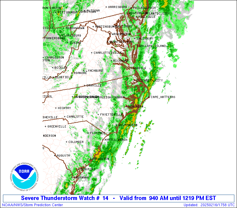
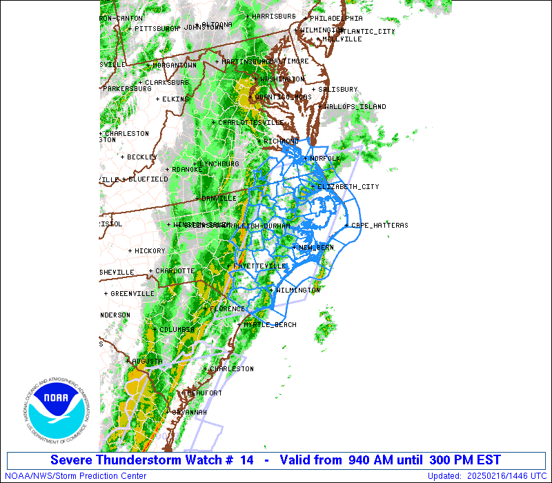
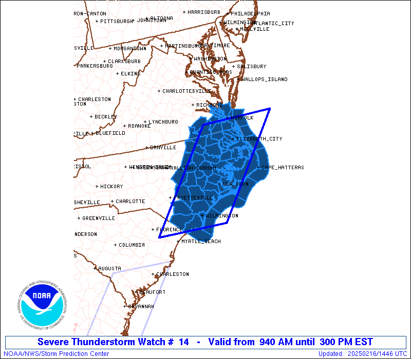
Severe Thunderstorm Watch Number 14
NWS Storm Prediction Center Norman OK
940 AM EST Sun Feb 16 2025
The NWS Storm Prediction Center has issued a
* Severe Thunderstorm Watch for portions of
Eastern North Carolina
Southeast Virginia
Coastal Waters
* Effective this Sunday morning and afternoon from 940 AM until
300 PM EST.
* Primary threats include...
Scattered damaging wind gusts to 70 mph possible
SUMMARY...A fast-moving convective line will move east across the
Watch area. Scattered damaging gusts will be the primary severe
hazard before the severe threat moves east of the coast.
The severe thunderstorm watch area is approximately along and 70
statute miles east and west of a line from 45 miles north northeast
of Elizabeth City NC to 35 miles southwest of Wilmington NC. For a
complete depiction of the watch see the associated watch outline
update (WOUS64 KWNS WOU4).
PRECAUTIONARY/PREPAREDNESS ACTIONS...
REMEMBER...A Severe Thunderstorm Watch means conditions are
favorable for severe thunderstorms in and close to the watch area.
Persons in these areas should be on the lookout for threatening
weather conditions and listen for later statements and possible
warnings. Severe thunderstorms can and occasionally do produce
tornadoes.
&&
OTHER WATCH INFORMATION...CONTINUE...WW 12...WW 13...
AVIATION...A few severe thunderstorms with hail surface and aloft to
0.5 inches. Extreme turbulence and surface wind gusts to 60 knots. A
few cumulonimbi with maximum tops to 300. Mean storm motion vector
26050.
...Smith
 Note:
The Aviation Watch (SAW) product is an approximation to the watch area.
The actual watch is depicted by the shaded areas.
Note:
The Aviation Watch (SAW) product is an approximation to the watch area.
The actual watch is depicted by the shaded areas.
   SAW4
   WW 14 SEVERE TSTM NC VA CW 161440Z - 162000Z
   AXIS..70 STATUTE MILES EAST AND WEST OF LINE..
   45NNE ECG/ELIZABETH CITY NC/ - 35SW ILM/WILMINGTON NC/
   ..AVIATION COORDS.. 60NM E/W /16E ORF - 35SW ILM/
   HAIL SURFACE AND ALOFT..0.5 INCH. WIND GUSTS..60 KNOTS.
   MAX TOPS TO 300. MEAN STORM MOTION VECTOR 26050.

   LAT...LON 36867460 33917711 33917955 36867712

   THIS IS AN APPROXIMATION TO THE WATCH AREA.  FOR A
   COMPLETE DEPICTION OF THE WATCH SEE WOUS64 KWNS
   FOR WOU4.
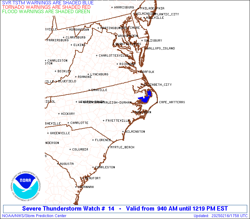
Watch 14 Status Report Messages:
STATUS REPORT #3 ON WW 14

VALID 161710Z - 161840Z

SEVERE WEATHER THREAT CONTINUES RIGHT OF A LINE FROM 60 E ECG TO
20 SSE ORF TO 10 N ORF.

..KERR..02/16/25

ATTN...WFO...MHX...AKQ...ILM...RAH...

&&

STATUS REPORT FOR WS 14

SEVERE WEATHER THREAT CONTINUES FOR THE FOLLOWING AREAS

AMZ136-ANZ632-634-656-161840-

CW

.    ADJACENT COASTAL WATERS INCLUDED ARE

THE WATCH STATUS MESSAGE IS FOR GUIDANCE PURPOSES ONLY.  PLEASE
REFER TO WATCH COUNTY NOTIFICATION STATEMENTS FOR OFFICIAL
INFORMATION ON COUNTIES...INDEPENDENT CITIES AND MARINE ZONES
CLEARED FROM SEVERE THUNDERSTORM AND TORNADO WATCHES.
$$

STATUS REPORT #2 ON WW 14

VALID 161635Z - 161740Z

SEVERE WEATHER THREAT CONTINUES RIGHT OF A LINE FROM 35 SW ILM TO
20 WNW EWN TO 25 SW ECG TO ORF.

..KERR..02/16/25

ATTN...WFO...MHX...AKQ...ILM...RAH...

&&

STATUS REPORT FOR WS 14

SEVERE WEATHER THREAT CONTINUES FOR THE FOLLOWING AREAS

NCC013-019-031-049-053-055-095-129-133-137-139-141-177-187-
161740-

NC
.    NORTH CAROLINA COUNTIES INCLUDED ARE

BEAUFORT	     BRUNSWICK		 CARTERET
CRAVEN		     CURRITUCK		 DARE
HYDE		     NEW HANOVER	 ONSLOW
PAMLICO 	     PASQUOTANK 	 PENDER
TYRRELL 	     WASHINGTON
$$


VAC199-650-700-710-735-740-810-161740-

VA
.    VIRGINIA COUNTIES INCLUDED ARE

YORK


VIRGINIA INDEPENDENT CITIES INCLUDED ARE

HAMPTON 	     NEWPORT NEWS	 NORFOLK
POQUOSON	     PORTSMOUTH 	 VIRGINIA BEACH
$$


AMZ131-135-136-137-150-152-154-156-158-230-231-250-252-ANZ632-633-
634-637-638-656-658-161740-

CW

.    ADJACENT COASTAL WATERS INCLUDED ARE

ALLIGATOR RIVER

PAMLICO SOUND

PAMLICO AND PUNGO RIVERS

NEUSE AND BAY RIVERS

S OF CURRITUCK BEACH LIGHT NC TO OREGON INLET NC OUT TO 20 NM

S OF OREGON INLET NC TO CAPE HATTERAS NC OUT TO 20 NM

S OF CAPE HATTERAS NC TO OCRACOKE INLET NC OUT TO 20 NM

S OF OCRACOKE INLET NC TO CAPE LOOKOUT NC OUT TO 20 NM

S OF CAPE LOOKOUT NC TO SURF CITY NC OUT TO 20 NM

ALBEMARLE SOUND

CROATAN AND ROANOKE SOUNDS

COASTAL WATERS FROM SURF CITY TO CAPE FEAR NC OUT 20 NM

COASTAL WATERS FROM CAPE FEAR NC TO LITTLE RIVER INLET SC OUT 20
NM

CHESAPEAKE BAY FROM NEW POINT COMFORT TO LITTLE CREEK VA

CURRITUCK SOUND

CHESAPEAKE BAY FROM LITTLE CREEK VA TO CAPE HENRY VA INCLUDING
THE CHESAPEAKE BAY BRIDGE TUNNEL

JAMES RIVER FROM JAMESTOWN TO THE JAMES RIVER BRIDGE

JAMES RIVER FROM JAMES RIVER BRIDGE TO HAMPTON ROADS
BRIDGE-TUNNEL

COASTAL WATERS FROM CAPE CHARLES LIGHT TO VIRGINIA-NORTH CAROLINA
BORDER OUT TO 20 NM

COASTAL WATERS FROM NC VA BORDER TO CURRITUCK BEACH LIGHT NC OUT
20 NM

$$
THE WATCH STATUS MESSAGE IS FOR GUIDANCE PURPOSES ONLY.  PLEASE
REFER TO WATCH COUNTY NOTIFICATION STATEMENTS FOR OFFICIAL
INFORMATION ON COUNTIES...INDEPENDENT CITIES AND MARINE ZONES
CLEARED FROM SEVERE THUNDERSTORM AND TORNADO WATCHES.
$$

STATUS REPORT #1 ON WW 14

VALID 161540Z - 161640Z

SEVERE WEATHER THREAT CONTINUES RIGHT OF A LINE FROM 25 NW CRE TO
15 ENE GSB TO 45 E RZZ TO 35 W ORF.

..KERR..02/16/25

ATTN...WFO...MHX...AKQ...ILM...RAH...

&&

STATUS REPORT FOR WS 14

SEVERE WEATHER THREAT CONTINUES FOR THE FOLLOWING AREAS

NCC013-015-017-019-029-031-041-047-049-053-055-061-073-079-091-
095-103-107-117-129-133-137-139-141-143-147-177-187-161640-

NC
.    NORTH CAROLINA COUNTIES INCLUDED ARE

BEAUFORT	     BERTIE		 BLADEN
BRUNSWICK	     CAMDEN		 CARTERET
CHOWAN		     COLUMBUS		 CRAVEN
CURRITUCK	     DARE		 DUPLIN
GATES		     GREENE		 HERTFORD
HYDE		     JONES		 LENOIR
MARTIN		     NEW HANOVER	 ONSLOW
PAMLICO 	     PASQUOTANK 	 PENDER
PERQUIMANS	     PITT		 TYRRELL
WASHINGTON
$$


VAC093-175-199-550-620-650-700-710-735-740-800-810-161640-

VA
.    VIRGINIA COUNTIES INCLUDED ARE

ISLE OF WIGHT	     SOUTHAMPTON	 YORK


VIRGINIA INDEPENDENT CITIES INCLUDED ARE

CHESAPEAKE	     FRANKLIN		 HAMPTON
NEWPORT NEWS	     NORFOLK		 POQUOSON
PORTSMOUTH	     SUFFOLK		 VIRGINIA BEACH
$$


AMZ131-135-136-137-150-152-154-156-158-230-231-250-252-ANZ632-633-
634-637-638-656-658-161640-

CW

.    ADJACENT COASTAL WATERS INCLUDED ARE

ALLIGATOR RIVER

PAMLICO SOUND

PAMLICO AND PUNGO RIVERS

NEUSE AND BAY RIVERS

S OF CURRITUCK BEACH LIGHT NC TO OREGON INLET NC OUT TO 20 NM

S OF OREGON INLET NC TO CAPE HATTERAS NC OUT TO 20 NM

S OF CAPE HATTERAS NC TO OCRACOKE INLET NC OUT TO 20 NM

S OF OCRACOKE INLET NC TO CAPE LOOKOUT NC OUT TO 20 NM

S OF CAPE LOOKOUT NC TO SURF CITY NC OUT TO 20 NM

ALBEMARLE SOUND

CROATAN AND ROANOKE SOUNDS

COASTAL WATERS FROM SURF CITY TO CAPE FEAR NC OUT 20 NM

COASTAL WATERS FROM CAPE FEAR NC TO LITTLE RIVER INLET SC OUT 20
NM

CHESAPEAKE BAY FROM NEW POINT COMFORT TO LITTLE CREEK VA

CURRITUCK SOUND

CHESAPEAKE BAY FROM LITTLE CREEK VA TO CAPE HENRY VA INCLUDING
THE CHESAPEAKE BAY BRIDGE TUNNEL

JAMES RIVER FROM JAMESTOWN TO THE JAMES RIVER BRIDGE

JAMES RIVER FROM JAMES RIVER BRIDGE TO HAMPTON ROADS
BRIDGE-TUNNEL

COASTAL WATERS FROM CAPE CHARLES LIGHT TO VIRGINIA-NORTH CAROLINA
BORDER OUT TO 20 NM

COASTAL WATERS FROM NC VA BORDER TO CURRITUCK BEACH LIGHT NC OUT
20 NM

$$
THE WATCH STATUS MESSAGE IS FOR GUIDANCE PURPOSES ONLY.  PLEASE
REFER TO WATCH COUNTY NOTIFICATION STATEMENTS FOR OFFICIAL
INFORMATION ON COUNTIES...INDEPENDENT CITIES AND MARINE ZONES
CLEARED FROM SEVERE THUNDERSTORM AND TORNADO WATCHES.
$$
Note:
Click for Complete Product Text.
Tornadoes
Probability of 2 or more tornadoes
|
Low (<5%)
|
Probability of 1 or more strong (EF2-EF5) tornadoes
|
Low (<2%)
|
Wind
Probability of 10 or more severe wind events
|
Mod (40%)
|
Probability of 1 or more wind events > 65 knots
|
Low (10%)
|
Hail
Probability of 10 or more severe hail events
|
Low (<5%)
|
Probability of 1 or more hailstones > 2 inches
|
Low (<5%)
|
Combined Severe Hail/Wind
Probability of 6 or more combined severe hail/wind events
|
Mod (50%)
|
For each watch, probabilities for particular events inside the watch
(listed above in each table) are determined by the issuing forecaster.
The "Low" category contains probability values ranging from less than 2%
to 20% (EF2-EF5 tornadoes), less than 5% to 20% (all other probabilities),
"Moderate" from 30% to 60%, and "High" from 70% to greater than 95%.
High values are bolded and lighter in color to provide awareness of
an increased threat for a particular event.


 @NWSSPC