Note:
The expiration time in the watch graphic is amended if the watch is
replaced, cancelled or extended.
Note:
Note:
The expiration time in the watch graphic is amended if the watch is
replaced, cancelled or extended.
Note: Click for
Watch Status Reports.
SEL3
URGENT - IMMEDIATE BROADCAST REQUESTED
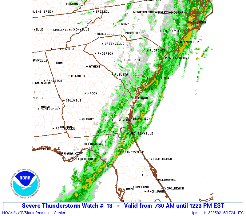
Severe Thunderstorm Watch Number 13
NWS Storm Prediction Center Norman OK
730 AM EST Sun Feb 16 2025
The NWS Storm Prediction Center has issued a
* Severe Thunderstorm Watch for portions of
North Florida
Southeast/Coastal Georgia
Southern/Coastal South Carolina
Coastal Waters
* Effective this Sunday morning and afternoon from 730 AM until
100 PM EST.
* Primary threats include...
Scattered damaging wind gusts to 70 mph possible
A tornado or two possible
SUMMARY...A line of thunderstorms will continue to move
east-southeastward to the Atlantic Coast this morning. Occasional
strong to damaging winds should be the main threat with this
activity, although a brief tornado may also occur.
The severe thunderstorm watch area is approximately along and 60
statute miles east and west of a line from 25 miles northwest of
Charleston SC to 40 miles west of Jacksonville FL. For a complete
depiction of the watch see the associated watch outline update
(WOUS64 KWNS WOU3).
PRECAUTIONARY/PREPAREDNESS ACTIONS...
REMEMBER...A Severe Thunderstorm Watch means conditions are
favorable for severe thunderstorms in and close to the watch area.
Persons in these areas should be on the lookout for threatening
weather conditions and listen for later statements and possible
warnings. Severe thunderstorms can and occasionally do produce
tornadoes.
&&
OTHER WATCH INFORMATION...CONTINUE...WW 11...WW 12...
AVIATION...A few severe thunderstorms with hail surface and aloft to
0.5 inches. Extreme turbulence and surface wind gusts to 60 knots. A
few cumulonimbi with maximum tops to 400. Mean storm motion vector
28040.
...Gleason

SEL3
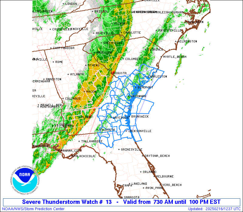
URGENT - IMMEDIATE BROADCAST REQUESTED
Severe Thunderstorm Watch Number 13
NWS Storm Prediction Center Norman OK
730 AM EST Sun Feb 16 2025
The NWS Storm Prediction Center has issued a
* Severe Thunderstorm Watch for portions of
North Florida
Southeast/Coastal Georgia
Southern/Coastal South Carolina
Coastal Waters
* Effective this Sunday morning and afternoon from 730 AM until
100 PM EST.
* Primary threats include...
Scattered damaging wind gusts to 70 mph possible
A tornado or two possible
SUMMARY...A line of thunderstorms will continue to move
east-southeastward to the Atlantic Coast this morning. Occasional
strong to damaging winds should be the main threat with this
activity, although a brief tornado may also occur.
The severe thunderstorm watch area is approximately along and 60
statute miles east and west of a line from 25 miles northwest of
Charleston SC to 40 miles west of Jacksonville FL. For a complete
depiction of the watch see the associated watch outline update
(WOUS64 KWNS WOU3).
PRECAUTIONARY/PREPAREDNESS ACTIONS...
REMEMBER...A Severe Thunderstorm Watch means conditions are
favorable for severe thunderstorms in and close to the watch area.
Persons in these areas should be on the lookout for threatening
weather conditions and listen for later statements and possible
warnings. Severe thunderstorms can and occasionally do produce
tornadoes.
&&
OTHER WATCH INFORMATION...CONTINUE...WW 11...WW 12...
AVIATION...A few severe thunderstorms with hail surface and aloft to
0.5 inches. Extreme turbulence and surface wind gusts to 60 knots. A
few cumulonimbi with maximum tops to 400. Mean storm motion vector
28040.
...Gleason
 Note:
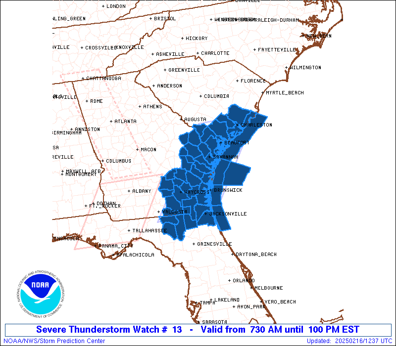
The Aviation Watch (SAW) product is an approximation to the watch area.
The actual watch is depicted by the shaded areas.
Note:
The Aviation Watch (SAW) product is an approximation to the watch area.
The actual watch is depicted by the shaded areas.
   SAW3
   WW 13 SEVERE TSTM FL GA SC CW 161230Z - 161800Z
   AXIS..60 STATUTE MILES EAST AND WEST OF LINE..
   25NW CHS/CHARLESTON SC/ - 40W JAX/JACKSONVILLE FL/
   ..AVIATION COORDS.. 50NM E/W /22NW CHS - 45WNW CRG/
   HAIL SURFACE AND ALOFT..0.5 INCH. WIND GUSTS..60 KNOTS.
   MAX TOPS TO 400. MEAN STORM MOTION VECTOR 28040.

   LAT...LON 33157930 30498133 30498336 33158137

   THIS IS AN APPROXIMATION TO THE WATCH AREA.  FOR A
   COMPLETE DEPICTION OF THE WATCH SEE WOUS64 KWNS
   FOR WOU3.
Watch 13 Status Report Messages:
STATUS REPORT #8 ON WW 13

VALID 161635Z - 161740Z

SEVERE WEATHER THREAT CONTINUES RIGHT OF A LINE FROM 5 NW JAX TO
40 E SSI.

..KERR..02/16/25

ATTN...WFO...JAX...CHS...

&&

STATUS REPORT FOR WS 13

SEVERE WEATHER THREAT CONTINUES FOR THE FOLLOWING AREAS

FLC031-161740-

FL
.    FLORIDA COUNTIES INCLUDED ARE

DUVAL
$$


AMZ350-374-452-161740-

CW

.    ADJACENT COASTAL WATERS INCLUDED ARE

COASTAL WATERS FROM SOUTH SANTEE RIVER TO EDISTO BEACH SC OUT 20
NM

WATERS FROM SAVANNAH GA TO ALTAMAHA SOUND GA EXTENDING FROM 20 NM
TO 60 NM

COASTAL WATERS FROM FERNANDINA BEACH TO ST. AUGUSTINE FL OUT 20
NM

$$
THE WATCH STATUS MESSAGE IS FOR GUIDANCE PURPOSES ONLY.  PLEASE
REFER TO WATCH COUNTY NOTIFICATION STATEMENTS FOR OFFICIAL
INFORMATION ON COUNTIES...INDEPENDENT CITIES AND MARINE ZONES
CLEARED FROM SEVERE THUNDERSTORM AND TORNADO WATCHES.
$$

STATUS REPORT #7 ON WW 13

VALID 161610Z - 161740Z

SEVERE WEATHER THREAT CONTINUES RIGHT OF A LINE FROM 25 W JAX TO
15 E SSI TO 50 ESE SAV TO 20 SSE CHS TO 35 ENE CHS.

..KERR..02/16/25

ATTN...WFO...JAX...CHS...

&&

STATUS REPORT FOR WS 13

SEVERE WEATHER THREAT CONTINUES FOR THE FOLLOWING AREAS

FLC031-089-161740-

FL
.    FLORIDA COUNTIES INCLUDED ARE

DUVAL		     NASSAU
$$


AMZ350-374-450-452-161740-

CW

.    ADJACENT COASTAL WATERS INCLUDED ARE

COASTAL WATERS FROM SOUTH SANTEE RIVER TO EDISTO BEACH SC OUT 20
NM

WATERS FROM SAVANNAH GA TO ALTAMAHA SOUND GA EXTENDING FROM 20 NM
TO 60 NM

COASTAL WATERS FROM ALTAMAHA SOUND TO FERNANDINA BEACH FL OUT 20
NM

COASTAL WATERS FROM FERNANDINA BEACH TO ST. AUGUSTINE FL OUT 20
NM

$$
THE WATCH STATUS MESSAGE IS FOR GUIDANCE PURPOSES ONLY.  PLEASE
REFER TO WATCH COUNTY NOTIFICATION STATEMENTS FOR OFFICIAL
INFORMATION ON COUNTIES...INDEPENDENT CITIES AND MARINE ZONES
CLEARED FROM SEVERE THUNDERSTORM AND TORNADO WATCHES.
$$

STATUS REPORT #6 ON WW 13

VALID 161545Z - 161640Z

SEVERE WEATHER THREAT CONTINUES RIGHT OF A LINE FROM 40 W JAX TO
10 ESE SSI TO 45 SSW CHS TO 25 NE CHS.

..KERR..02/16/25

ATTN...WFO...JAX...CHS...

&&

STATUS REPORT FOR WS 13

SEVERE WEATHER THREAT CONTINUES FOR THE FOLLOWING AREAS

FLC031-089-161640-

FL
.    FLORIDA COUNTIES INCLUDED ARE

DUVAL		     NASSAU
$$


GAC039-049-191-161640-

GA
.    GEORGIA COUNTIES INCLUDED ARE

CAMDEN		     CHARLTON		 MCINTOSH
$$


AMZ350-352-354-374-450-452-161640-

CW

.    ADJACENT COASTAL WATERS INCLUDED ARE

COASTAL WATERS FROM SOUTH SANTEE RIVER TO EDISTO BEACH SC OUT 20
NM

COASTAL WATERS FROM EDISTO BEACH SC TO SAVANNAH GA OUT 20 NM

COASTAL WATERS FROM SAVANNAH GA TO ALTAMAHA SOUND GA OUT 20 NM
...INCLUDING GRAYS REEF NATIONAL MARINE SANCTUARY

WATERS FROM SAVANNAH GA TO ALTAMAHA SOUND GA EXTENDING FROM 20 NM
TO 60 NM

COASTAL WATERS FROM ALTAMAHA SOUND TO FERNANDINA BEACH FL OUT 20
NM

COASTAL WATERS FROM FERNANDINA BEACH TO ST. AUGUSTINE FL OUT 20
NM

$$
THE WATCH STATUS MESSAGE IS FOR GUIDANCE PURPOSES ONLY.  PLEASE
REFER TO WATCH COUNTY NOTIFICATION STATEMENTS FOR OFFICIAL
INFORMATION ON COUNTIES...INDEPENDENT CITIES AND MARINE ZONES
CLEARED FROM SEVERE THUNDERSTORM AND TORNADO WATCHES.
$$

STATUS REPORT #5 ON WW 13

VALID 161535Z - 161640Z

SEVERE WEATHER THREAT CONTINUES RIGHT OF A LINE FROM 40 W JAX TO
30 NNE SSI TO 20 N CHS.

..KERR..02/16/25

ATTN...WFO...JAX...CHS...

&&

STATUS REPORT FOR WS 13

SEVERE WEATHER THREAT CONTINUES FOR THE FOLLOWING AREAS

FLC031-089-161640-

FL
.    FLORIDA COUNTIES INCLUDED ARE

DUVAL		     NASSAU
$$


GAC039-049-127-191-161640-

GA
.    GEORGIA COUNTIES INCLUDED ARE

CAMDEN		     CHARLTON		 GLYNN
MCINTOSH
$$


SCC015-019-161640-

SC
.    SOUTH CAROLINA COUNTIES INCLUDED ARE

BERKELEY	     CHARLESTON
$$


AMZ330-350-352-354-374-450-452-161640-

CW

.    ADJACENT COASTAL WATERS INCLUDED ARE

CHARLESTON HARBOR

COASTAL WATERS FROM SOUTH SANTEE RIVER TO EDISTO BEACH SC OUT 20
NM

COASTAL WATERS FROM EDISTO BEACH SC TO SAVANNAH GA OUT 20 NM

COASTAL WATERS FROM SAVANNAH GA TO ALTAMAHA SOUND GA OUT 20 NM
...INCLUDING GRAYS REEF NATIONAL MARINE SANCTUARY

WATERS FROM SAVANNAH GA TO ALTAMAHA SOUND GA EXTENDING FROM 20 NM
TO 60 NM

COASTAL WATERS FROM ALTAMAHA SOUND TO FERNANDINA BEACH FL OUT 20
NM

COASTAL WATERS FROM FERNANDINA BEACH TO ST. AUGUSTINE FL OUT 20
NM

$$
THE WATCH STATUS MESSAGE IS FOR GUIDANCE PURPOSES ONLY.  PLEASE
REFER TO WATCH COUNTY NOTIFICATION STATEMENTS FOR OFFICIAL
INFORMATION ON COUNTIES...INDEPENDENT CITIES AND MARINE ZONES
CLEARED FROM SEVERE THUNDERSTORM AND TORNADO WATCHES.
$$

STATUS REPORT #4 ON WW 13

VALID 161515Z - 161640Z

SEVERE WEATHER THREAT CONTINUES RIGHT OF A LINE FROM 45 ESE VLD
TO 30 S SAV TO 25 NW CHS.

..KERR..02/16/25

ATTN...WFO...JAX...CHS...

&&

STATUS REPORT FOR WS 13

SEVERE WEATHER THREAT CONTINUES FOR THE FOLLOWING AREAS

FLC003-023-031-047-089-121-161640-

FL
.    FLORIDA COUNTIES INCLUDED ARE

BAKER		     COLUMBIA		 DUVAL
HAMILTON	     NASSAU		 SUWANNEE
$$


GAC039-049-051-127-191-161640-

GA
.    GEORGIA COUNTIES INCLUDED ARE

CAMDEN		     CHARLTON		 CHATHAM
GLYNN		     MCINTOSH
$$


SCC013-015-019-029-035-161640-

SC
.    SOUTH CAROLINA COUNTIES INCLUDED ARE

BEAUFORT	     BERKELEY		 CHARLESTON
COLLETON	     DORCHESTER
$$


AMZ330-350-352-354-374-450-452-161640-

CW

.    ADJACENT COASTAL WATERS INCLUDED ARE

CHARLESTON HARBOR

COASTAL WATERS FROM SOUTH SANTEE RIVER TO EDISTO BEACH SC OUT 20
NM

COASTAL WATERS FROM EDISTO BEACH SC TO SAVANNAH GA OUT 20 NM

COASTAL WATERS FROM SAVANNAH GA TO ALTAMAHA SOUND GA OUT 20 NM
...INCLUDING GRAYS REEF NATIONAL MARINE SANCTUARY

WATERS FROM SAVANNAH GA TO ALTAMAHA SOUND GA EXTENDING FROM 20 NM
TO 60 NM

COASTAL WATERS FROM ALTAMAHA SOUND TO FERNANDINA BEACH FL OUT 20
NM

COASTAL WATERS FROM FERNANDINA BEACH TO ST. AUGUSTINE FL OUT 20
NM

$$
THE WATCH STATUS MESSAGE IS FOR GUIDANCE PURPOSES ONLY.  PLEASE
REFER TO WATCH COUNTY NOTIFICATION STATEMENTS FOR OFFICIAL
INFORMATION ON COUNTIES...INDEPENDENT CITIES AND MARINE ZONES
CLEARED FROM SEVERE THUNDERSTORM AND TORNADO WATCHES.
$$

STATUS REPORT #3 ON WW 13

VALID 161500Z - 161640Z

SEVERE WEATHER THREAT CONTINUES RIGHT OF A LINE FROM 35 SE VLD TO
25 ESE AYS TO 20 NE SAV TO 25 NW CHS.

..KERR..02/16/25

ATTN...WFO...JAX...CHS...

&&

STATUS REPORT FOR WS 13

SEVERE WEATHER THREAT CONTINUES FOR THE FOLLOWING AREAS

FLC003-023-031-047-089-121-161640-

FL
.    FLORIDA COUNTIES INCLUDED ARE

BAKER		     COLUMBIA		 DUVAL
HAMILTON	     NASSAU		 SUWANNEE
$$


GAC025-039-049-051-101-127-179-183-191-305-161640-

GA
.    GEORGIA COUNTIES INCLUDED ARE

BRANTLEY	     CAMDEN		 CHARLTON
CHATHAM 	     ECHOLS		 GLYNN
LIBERTY 	     LONG		 MCINTOSH
WAYNE
$$


SCC013-015-019-029-035-161640-

SC
.    SOUTH CAROLINA COUNTIES INCLUDED ARE

BEAUFORT	     BERKELEY		 CHARLESTON
COLLETON	     DORCHESTER
$$


AMZ330-350-352-354-374-450-452-161640-

CW

.    ADJACENT COASTAL WATERS INCLUDED ARE

CHARLESTON HARBOR

COASTAL WATERS FROM SOUTH SANTEE RIVER TO EDISTO BEACH SC OUT 20
NM

COASTAL WATERS FROM EDISTO BEACH SC TO SAVANNAH GA OUT 20 NM

COASTAL WATERS FROM SAVANNAH GA TO ALTAMAHA SOUND GA OUT 20 NM
...INCLUDING GRAYS REEF NATIONAL MARINE SANCTUARY

WATERS FROM SAVANNAH GA TO ALTAMAHA SOUND GA EXTENDING FROM 20 NM
TO 60 NM

COASTAL WATERS FROM ALTAMAHA SOUND TO FERNANDINA BEACH FL OUT 20
NM

COASTAL WATERS FROM FERNANDINA BEACH TO ST. AUGUSTINE FL OUT 20
NM

$$
THE WATCH STATUS MESSAGE IS FOR GUIDANCE PURPOSES ONLY.  PLEASE
REFER TO WATCH COUNTY NOTIFICATION STATEMENTS FOR OFFICIAL
INFORMATION ON COUNTIES...INDEPENDENT CITIES AND MARINE ZONES
CLEARED FROM SEVERE THUNDERSTORM AND TORNADO WATCHES.
$$

STATUS REPORT #2 ON WW 13

VALID 161430Z - 161540Z

SEVERE WEATHER THREAT CONTINUES RIGHT OF A LINE FROM 10 S VLD TO
15 W SAV TO 20 SSE OGB.

..KERR..02/16/25

ATTN...WFO...JAX...CHS...

&&

STATUS REPORT FOR WS 13

SEVERE WEATHER THREAT CONTINUES FOR THE FOLLOWING AREAS

FLC003-023-031-047-089-121-161540-

FL
.    FLORIDA COUNTIES INCLUDED ARE

BAKER		     COLUMBIA		 DUVAL
HAMILTON	     NASSAU		 SUWANNEE
$$


GAC005-025-029-039-049-051-065-101-103-127-179-183-191-229-299-
305-161540-

GA
.    GEORGIA COUNTIES INCLUDED ARE

BACON		     BRANTLEY		 BRYAN
CAMDEN		     CHARLTON		 CHATHAM
CLINCH		     ECHOLS		 EFFINGHAM
GLYNN		     LIBERTY		 LONG
MCINTOSH	     PIERCE		 WARE
WAYNE
$$


SCC013-015-019-029-035-049-053-161540-

SC
.    SOUTH CAROLINA COUNTIES INCLUDED ARE

BEAUFORT	     BERKELEY		 CHARLESTON
COLLETON	     DORCHESTER 	 HAMPTON
JASPER
$$


AMZ330-350-352-354-374-450-452-161540-

CW

.    ADJACENT COASTAL WATERS INCLUDED ARE

CHARLESTON HARBOR

COASTAL WATERS FROM SOUTH SANTEE RIVER TO EDISTO BEACH SC OUT 20
NM

COASTAL WATERS FROM EDISTO BEACH SC TO SAVANNAH GA OUT 20 NM

COASTAL WATERS FROM SAVANNAH GA TO ALTAMAHA SOUND GA OUT 20 NM
...INCLUDING GRAYS REEF NATIONAL MARINE SANCTUARY

WATERS FROM SAVANNAH GA TO ALTAMAHA SOUND GA EXTENDING FROM 20 NM
TO 60 NM

COASTAL WATERS FROM ALTAMAHA SOUND TO FERNANDINA BEACH FL OUT 20
NM

COASTAL WATERS FROM FERNANDINA BEACH TO ST. AUGUSTINE FL OUT 20
NM

$$
THE WATCH STATUS MESSAGE IS FOR GUIDANCE PURPOSES ONLY.  PLEASE
REFER TO WATCH COUNTY NOTIFICATION STATEMENTS FOR OFFICIAL
INFORMATION ON COUNTIES...INDEPENDENT CITIES AND MARINE ZONES
CLEARED FROM SEVERE THUNDERSTORM AND TORNADO WATCHES.
$$

STATUS REPORT #1 ON WW 13

VALID 161345Z - 161440Z

THE SEVERE WEATHER THREAT CONTINUES ACROSS THE ENTIRE WATCH AREA.

..GLEASON..02/16/25

ATTN...WFO...JAX...CHS...

&&

STATUS REPORT FOR WS 13

SEVERE WEATHER THREAT CONTINUES FOR THE FOLLOWING AREAS

FLC003-023-031-047-089-121-161440-

FL
.    FLORIDA COUNTIES INCLUDED ARE

BAKER		     COLUMBIA		 DUVAL
HAMILTON	     NASSAU		 SUWANNEE
$$


GAC001-003-005-025-029-031-039-043-049-051-065-069-101-103-109-
127-161-165-179-183-191-229-251-267-299-305-161440-

GA
.    GEORGIA COUNTIES INCLUDED ARE

APPLING 	     ATKINSON		 BACON
BRANTLEY	     BRYAN		 BULLOCH
CAMDEN		     CANDLER		 CHARLTON
CHATHAM 	     CLINCH		 COFFEE
ECHOLS		     EFFINGHAM		 EVANS
GLYNN		     JEFF DAVIS 	 JENKINS
LIBERTY 	     LONG		 MCINTOSH
PIERCE		     SCREVEN		 TATTNALL
WARE		     WAYNE
$$


SCC005-013-015-019-029-035-049-053-161440-

SC
.    SOUTH CAROLINA COUNTIES INCLUDED ARE

ALLENDALE	     BEAUFORT		 BERKELEY
CHARLESTON	     COLLETON		 DORCHESTER
HAMPTON 	     JASPER
$$


AMZ330-350-352-354-374-450-452-161440-

CW

.    ADJACENT COASTAL WATERS INCLUDED ARE

CHARLESTON HARBOR

COASTAL WATERS FROM SOUTH SANTEE RIVER TO EDISTO BEACH SC OUT 20
NM

COASTAL WATERS FROM EDISTO BEACH SC TO SAVANNAH GA OUT 20 NM

COASTAL WATERS FROM SAVANNAH GA TO ALTAMAHA SOUND GA OUT 20 NM
...INCLUDING GRAYS REEF NATIONAL MARINE SANCTUARY

WATERS FROM SAVANNAH GA TO ALTAMAHA SOUND GA EXTENDING FROM 20 NM
TO 60 NM

COASTAL WATERS FROM ALTAMAHA SOUND TO FERNANDINA BEACH FL OUT 20
NM

COASTAL WATERS FROM FERNANDINA BEACH TO ST. AUGUSTINE FL OUT 20
NM

$$
THE WATCH STATUS MESSAGE IS FOR GUIDANCE PURPOSES ONLY.  PLEASE
REFER TO WATCH COUNTY NOTIFICATION STATEMENTS FOR OFFICIAL
INFORMATION ON COUNTIES...INDEPENDENT CITIES AND MARINE ZONES
CLEARED FROM SEVERE THUNDERSTORM AND TORNADO WATCHES.
$$
Note:
Click for Complete Product Text.
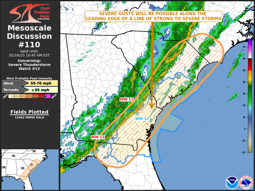
Tornadoes
Probability of 2 or more tornadoes
|
Low (20%)
|
Probability of 1 or more strong (EF2-EF5) tornadoes
|
Low (<2%)
|
Wind
Probability of 10 or more severe wind events
|
Mod (40%)
|
Probability of 1 or more wind events > 65 knots
|
Low (10%)
|
Hail
Probability of 10 or more severe hail events
|
Low (<5%)
|
Probability of 1 or more hailstones > 2 inches
|
Low (<5%)
|
Combined Severe Hail/Wind
Probability of 6 or more combined severe hail/wind events
|
Mod (50%)
|
For each watch, probabilities for particular events inside the watch
(listed above in each table) are determined by the issuing forecaster.
The "Low" category contains probability values ranging from less than 2%
to 20% (EF2-EF5 tornadoes), less than 5% to 20% (all other probabilities),
"Moderate" from 30% to 60%, and "High" from 70% to greater than 95%.
High values are bolded and lighter in color to provide awareness of
an increased threat for a particular event.


 @NWSSPC