 Note:
The expiration time in the watch graphic is amended if the watch is
replaced, cancelled or extended.
Note:
Note:
The expiration time in the watch graphic is amended if the watch is
replaced, cancelled or extended.
Note: Click for
Watch Status Reports.
SEL1
URGENT - IMMEDIATE BROADCAST REQUESTED
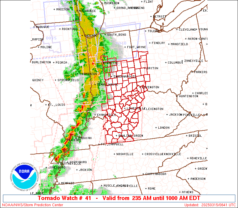
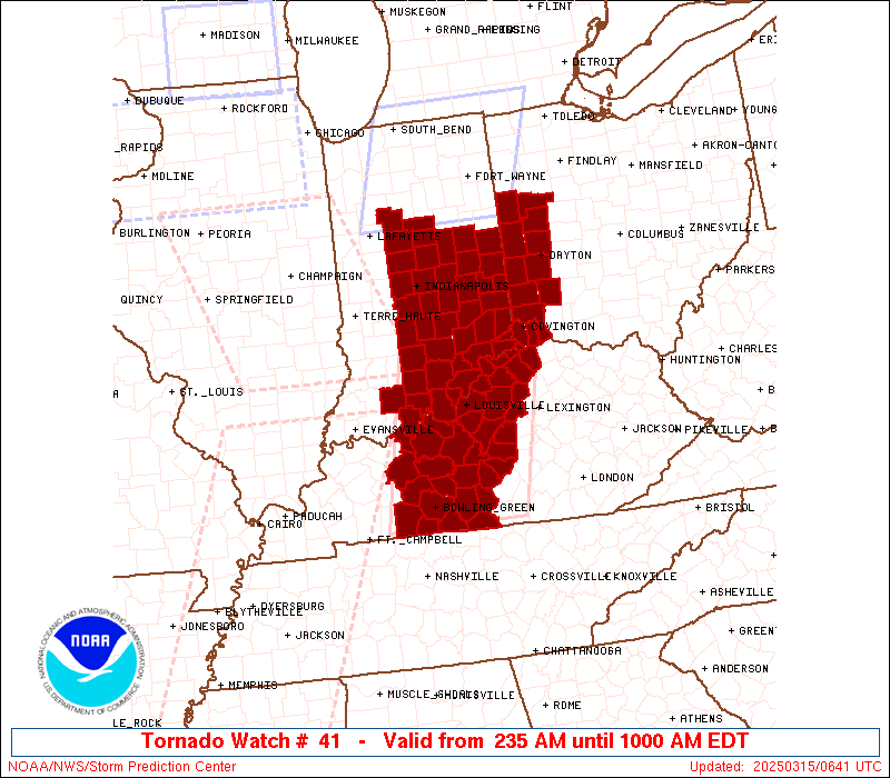
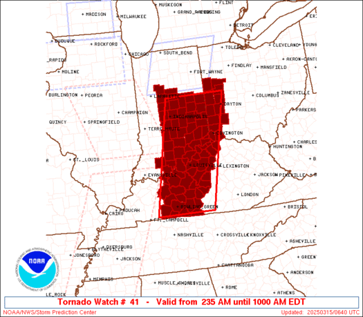
Tornado Watch Number 41
NWS Storm Prediction Center Norman OK
235 AM EDT Sat Mar 15 2025
The NWS Storm Prediction Center has issued a
* Tornado Watch for portions of
Central and Southern Indiana
Central Kentucky
Western Ohio
* Effective this Saturday morning from 235 AM until 1000 AM EDT.
* Primary threats include...
A couple tornadoes possible
Scattered damaging winds and isolated significant gusts to 75
mph likely
Isolated large hail events to 1 inch in diameter possible
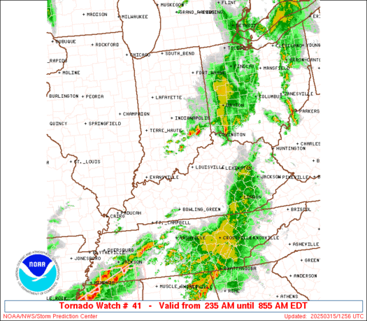
SUMMARY...A broken band of thunderstorms with embedded supercells
and bowing segments will move east across the Watch area during the
overnight into the early morning. Damaging gusts and tornadoes will
be the primary hazards with the stronger storms.
The tornado watch area is approximately along and 60 statute miles
east and west of a line from 10 miles east northeast of Muncie IN to
25 miles southeast of Bowling Green KY. For a complete depiction of
the watch see the associated watch outline update (WOUS64 KWNS
WOU1).
PRECAUTIONARY/PREPAREDNESS ACTIONS...
REMEMBER...A Tornado Watch means conditions are favorable for
tornadoes and severe thunderstorms in and close to the watch
area. Persons in these areas should be on the lookout for
threatening weather conditions and listen for later statements
and possible warnings.
&&
OTHER WATCH INFORMATION...CONTINUE...WW 35...WW 36...WW 37...WW
38...WW 39...WW 40...
AVIATION...Tornadoes and a few severe thunderstorms with hail
surface and aloft to 1 inch. Extreme turbulence and surface wind
gusts to 65 knots. A few cumulonimbi with maximum tops to 400. Mean
storm motion vector 22055.
...Smith
 Note:
The Aviation Watch (SAW) product is an approximation to the watch area.
The actual watch is depicted by the shaded areas.
Note:
The Aviation Watch (SAW) product is an approximation to the watch area.
The actual watch is depicted by the shaded areas.
   SAW1
   WW 41 TORNADO IN KY OH 150635Z - 151400Z
   AXIS..60 STATUTE MILES EAST AND WEST OF LINE..
   10ENE MIE/MUNCIE IN/ - 25SE BWG/BOWLING GREEN KY/
   ..AVIATION COORDS.. 50NM E/W /41S FWA - 21SE BWG/
   HAIL SURFACE AND ALOFT..1 INCH. WIND GUSTS..65 KNOTS.
   MAX TOPS TO 400. MEAN STORM MOTION VECTOR 22055.

   LAT...LON 40308409 36718502 36718718 40308636

   THIS IS AN APPROXIMATION TO THE WATCH AREA.  FOR A
   COMPLETE DEPICTION OF THE WATCH SEE WOUS64 KWNS
   FOR WOU1.
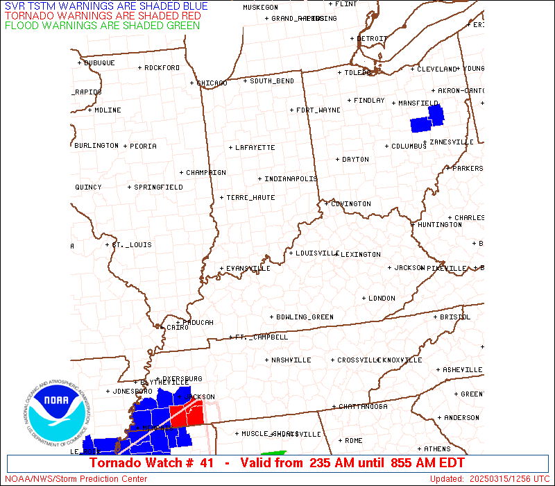
Watch 41 Status Report Messages:
STATUS REPORT #3 ON WW 41

VALID 151225Z - 151400Z

SEVERE WEATHER THREAT CONTINUES RIGHT OF A LINE FROM 5 N LEX TO
35 ENE SDF TO 35 WSW LUK TO 10 NE LUK.

WW 41 WILL BE ALLOWED TO EXPIRE AT 151400Z.

..SQUITIERI..03/15/25

ATTN...WFO...IND...LMK...ILN...

&&

STATUS REPORT FOR WT 41

SEVERE WEATHER THREAT CONTINUES FOR THE FOLLOWING AREAS

KYC015-037-077-081-117-187-151400-

KY
.    KENTUCKY COUNTIES INCLUDED ARE

BOONE		     CAMPBELL		 GALLATIN
GRANT		     KENTON		 OWEN
$$


THE WATCH STATUS MESSAGE IS FOR GUIDANCE PURPOSES ONLY.  PLEASE
REFER TO WATCH COUNTY NOTIFICATION STATEMENTS FOR OFFICIAL
INFORMATION ON COUNTIES...INDEPENDENT CITIES AND MARINE ZONES
CLEARED FROM SEVERE THUNDERSTORM AND TORNADO WATCHES.
$$

STATUS REPORT #2 ON WW 41

VALID 151130Z - 151240Z

SEVERE WEATHER THREAT CONTINUES RIGHT OF A LINE FROM 25 N BNA TO
25 WNW SDF TO 55 W LUK TO 25 NNW LUK TO 15 ESE DAY.

..SQUITIERI..03/15/25

ATTN...WFO...IND...LMK...ILN...

&&

STATUS REPORT FOR WT 41

SEVERE WEATHER THREAT CONTINUES FOR THE FOLLOWING AREAS

INC019-029-043-061-077-079-115-137-143-155-151240-

IN
.    INDIANA COUNTIES INCLUDED ARE

CLARK		     DEARBORN		 FLOYD
HARRISON	     JEFFERSON		 JENNINGS
OHIO		     RIPLEY		 SCOTT
SWITZERLAND
$$


KYC003-005-009-015-029-037-041-061-073-077-081-087-093-099-103-
111-117-123-155-163-169-171-179-185-187-211-215-217-223-227-229-
151240-

KY
.    KENTUCKY COUNTIES INCLUDED ARE

ALLEN		     ANDERSON		 BARREN
BOONE		     BULLITT		 CAMPBELL
CARROLL 	     EDMONSON		 FRANKLIN
GALLATIN	     GRANT		 GREEN
HARDIN		     HART		 HENRY
JEFFERSON	     KENTON		 LARUE
MARION		     MEADE		 METCALFE
MONROE		     NELSON		 OLDHAM
OWEN		     SHELBY		 SPENCER
TAYLOR		     TRIMBLE		 WARREN
WASHINGTON
$$


OHC165-151240-

OH
.    OHIO COUNTIES INCLUDED ARE

WARREN
$$


THE WATCH STATUS MESSAGE IS FOR GUIDANCE PURPOSES ONLY.  PLEASE
REFER TO WATCH COUNTY NOTIFICATION STATEMENTS FOR OFFICIAL
INFORMATION ON COUNTIES...INDEPENDENT CITIES AND MARINE ZONES
CLEARED FROM SEVERE THUNDERSTORM AND TORNADO WATCHES.
$$

STATUS REPORT #1 ON WW 41

VALID 150750Z - 150840Z

SEVERE WEATHER THREAT CONTINUES RIGHT OF A LINE FROM 20 E HUF TO
30 ENE LAF TO 40 SSE VPZ.

..MOORE..03/15/25

ATTN...WFO...IND...LMK...ILN...

&&

STATUS REPORT FOR WT 41

SEVERE WEATHER THREAT CONTINUES FOR THE FOLLOWING AREAS

INC005-011-013-019-023-025-029-031-035-037-041-043-047-057-059-
061-063-065-067-071-077-079-081-093-095-097-105-109-115-117-123-
135-137-139-143-145-155-159-161-175-177-150840-

IN
.    INDIANA COUNTIES INCLUDED ARE

BARTHOLOMEW	     BOONE		 BROWN
CLARK		     CLINTON		 CRAWFORD
DEARBORN	     DECATUR		 DELAWARE
DUBOIS		     FAYETTE		 FLOYD
FRANKLIN	     HAMILTON		 HANCOCK
HARRISON	     HENDRICKS		 HENRY
HOWARD		     JACKSON		 JEFFERSON
JENNINGS	     JOHNSON		 LAWRENCE
MADISON 	     MARION		 MONROE
MORGAN		     OHIO		 ORANGE
PERRY		     RANDOLPH		 RIPLEY
RUSH		     SCOTT		 SHELBY
SWITZERLAND	     TIPTON		 UNION
WASHINGTON	     WAYNE
$$


KYC003-005-009-015-027-029-031-037-041-061-073-077-081-085-087-
091-093-099-103-111-117-123-141-155-163-169-171-179-183-185-187-
211-213-215-217-223-227-229-150840-

KY
.    KENTUCKY COUNTIES INCLUDED ARE

ALLEN		     ANDERSON		 BARREN
BOONE		     BRECKINRIDGE	 BULLITT
BUTLER		     CAMPBELL		 CARROLL
EDMONSON	     FRANKLIN		 GALLATIN
GRANT		     GRAYSON		 GREEN
HANCOCK 	     HARDIN		 HART
HENRY		     JEFFERSON		 KENTON
LARUE		     LOGAN		 MARION
MEADE		     METCALFE		 MONROE
NELSON		     OHIO		 OLDHAM
OWEN		     SHELBY		 SIMPSON
SPENCER 	     TAYLOR		 TRIMBLE
WARREN		     WASHINGTON
$$


OHC011-017-037-061-107-109-113-135-149-165-150840-

OH
.    OHIO COUNTIES INCLUDED ARE

AUGLAIZE	     BUTLER		 DARKE
HAMILTON	     MERCER		 MIAMI
MONTGOMERY	     PREBLE		 SHELBY
WARREN
$$


THE WATCH STATUS MESSAGE IS FOR GUIDANCE PURPOSES ONLY.  PLEASE
REFER TO WATCH COUNTY NOTIFICATION STATEMENTS FOR OFFICIAL
INFORMATION ON COUNTIES...INDEPENDENT CITIES AND MARINE ZONES
CLEARED FROM SEVERE THUNDERSTORM AND TORNADO WATCHES.
$$
Note:
Click for Complete Product Text.
Tornadoes
Probability of 2 or more tornadoes
|
Mod (40%)
|
Probability of 1 or more strong (EF2-EF5) tornadoes
|
Low (20%)
|
Wind
Probability of 10 or more severe wind events
|
Mod (60%)
|
Probability of 1 or more wind events > 65 knots
|
Mod (60%)
|
Hail
Probability of 10 or more severe hail events
|
Low (20%)
|
Probability of 1 or more hailstones > 2 inches
|
Low (20%)
|
Combined Severe Hail/Wind
Probability of 6 or more combined severe hail/wind events
|
High (80%)
|
For each watch, probabilities for particular events inside the watch
(listed above in each table) are determined by the issuing forecaster.
The "Low" category contains probability values ranging from less than 2%
to 20% (EF2-EF5 tornadoes), less than 5% to 20% (all other probabilities),
"Moderate" from 30% to 60%, and "High" from 70% to greater than 95%.
High values are bolded and lighter in color to provide awareness of
an increased threat for a particular event.


 @NWSSPC