 Note:
The expiration time in the watch graphic is amended if the watch is
replaced, cancelled or extended.
Note:
Note:
The expiration time in the watch graphic is amended if the watch is
replaced, cancelled or extended.
Note: Click for
Watch Status Reports.
SEL0
URGENT - IMMEDIATE BROADCAST REQUESTED
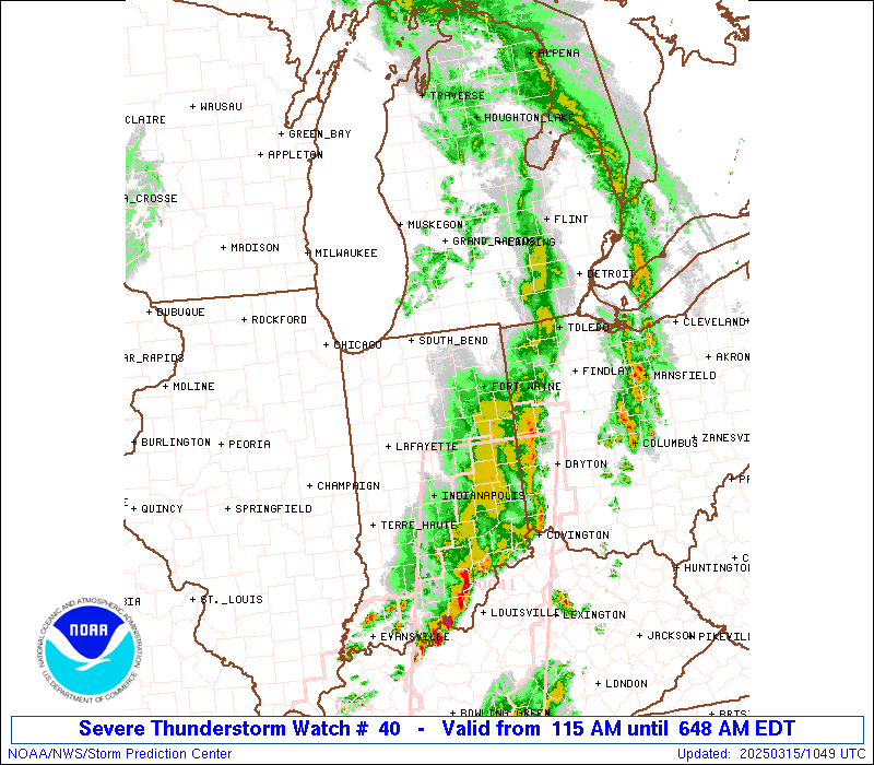
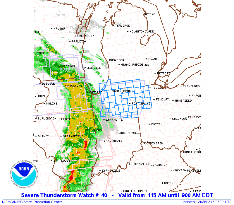
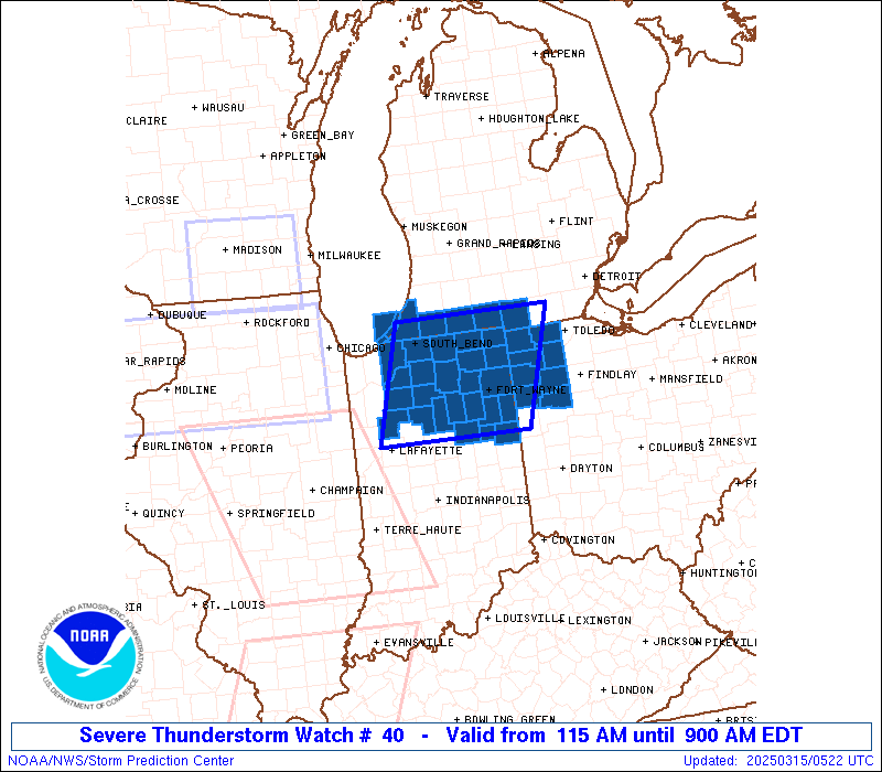
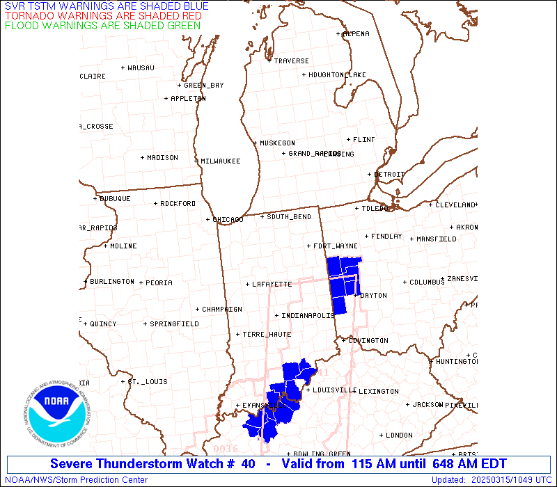
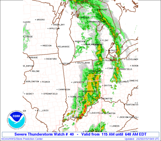
Severe Thunderstorm Watch Number 40
NWS Storm Prediction Center Norman OK
115 AM EDT Sat Mar 15 2025
The NWS Storm Prediction Center has issued a
* Severe Thunderstorm Watch for portions of
Northern Indiana
Far Southern Michigan
Far Northwest Ohio
Lake Michigan
* Effective this Saturday morning from 115 AM until 900 AM EDT.
* Primary threats include...
Scattered damaging wind gusts to 70 mph possible
Scattered large hail events to 1 inch in diameter possible
A tornado or two possible
SUMMARY...The threat for damaging wind gusts will likely continue
through the night as a line of thunderstorms moves across the
region.
The severe thunderstorm watch area is approximately along and 65
statute miles east and west of a line from 55 miles east northeast
of South Bend IN to 50 miles southwest of Fort Wayne IN. For a
complete depiction of the watch see the associated watch outline
update (WOUS64 KWNS WOU0).
PRECAUTIONARY/PREPAREDNESS ACTIONS...
REMEMBER...A Severe Thunderstorm Watch means conditions are
favorable for severe thunderstorms in and close to the watch area.
Persons in these areas should be on the lookout for threatening
weather conditions and listen for later statements and possible
warnings. Severe thunderstorms can and occasionally do produce
tornadoes.
&&
OTHER WATCH INFORMATION...CONTINUE...WW 35...WW 36...WW 37...WW
38...WW 39...
AVIATION...A few severe thunderstorms with hail surface and aloft to
1 inch. Extreme turbulence and surface wind gusts to 60 knots. A few
cumulonimbi with maximum tops to 500. Mean storm motion vector
24035.
...Mosier
 Note:
The Aviation Watch (SAW) product is an approximation to the watch area.
The actual watch is depicted by the shaded areas.
Note:
The Aviation Watch (SAW) product is an approximation to the watch area.
The actual watch is depicted by the shaded areas.
   SAW0
   WW 40 SEVERE TSTM IN MI OH LM 150515Z - 151300Z
   AXIS..65 STATUTE MILES EAST AND WEST OF LINE..
   55ENE SBN/SOUTH BEND IN/ - 50SW FWA/FORT WAYNE IN/
   ..AVIATION COORDS.. 55NM E/W /45SE PMM - 43SW FWA/
   HAIL SURFACE AND ALOFT..1 INCH. WIND GUSTS..60 KNOTS.
   MAX TOPS TO 500. MEAN STORM MOTION VECTOR 24035.

   LAT...LON 41998406 40468462 40468709 41998660

   THIS IS AN APPROXIMATION TO THE WATCH AREA.  FOR A
   COMPLETE DEPICTION OF THE WATCH SEE WOUS64 KWNS
   FOR WOU0.
Watch 40 Status Report Messages:
STATUS REPORT #3 ON WW 40

VALID 150855Z - 150940Z

SEVERE WEATHER THREAT CONTINUES RIGHT OF A LINE FROM 20 NW MIE TO
20 SE AZO.

..THOMPSON..03/15/25

ATTN...WFO...IWX...

&&

STATUS REPORT FOR WS 40

SEVERE WEATHER THREAT CONTINUES FOR THE FOLLOWING AREAS

INC001-003-009-033-053-069-075-087-113-151-179-183-150940-

IN
.    INDIANA COUNTIES INCLUDED ARE

ADAMS		     ALLEN		 BLACKFORD
DE KALB 	     GRANT		 HUNTINGTON
JAY		     LAGRANGE		 NOBLE
STEUBEN 	     WELLS		 WHITLEY
$$


MIC023-059-150940-

MI
.    MICHIGAN COUNTIES INCLUDED ARE

BRANCH		     HILLSDALE
$$


OHC003-039-051-069-125-137-161-171-150940-

OH
.    OHIO COUNTIES INCLUDED ARE

ALLEN		     DEFIANCE		 FULTON
HENRY		     PAULDING		 PUTNAM
VAN WERT	     WILLIAMS
$$


THE WATCH STATUS MESSAGE IS FOR GUIDANCE PURPOSES ONLY.  PLEASE
REFER TO WATCH COUNTY NOTIFICATION STATEMENTS FOR OFFICIAL
INFORMATION ON COUNTIES...INDEPENDENT CITIES AND MARINE ZONES
CLEARED FROM SEVERE THUNDERSTORM AND TORNADO WATCHES.
$$

STATUS REPORT #2 ON WW 40

VALID 150745Z - 150840Z

SEVERE WEATHER THREAT CONTINUES RIGHT OF A LINE FROM 20 ESE LAF
TO 25 ESE VPZ TO 30 NNW VPZ.

..MOORE..03/15/25

ATTN...WFO...IWX...

&&

STATUS REPORT FOR WS 40

SEVERE WEATHER THREAT CONTINUES FOR THE FOLLOWING AREAS

INC001-003-009-017-033-039-049-053-069-075-085-087-091-099-103-
113-141-151-169-179-183-150840-

IN
.    INDIANA COUNTIES INCLUDED ARE

ADAMS		     ALLEN		 BLACKFORD
CASS		     DE KALB		 ELKHART
FULTON		     GRANT		 HUNTINGTON
JAY		     KOSCIUSKO		 LAGRANGE
LA PORTE	     MARSHALL		 MIAMI
NOBLE		     ST. JOSEPH 	 STEUBEN
WABASH		     WELLS		 WHITLEY
$$


MIC021-023-027-059-149-150840-

MI
.    MICHIGAN COUNTIES INCLUDED ARE

BERRIEN 	     BRANCH		 CASS
HILLSDALE	     ST. JOSEPH
$$


OHC003-039-051-069-125-137-161-171-150840-

OH
.    OHIO COUNTIES INCLUDED ARE

ALLEN		     DEFIANCE		 FULTON
HENRY		     PAULDING		 PUTNAM
VAN WERT	     WILLIAMS
$$


LMZ043-046-080-150840-

CW

.    ADJACENT COASTAL WATERS INCLUDED ARE

NEW BUFFALO MI TO ST JOSEPH MI

MICHIGAN CITY IN TO NEW BUFFALO MI

LAKE MICHIGAN MICHIGAN CITY IN TO ST. JOSEPH MI 5 NM OFFSHORE TO
MID-LINE OF LAKE.

$$
THE WATCH STATUS MESSAGE IS FOR GUIDANCE PURPOSES ONLY.  PLEASE
REFER TO WATCH COUNTY NOTIFICATION STATEMENTS FOR OFFICIAL
INFORMATION ON COUNTIES...INDEPENDENT CITIES AND MARINE ZONES
CLEARED FROM SEVERE THUNDERSTORM AND TORNADO WATCHES.
$$

STATUS REPORT #1 ON WW 40

VALID 150540Z - 150640Z

THE SEVERE WEATHER THREAT CONTINUES ACROSS THE ENTIRE WATCH AREA.

..GOSS..03/15/25

ATTN...WFO...IWX...

&&

STATUS REPORT FOR WS 40

SEVERE WEATHER THREAT CONTINUES FOR THE FOLLOWING AREAS

INC001-003-009-017-033-039-049-053-069-075-085-087-091-099-103-
113-131-141-149-151-169-179-181-183-150640-

IN
.    INDIANA COUNTIES INCLUDED ARE

ADAMS		     ALLEN		 BLACKFORD
CASS		     DE KALB		 ELKHART
FULTON		     GRANT		 HUNTINGTON
JAY		     KOSCIUSKO		 LAGRANGE
LA PORTE	     MARSHALL		 MIAMI
NOBLE		     PULASKI		 ST. JOSEPH
STARKE		     STEUBEN		 WABASH
WELLS		     WHITE		 WHITLEY
$$


MIC021-023-027-059-149-150640-

MI
.    MICHIGAN COUNTIES INCLUDED ARE

BERRIEN 	     BRANCH		 CASS
HILLSDALE	     ST. JOSEPH
$$


OHC003-039-051-069-125-137-161-171-150640-

OH
.    OHIO COUNTIES INCLUDED ARE

ALLEN		     DEFIANCE		 FULTON
HENRY		     PAULDING		 PUTNAM
VAN WERT	     WILLIAMS
$$


LMZ043-046-080-150640-

CW

.    ADJACENT COASTAL WATERS INCLUDED ARE

NEW BUFFALO MI TO ST JOSEPH MI

MICHIGAN CITY IN TO NEW BUFFALO MI

LAKE MICHIGAN MICHIGAN CITY IN TO ST. JOSEPH MI 5 NM OFFSHORE TO
MID-LINE OF LAKE.

$$
THE WATCH STATUS MESSAGE IS FOR GUIDANCE PURPOSES ONLY.  PLEASE
REFER TO WATCH COUNTY NOTIFICATION STATEMENTS FOR OFFICIAL
INFORMATION ON COUNTIES...INDEPENDENT CITIES AND MARINE ZONES
CLEARED FROM SEVERE THUNDERSTORM AND TORNADO WATCHES.
$$
Note:
Click for Complete Product Text.
Tornadoes
Probability of 2 or more tornadoes
|
Low (20%)
|
Probability of 1 or more strong (EF2-EF5) tornadoes
|
Low (5%)
|
Wind
Probability of 10 or more severe wind events
|
Mod (40%)
|
Probability of 1 or more wind events > 65 knots
|
Low (10%)
|
Hail
Probability of 10 or more severe hail events
|
Mod (40%)
|
Probability of 1 or more hailstones > 2 inches
|
Low (20%)
|
Combined Severe Hail/Wind
Probability of 6 or more combined severe hail/wind events
|
High (70%)
|
For each watch, probabilities for particular events inside the watch
(listed above in each table) are determined by the issuing forecaster.
The "Low" category contains probability values ranging from less than 2%
to 20% (EF2-EF5 tornadoes), less than 5% to 20% (all other probabilities),
"Moderate" from 30% to 60%, and "High" from 70% to greater than 95%.
High values are bolded and lighter in color to provide awareness of
an increased threat for a particular event.


 @NWSSPC