Note:
The expiration time in the watch graphic is amended if the watch is
replaced, cancelled or extended.
Note:
Note:
The expiration time in the watch graphic is amended if the watch is
replaced, cancelled or extended.
Note: Click for
Watch Status Reports.
SEL8
URGENT - IMMEDIATE BROADCAST REQUESTED
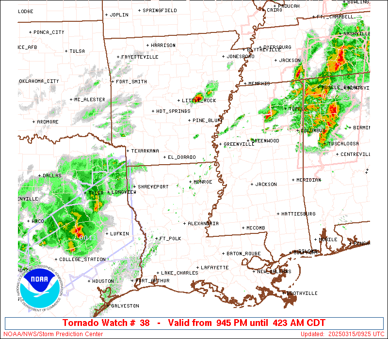
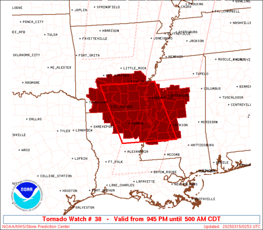
Tornado Watch Number 38
NWS Storm Prediction Center Norman OK
945 PM CDT Fri Mar 14 2025
The NWS Storm Prediction Center has issued a
* Tornado Watch for portions of
Southern Arkansas
Northeast Louisiana
Western Mississippi
* Effective this Friday night and Saturday morning from 945 PM
until 500 AM CDT.
* Primary threats include...
A few tornadoes likely with a couple intense tornadoes possible
Scattered large hail and isolated very large hail events to 2.5
inches in diameter possible
Scattered damaging wind gusts to 70 mph possible
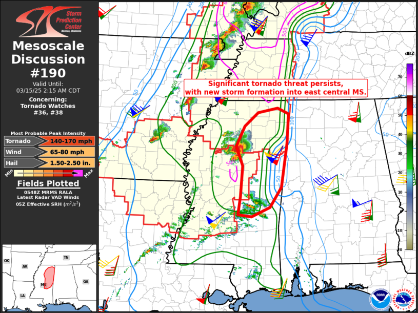
SUMMARY...The moist, unstable, and moderately to strongly sheared
airmass that exists over the region will remain supportive of
thunderstorms capable of all severe hazards, including a strong
(EF2+) tornado, for the next several hours.
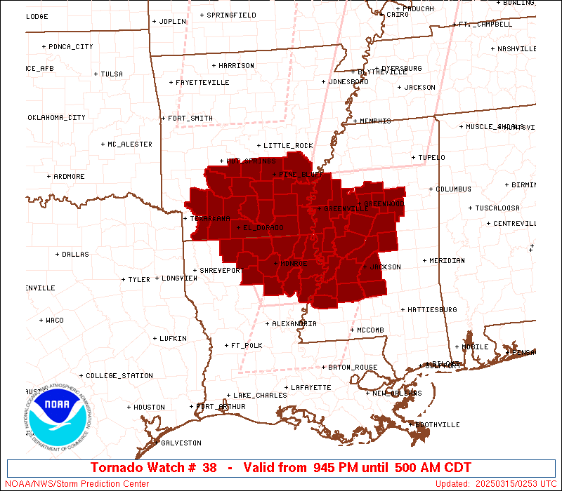
The tornado watch area is approximately along and 75 statute miles
east and west of a line from 75 miles southeast of Monroe LA to 35
miles north northwest of Monticello AR. For a complete depiction of
the watch see the associated watch outline update (WOUS64 KWNS
WOU8).
PRECAUTIONARY/PREPAREDNESS ACTIONS...
REMEMBER...A Tornado Watch means conditions are favorable for
tornadoes and severe thunderstorms in and close to the watch
area. Persons in these areas should be on the lookout for
threatening weather conditions and listen for later statements
and possible warnings.
&&
OTHER WATCH INFORMATION...CONTINUE...WW 32...WW 33...WW 34...WW
35...WW 36...WW 37...
AVIATION...Tornadoes and a few severe thunderstorms with hail
surface and aloft to 2.5 inches. Extreme turbulence and surface wind
gusts to 60 knots. A few cumulonimbi with maximum tops to 500. Mean
storm motion vector 24035.
...Mosier

SEL8
URGENT - IMMEDIATE BROADCAST REQUESTED
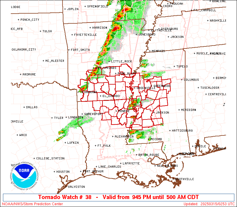
Tornado Watch Number 38
NWS Storm Prediction Center Norman OK
945 PM CDT Fri Mar 14 2025
The NWS Storm Prediction Center has issued a
* Tornado Watch for portions of
Southern Arkansas
Northeast Louisiana
Western Mississippi
* Effective this Friday night and Saturday morning from 945 PM
until 500 AM CDT.
* Primary threats include...
A few tornadoes likely with a couple intense tornadoes possible
Scattered large hail and isolated very large hail events to 2.5
inches in diameter possible
Scattered damaging wind gusts to 70 mph possible
SUMMARY...The moist, unstable, and moderately to strongly sheared
airmass that exists over the region will remain supportive of
thunderstorms capable of all severe hazards, including a strong
(EF2+) tornado, for the next several hours.
The tornado watch area is approximately along and 75 statute miles
east and west of a line from 75 miles southeast of Monroe LA to 35
miles north northwest of Monticello AR. For a complete depiction of
the watch see the associated watch outline update (WOUS64 KWNS
WOU8).
PRECAUTIONARY/PREPAREDNESS ACTIONS...
REMEMBER...A Tornado Watch means conditions are favorable for
tornadoes and severe thunderstorms in and close to the watch
area. Persons in these areas should be on the lookout for
threatening weather conditions and listen for later statements
and possible warnings.
&&
OTHER WATCH INFORMATION...CONTINUE...WW 32...WW 33...WW 34...WW
35...WW 36...WW 37...
AVIATION...Tornadoes and a few severe thunderstorms with hail
surface and aloft to 2.5 inches. Extreme turbulence and surface wind
gusts to 60 knots. A few cumulonimbi with maximum tops to 500. Mean
storm motion vector 24035.
...Mosier
 Note:
The Aviation Watch (SAW) product is an approximation to the watch area.
The actual watch is depicted by the shaded areas.
Note:
The Aviation Watch (SAW) product is an approximation to the watch area.
The actual watch is depicted by the shaded areas.
   SAW8
   WW 38 TORNADO AR LA MS 150245Z - 151000Z
   AXIS..75 STATUTE MILES EAST AND WEST OF LINE..
   75SE MLU/MONROE LA/ - 35NNW LLQ/MONTICELLO AR/
   ..AVIATION COORDS.. 65NM E/W /52WNW MCB - 36SSE LIT/
   HAIL SURFACE AND ALOFT..2.5 INCHES. WIND GUSTS..60 KNOTS.
   MAX TOPS TO 500. MEAN STORM MOTION VECTOR 24035.

   LAT...LON 31749240 34099330 34099067 31748985

   THIS IS AN APPROXIMATION TO THE WATCH AREA.  FOR A
   COMPLETE DEPICTION OF THE WATCH SEE WOUS64 KWNS
   FOR WOU8.
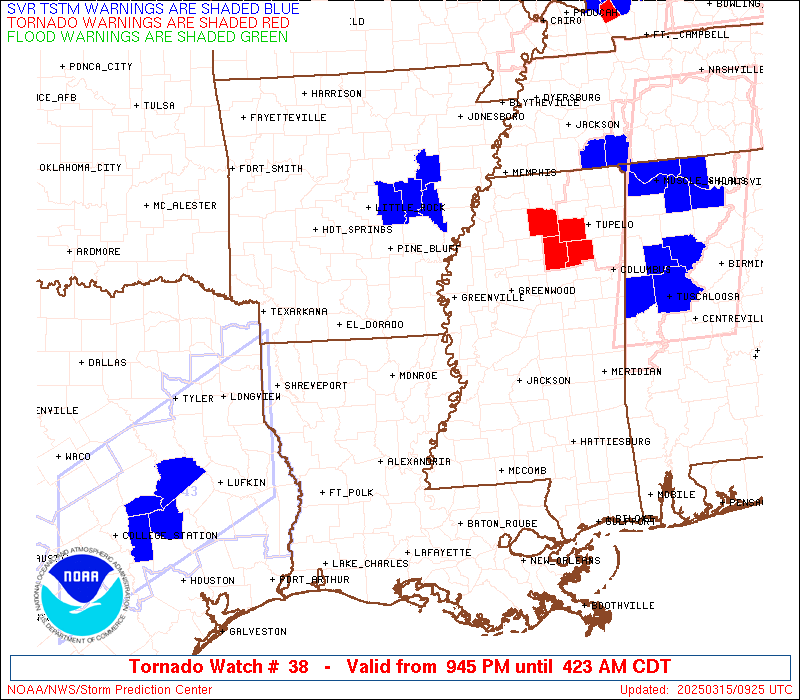
Watch 38 Status Report Messages:
STATUS REPORT #3 ON WW 38

VALID 150750Z - 150840Z

SEVERE WEATHER THREAT CONTINUES RIGHT OF A LINE FROM 35 N PIB TO
35 S GLH TO 10 N ELD TO 25 E DEQ.

..MOORE..03/15/25

ATTN...WFO...LZK...JAN...SHV...

&&

STATUS REPORT FOR WT 38

SEVERE WEATHER THREAT CONTINUES FOR THE FOLLOWING AREAS

ARC001-003-011-013-017-025-039-041-043-069-079-103-150840-

AR
.    ARKANSAS COUNTIES INCLUDED ARE

ARKANSAS	     ASHLEY		 BRADLEY
CALHOUN 	     CHICOT		 CLEVELAND
DALLAS		     DESHA		 DREW
JEFFERSON	     LINCOLN		 OUACHITA
$$


MSC007-011-015-019-025-043-051-053-069-079-083-087-089-097-099-
101-103-105-123-133-151-155-159-163-150840-

MS
.    MISSISSIPPI COUNTIES INCLUDED ARE

ATTALA		     BOLIVAR		 CARROLL
CHOCTAW 	     CLAY		 GRENADA
HOLMES		     HUMPHREYS		 KEMPER
LEAKE		     LEFLORE		 LOWNDES
MADISON 	     MONTGOMERY 	 NESHOBA
NEWTON		     NOXUBEE		 OKTIBBEHA
SCOTT		     SUNFLOWER		 WASHINGTON
WEBSTER 	     WINSTON		 YAZOO
$$


THE WATCH STATUS MESSAGE IS FOR GUIDANCE PURPOSES ONLY.  PLEASE
REFER TO WATCH COUNTY NOTIFICATION STATEMENTS FOR OFFICIAL
INFORMATION ON COUNTIES...INDEPENDENT CITIES AND MARINE ZONES
CLEARED FROM SEVERE THUNDERSTORM AND TORNADO WATCHES.
$$

STATUS REPORT #2 ON WW 38

VALID 150625Z - 150740Z

THE SEVERE WEATHER THREAT CONTINUES ACROSS THE ENTIRE WATCH AREA.

..MOORE..03/15/25

ATTN...WFO...LZK...JAN...SHV...

&&

STATUS REPORT FOR WT 38

SEVERE WEATHER THREAT CONTINUES FOR THE FOLLOWING AREAS

ARC001-003-011-013-017-025-027-039-041-043-053-057-069-073-079-
099-103-139-150740-

AR
.    ARKANSAS COUNTIES INCLUDED ARE

ARKANSAS	     ASHLEY		 BRADLEY
CALHOUN 	     CHICOT		 CLEVELAND
COLUMBIA	     DALLAS		 DESHA
DREW		     GRANT		 HEMPSTEAD
JEFFERSON	     LAFAYETTE		 LINCOLN
NEVADA		     OUACHITA		 UNION
$$


LAC021-027-035-041-049-061-065-067-073-083-107-111-123-150740-

LA
.    LOUISIANA PARISHES INCLUDED ARE

CALDWELL	     CLAIBORNE		 EAST CARROLL
FRANKLIN	     JACKSON		 LINCOLN
MADISON 	     MOREHOUSE		 OUACHITA
RICHLAND	     TENSAS		 UNION
WEST CARROLL
$$


MSC007-011-015-019-021-029-043-049-051-053-055-063-079-083-089-
097-121-125-127-133-149-151-155-163-150740-

MS
.    MISSISSIPPI COUNTIES INCLUDED ARE

ATTALA		     BOLIVAR		 CARROLL
CHOCTAW 	     CLAIBORNE		 COPIAH
GRENADA 	     HINDS		 HOLMES
HUMPHREYS	     ISSAQUENA		 JEFFERSON
LEAKE		     LEFLORE		 MADISON
MONTGOMERY	     RANKIN		 SHARKEY
SIMPSON 	     SUNFLOWER		 WARREN
WASHINGTON	     WEBSTER		 YAZOO
$$


THE WATCH STATUS MESSAGE IS FOR GUIDANCE PURPOSES ONLY.  PLEASE
REFER TO WATCH COUNTY NOTIFICATION STATEMENTS FOR OFFICIAL
INFORMATION ON COUNTIES...INDEPENDENT CITIES AND MARINE ZONES
CLEARED FROM SEVERE THUNDERSTORM AND TORNADO WATCHES.
$$

STATUS REPORT #1 ON WW 38

VALID 150545Z - 150640Z

SEVERE WEATHER THREAT CONTINUES RIGHT OF A LINE FROM 45 S HOT TO
30 SSE HOT.

..GOSS..03/15/25

ATTN...WFO...LZK...JAN...SHV...

&&

STATUS REPORT FOR WT 38

SEVERE WEATHER THREAT CONTINUES FOR THE FOLLOWING AREAS

ARC001-003-011-013-017-025-027-039-041-043-053-057-069-073-079-
099-103-139-150640-

AR
.    ARKANSAS COUNTIES INCLUDED ARE

ARKANSAS	     ASHLEY		 BRADLEY
CALHOUN 	     CHICOT		 CLEVELAND
COLUMBIA	     DALLAS		 DESHA
DREW		     GRANT		 HEMPSTEAD
JEFFERSON	     LAFAYETTE		 LINCOLN
NEVADA		     OUACHITA		 UNION
$$


LAC021-027-035-041-049-061-065-067-073-083-107-111-123-150640-

LA
.    LOUISIANA PARISHES INCLUDED ARE

CALDWELL	     CLAIBORNE		 EAST CARROLL
FRANKLIN	     JACKSON		 LINCOLN
MADISON 	     MOREHOUSE		 OUACHITA
RICHLAND	     TENSAS		 UNION
WEST CARROLL
$$


MSC007-011-015-019-021-029-043-049-051-053-055-063-079-083-089-
097-121-125-127-133-149-151-155-163-150640-

MS
.    MISSISSIPPI COUNTIES INCLUDED ARE

ATTALA		     BOLIVAR		 CARROLL
CHOCTAW 	     CLAIBORNE		 COPIAH
GRENADA 	     HINDS		 HOLMES
HUMPHREYS	     ISSAQUENA		 JEFFERSON
LEAKE		     LEFLORE		 MADISON
MONTGOMERY	     RANKIN		 SHARKEY
SIMPSON 	     SUNFLOWER		 WARREN
WASHINGTON	     WEBSTER		 YAZOO
$$


THE WATCH STATUS MESSAGE IS FOR GUIDANCE PURPOSES ONLY.  PLEASE
REFER TO WATCH COUNTY NOTIFICATION STATEMENTS FOR OFFICIAL
INFORMATION ON COUNTIES...INDEPENDENT CITIES AND MARINE ZONES
CLEARED FROM SEVERE THUNDERSTORM AND TORNADO WATCHES.
$$
Note:
Click for Complete Product Text.
Tornadoes
Probability of 2 or more tornadoes
|
High (70%)
|
Probability of 1 or more strong (EF2-EF5) tornadoes
|
Mod (50%)
|
Wind
Probability of 10 or more severe wind events
|
Mod (40%)
|
Probability of 1 or more wind events > 65 knots
|
Low (20%)
|
Hail
Probability of 10 or more severe hail events
|
Mod (40%)
|
Probability of 1 or more hailstones > 2 inches
|
Mod (40%)
|
Combined Severe Hail/Wind
Probability of 6 or more combined severe hail/wind events
|
High (70%)
|
For each watch, probabilities for particular events inside the watch
(listed above in each table) are determined by the issuing forecaster.
The "Low" category contains probability values ranging from less than 2%
to 20% (EF2-EF5 tornadoes), less than 5% to 20% (all other probabilities),
"Moderate" from 30% to 60%, and "High" from 70% to greater than 95%.
High values are bolded and lighter in color to provide awareness of
an increased threat for a particular event.


 @NWSSPC