 Note:
The expiration time in the watch graphic is amended if the watch is
replaced, cancelled or extended.
Note:
Note:
The expiration time in the watch graphic is amended if the watch is
replaced, cancelled or extended.
Note: Click for
Watch Status Reports.
SEL1
URGENT - IMMEDIATE BROADCAST REQUESTED
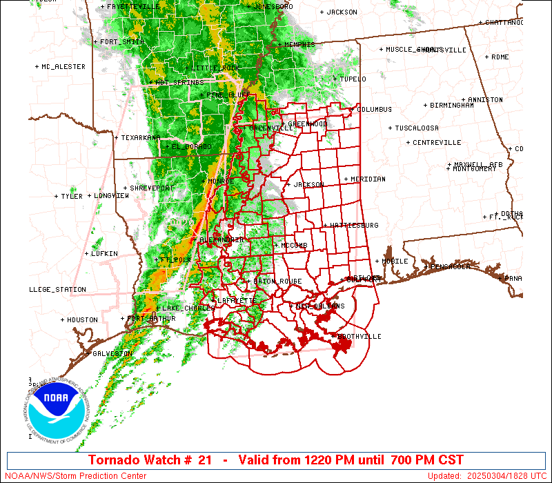
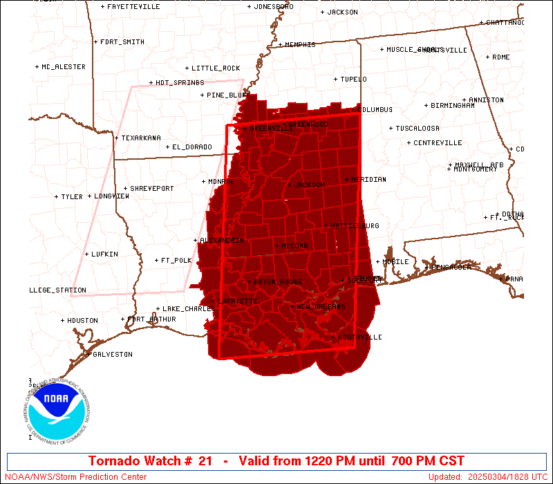
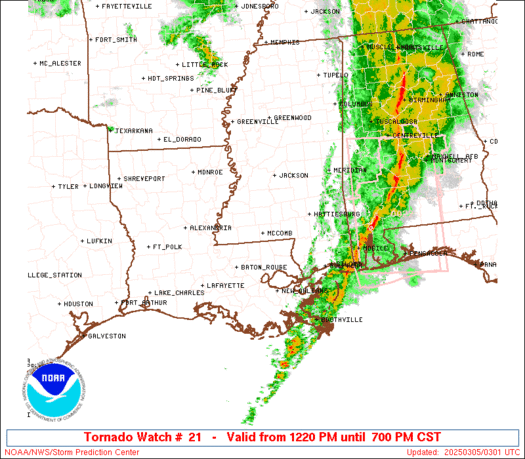
Tornado Watch Number 21
NWS Storm Prediction Center Norman OK
1220 PM CST Tue Mar 4 2025
The NWS Storm Prediction Center has issued a
* Tornado Watch for portions of
Eastern and Southeastern Louisiana
Central and Southern Mississippi
Coastal Waters
* Effective this Tuesday afternoon and evening from 1220 PM until
700 PM CST.
* Primary threats include...
A few tornadoes likely with a couple intense tornadoes possible
Scattered damaging winds and isolated significant gusts to 80
mph likely
Isolated large hail events to 1 inch in diameter possible
SUMMARY...A line of strong to severe thunderstorms continues to push
eastward towards eastern/southern LA along a progressive cold front.
The environment ahead of this front across eastern/southern LA and
into much of central and southern MS will become increasingly
favorable for continued severe thunderstorms over the next several
hours. Tornadoes are the primary severe hazard, with a few strong
(i.e. EF2+) tornadoes possible. Strong to potentially significant
(i.e. over 74 mph) wind gusts are possible within this line as well.
The tornado watch area is approximately along and 90 statute miles
east and west of a line from 15 miles east northeast of Greenwood MS
to 35 miles south southeast of Houma LA. For a complete depiction of
the watch see the associated watch outline update (WOUS64 KWNS
WOU1).
PRECAUTIONARY/PREPAREDNESS ACTIONS...
REMEMBER...A Tornado Watch means conditions are favorable for
tornadoes and severe thunderstorms in and close to the watch
area. Persons in these areas should be on the lookout for
threatening weather conditions and listen for later statements
and possible warnings.
&&
OTHER WATCH INFORMATION...CONTINUE...WW 20...
AVIATION...Tornadoes and a few severe thunderstorms with hail
surface and aloft to 1 inch. Extreme turbulence and surface wind
gusts to 70 knots. A few cumulonimbi with maximum tops to 500. Mean
storm motion vector 24035.
...Mosier
   SEL1

   URGENT - IMMEDIATE BROADCAST REQUESTED
   Tornado Watch Number 21
   NWS Storm Prediction Center Norman OK
   1220 PM CST Tue Mar 4 2025

   The NWS Storm Prediction Center has issued a

   * Tornado Watch for portions of
     Eastern and Southeastern Louisiana
     Central and Southern Mississippi
     Coastal Waters

   * Effective this Tuesday afternoon and evening from 1220 PM until
     700 PM CST.

   * Primary threats include...
     A few tornadoes likely with a couple intense tornadoes possible
     Scattered damaging winds and isolated significant gusts to 80
       mph likely
     Isolated large hail events to 1 inch in diameter possible

   SUMMARY...A line of strong to severe thunderstorms continues to push
   eastward towards eastern/southern LA along a progressive cold front.
   The environment ahead of this front across eastern/southern LA and
   into much of central and southern MS will become increasingly
   favorable for continued severe thunderstorms over the next several
   hours. Tornadoes are the primary severe hazard, with a few strong
   (i.e. EF2+) tornadoes possible. Strong to potentially significant
   (i.e. over 74 mph) wind gusts are possible within this line as well.

   The tornado watch area is approximately along and 90 statute miles
   east and west of a line from 15 miles east northeast of Greenwood MS
   to 35 miles south southeast of Houma LA. For a complete depiction of
   the watch see the associated watch outline update (WOUS64 KWNS
   WOU1).

   PRECAUTIONARY/PREPAREDNESS ACTIONS...

   REMEMBER...A Tornado Watch means conditions are favorable for
   tornadoes and severe thunderstorms in and close to the watch
   area. Persons in these areas should be on the lookout for
   threatening weather conditions and listen for later statements
   and possible warnings.

   &&

   OTHER WATCH INFORMATION...CONTINUE...WW 20...

   AVIATION...Tornadoes and a few severe thunderstorms with hail
   surface and aloft to 1 inch. Extreme turbulence and surface wind
   gusts to 70 knots. A few cumulonimbi with maximum tops to 500. Mean
   storm motion vector 24035.

   ...Mosier
 Note:
The Aviation Watch (SAW) product is an approximation to the watch area.
The actual watch is depicted by the shaded areas.
Note:
The Aviation Watch (SAW) product is an approximation to the watch area.
The actual watch is depicted by the shaded areas.
   SAW1
   WW 21 TORNADO LA MS CW 041820Z - 050100Z
   AXIS..90 STATUTE MILES EAST AND WEST OF LINE..
   15ENE GWO/GREENWOOD MS/ - 35SSE HUM/HOUMA LA/
   ..AVIATION COORDS.. 80NM E/W /23ENE SQS - 19WSW LEV/
   HAIL SURFACE AND ALOFT..1 INCH. WIND GUSTS..70 KNOTS.
   MAX TOPS TO 500. MEAN STORM MOTION VECTOR 24035.

   LAT...LON 33578828 29098896 29099194 33579140

   THIS IS AN APPROXIMATION TO THE WATCH AREA.  FOR A
   COMPLETE DEPICTION OF THE WATCH SEE WOUS64 KWNS
   FOR WOU1.
Watch 21 Status Report Messages:
STATUS REPORT #3 ON WW 21
VALID 050025Z - 050140Z
SEVERE WEATHER THREAT CONTINUES RIGHT OF A LINE FROM 45 SW HUM TO
30 SSW MEI TO 5 SW CBM.
..SPC..03/05/25
ATTN...WFO...LIX...LCH...JAN...MOB...
&&
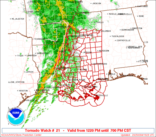
STATUS REPORT FOR WT 21
SEVERE WEATHER THREAT CONTINUES FOR THE FOLLOWING AREAS
LAC051-057-071-075-087-089-103-109-117-050140-
LA
. LOUISIANA PARISHES INCLUDED ARE
JEFFERSON LAFOURCHE ORLEANS
PLAQUEMINES ST. BERNARD ST. CHARLES
ST. TAMMANY TERREBONNE WASHINGTON
$$
MSC023-035-039-041-045-047-059-067-069-073-075-109-111-131-153-
050140-
MS
. MISSISSIPPI COUNTIES INCLUDED ARE
CLARKE FORREST GEORGE
GREENE HANCOCK HARRISON
JACKSON JONES KEMPER
LAMAR LAUDERDALE PEARL RIVER
PERRY STONE WAYNE
$$
GMZ530-532-534-536-538-550-552-555-557-050140-
CW
. ADJACENT COASTAL WATERS INCLUDED ARE
LAKE PONTCHARTRAIN AND LAKE MAUREPAS
MISSISSIPPI SOUND
LAKE BORGNE
CHANDELEUR SOUND
BRETON SOUND
COASTAL WATERS FROM PORT FOURCHON LA TO LOWER ATCHAFALAYA RIVER
LA OUT 20 NM
COASTAL WATERS FROM THE SOUTHWEST PASS OF THE MISSISSIPPI RIVER
TO PORT FOURCHON LOUISIANA OUT 20 NM
COASTAL WATERS FROM BOOTHVILLE LA TO SOUTHWEST PASS OF THE
MISSISSIPPI RIVER OUT 20 NM
COASTAL WATERS FROM PASCAGOULA MISSISSIPPI TO STAKE ISLAND OUT 20
NM
$$
THE WATCH STATUS MESSAGE IS FOR GUIDANCE PURPOSES ONLY. PLEASE
REFER TO WATCH COUNTY NOTIFICATION STATEMENTS FOR OFFICIAL
INFORMATION ON COUNTIES...INDEPENDENT CITIES AND MARINE ZONES
CLEARED FROM SEVERE THUNDERSTORM AND TORNADO WATCHES.
$$
STATUS REPORT #2 ON WW 21
VALID 042000Z - 042140Z
SEVERE WEATHER THREAT CONTINUES RIGHT OF A LINE FROM 30 WNW HEZ
TO 50 S GLH TO 25 NE GLH.
..SUPINIE..03/04/25
ATTN...WFO...LIX...LCH...JAN...MOB...
&&
STATUS REPORT FOR WT 21
SEVERE WEATHER THREAT CONTINUES FOR THE FOLLOWING AREAS
LAC005-007-009-025-029-033-037-045-047-051-055-057-063-065-071-
075-077-087-089-091-093-095-097-099-101-103-105-107-109-117-121-
125-042140-
LA
. LOUISIANA PARISHES INCLUDED ARE
ASCENSION ASSUMPTION AVOYELLES
CATAHOULA CONCORDIA EAST BATON ROUGE
EAST FELICIANA IBERIA IBERVILLE
JEFFERSON LAFAYETTE LAFOURCHE
LIVINGSTON MADISON ORLEANS
PLAQUEMINES POINTE COUPEE ST. BERNARD
ST. CHARLES ST. HELENA ST. JAMES
ST. JOHN THE BAPTIST ST. LANDRY ST. MARTIN
ST. MARY ST. TAMMANY TANGIPAHOA
TENSAS TERREBONNE WASHINGTON
WEST BATON ROUGE WEST FELICIANA
$$
MSC001-005-007-015-019-021-023-025-029-031-035-037-039-041-043-
045-047-049-051-053-055-059-061-063-065-067-069-073-075-077-079-
083-085-087-089-091-097-099-101-103-105-109-111-113-121-123-125-
127-129-131-133-147-149-153-155-157-159-163-042140-
MS
. MISSISSIPPI COUNTIES INCLUDED ARE
ADAMS AMITE ATTALA
CARROLL CHOCTAW CLAIBORNE
CLARKE CLAY COPIAH
COVINGTON FORREST FRANKLIN
GEORGE GREENE GRENADA
HANCOCK HARRISON HINDS
HOLMES HUMPHREYS ISSAQUENA
JACKSON JASPER JEFFERSON
JEFFERSON DAVIS JONES KEMPER
LAMAR LAUDERDALE LAWRENCE
LEAKE LEFLORE LINCOLN
LOWNDES MADISON MARION
MONTGOMERY NESHOBA NEWTON
NOXUBEE OKTIBBEHA PEARL RIVER
PERRY PIKE RANKIN
SCOTT SHARKEY SIMPSON
SMITH STONE SUNFLOWER
WALTHALL WARREN WAYNE
WEBSTER WILKINSON WINSTON
YAZOO
$$
GMZ435-436-455-530-532-534-536-538-550-552-555-557-042140-
CW
. ADJACENT COASTAL WATERS INCLUDED ARE
VERMILION AND WEST COTE BLANCHE BAYS
ATCHAFALAYA AND EAST COTE BLANCHE BAYS
COASTAL WATERS FROM LOWER ATCHAFALAYA RIVER TO INTRACOASTAL CITY
LA OUT 20 NM
LAKE PONTCHARTRAIN AND LAKE MAUREPAS
MISSISSIPPI SOUND
LAKE BORGNE
CHANDELEUR SOUND
BRETON SOUND
COASTAL WATERS FROM PORT FOURCHON LA TO LOWER ATCHAFALAYA RIVER
LA OUT 20 NM
COASTAL WATERS FROM THE SOUTHWEST PASS OF THE MISSISSIPPI RIVER
TO PORT FOURCHON LOUISIANA OUT 20 NM
COASTAL WATERS FROM BOOTHVILLE LA TO SOUTHWEST PASS OF THE
MISSISSIPPI RIVER OUT 20 NM
COASTAL WATERS FROM PASCAGOULA MISSISSIPPI TO STAKE ISLAND OUT 20
NM
$$
THE WATCH STATUS MESSAGE IS FOR GUIDANCE PURPOSES ONLY. PLEASE
REFER TO WATCH COUNTY NOTIFICATION STATEMENTS FOR OFFICIAL
INFORMATION ON COUNTIES...INDEPENDENT CITIES AND MARINE ZONES
CLEARED FROM SEVERE THUNDERSTORM AND TORNADO WATCHES.
$$
STATUS REPORT #1 ON WW 21
VALID 041920Z - 042040Z
THE SEVERE WEATHER THREAT CONTINUES ACROSS THE ENTIRE WATCH AREA.
..SUPINIE..03/04/25
ATTN...WFO...LIX...LCH...JAN...MOB...
&&
STATUS REPORT FOR WT 21
SEVERE WEATHER THREAT CONTINUES FOR THE FOLLOWING AREAS
LAC005-007-009-025-029-033-035-037-041-045-047-051-055-057-063-
065-071-075-077-087-089-091-093-095-097-099-101-103-105-107-109-
117-121-125-042040-
LA
. LOUISIANA PARISHES INCLUDED ARE
ASCENSION ASSUMPTION AVOYELLES
CATAHOULA CONCORDIA EAST BATON ROUGE
EAST CARROLL EAST FELICIANA FRANKLIN
IBERIA IBERVILLE JEFFERSON
LAFAYETTE LAFOURCHE LIVINGSTON
MADISON ORLEANS PLAQUEMINES
POINTE COUPEE ST. BERNARD ST. CHARLES
ST. HELENA ST. JAMES ST. JOHN THE BAPTIST
ST. LANDRY ST. MARTIN ST. MARY
ST. TAMMANY TANGIPAHOA TENSAS
TERREBONNE WASHINGTON WEST BATON ROUGE
WEST FELICIANA
$$
MSC001-005-007-011-015-019-021-023-025-029-031-035-037-039-041-
043-045-047-049-051-053-055-059-061-063-065-067-069-073-075-077-
079-083-085-087-089-091-097-099-101-103-105-109-111-113-121-123-
125-127-129-131-133-147-149-151-153-155-157-159-163-042040-
MS
. MISSISSIPPI COUNTIES INCLUDED ARE
ADAMS AMITE ATTALA
BOLIVAR CARROLL CHOCTAW
CLAIBORNE CLARKE CLAY
COPIAH COVINGTON FORREST
FRANKLIN GEORGE GREENE
GRENADA HANCOCK HARRISON
HINDS HOLMES HUMPHREYS
ISSAQUENA JACKSON JASPER
JEFFERSON JEFFERSON DAVIS JONES
KEMPER LAMAR LAUDERDALE
LAWRENCE LEAKE LEFLORE
LINCOLN LOWNDES MADISON
MARION MONTGOMERY NESHOBA
NEWTON NOXUBEE OKTIBBEHA
PEARL RIVER PERRY PIKE
RANKIN SCOTT SHARKEY
SIMPSON SMITH STONE
SUNFLOWER WALTHALL WARREN
WASHINGTON WAYNE WEBSTER
WILKINSON WINSTON YAZOO
$$
GMZ435-436-455-530-532-534-536-538-550-552-555-557-042040-
CW
. ADJACENT COASTAL WATERS INCLUDED ARE
VERMILION AND WEST COTE BLANCHE BAYS
ATCHAFALAYA AND EAST COTE BLANCHE BAYS
COASTAL WATERS FROM LOWER ATCHAFALAYA RIVER TO INTRACOASTAL CITY
LA OUT 20 NM
LAKE PONTCHARTRAIN AND LAKE MAUREPAS
MISSISSIPPI SOUND
LAKE BORGNE
CHANDELEUR SOUND
BRETON SOUND
COASTAL WATERS FROM PORT FOURCHON LA TO LOWER ATCHAFALAYA RIVER
LA OUT 20 NM
COASTAL WATERS FROM THE SOUTHWEST PASS OF THE MISSISSIPPI RIVER
TO PORT FOURCHON LOUISIANA OUT 20 NM
COASTAL WATERS FROM BOOTHVILLE LA TO SOUTHWEST PASS OF THE
MISSISSIPPI RIVER OUT 20 NM
COASTAL WATERS FROM PASCAGOULA MISSISSIPPI TO STAKE ISLAND OUT 20
NM
$$
THE WATCH STATUS MESSAGE IS FOR GUIDANCE PURPOSES ONLY. PLEASE
REFER TO WATCH COUNTY NOTIFICATION STATEMENTS FOR OFFICIAL
INFORMATION ON COUNTIES...INDEPENDENT CITIES AND MARINE ZONES
CLEARED FROM SEVERE THUNDERSTORM AND TORNADO WATCHES.
$$
Note:
Click for Complete Product Text.
Tornadoes
Probability of 2 or more tornadoes
|
Mod (60%)
|
Probability of 1 or more strong (EF2-EF5) tornadoes
|
Mod (40%)
|
Wind
Probability of 10 or more severe wind events
|
Mod (60%)
|
Probability of 1 or more wind events > 65 knots
|
Mod (60%)
|
Hail
Probability of 10 or more severe hail events
|
Low (20%)
|
Probability of 1 or more hailstones > 2 inches
|
Low (10%)
|
Combined Severe Hail/Wind
Probability of 6 or more combined severe hail/wind events
|
High (80%)
|
For each watch, probabilities for particular events inside the watch
(listed above in each table) are determined by the issuing forecaster.
The "Low" category contains probability values ranging from less than 2%
to 20% (EF2-EF5 tornadoes), less than 5% to 20% (all other probabilities),
"Moderate" from 30% to 60%, and "High" from 70% to greater than 95%.
High values are bolded and lighter in color to provide awareness of
an increased threat for a particular event.


 @NWSSPC