|
| Mesoscale Discussion 138 |
|
[an error occurred while processing this directive]
|
|
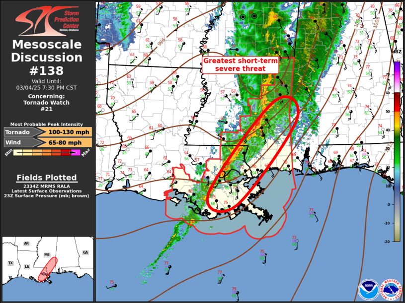
   Mesoscale Discussion 0138
   NWS Storm Prediction Center Norman OK
   0536 PM CST Tue Mar 04 2025

   Areas affected...Lower Mississippi Valley

   Concerning...Tornado Watch 21...

   Valid 042336Z - 050130Z

   The severe weather threat for Tornado Watch 21 continues.

   SUMMARY...Severe threat will spread southeast this evening. Damaging
   winds can be expected, along with some risk for a few tornadoes.

   DISCUSSION...Intense mid-level height falls will spread across the
   mid-Mississippi valley this evening, with lesser, but significant
   forcing extending south across the lower MS Valley ahead of a strong
   short-wave trough. Long-lived, organized squall line is propagating
   southeast ahead of this feature, and currently extends from
   east-central MS into southeast LA. Higher boundary-layer moisture
   has struggled to move appreciably inland with mid 60s surface dew
   points having advanced into Jones County MS, roughly 70 mi north of
   the Coast. This is about the northern extent of modest buoyancy, and
   the greatest instability should hold along/near the Gulf Coast much
   of the evening. Very strong wind profiles continue to favor
   organized convection and damaging winds are expected with this
   linear MCS. Until/unless more discrete cells form ahead of the line,
   any tornado risk should be with embedded supercells.

   ..Darrow.. 03/04/2025

   ...Please see www.spc.noaa.gov for graphic product...

   ATTN...WFO...MOB...JAN...LIX...

   LAT...LON   29749089 32148894 31678825 29459006 29749089
|
|
Top/All Mesoscale Discussions/Forecast Products/Home
|
|


 @NWSSPC