Note:
The expiration time in the watch graphic is amended if the watch is
replaced, cancelled or extended.
Note:
Note:
The expiration time in the watch graphic is amended if the watch is
replaced, cancelled or extended.
Note: Click for
Watch Status Reports.
SEL0
URGENT - IMMEDIATE BROADCAST REQUESTED
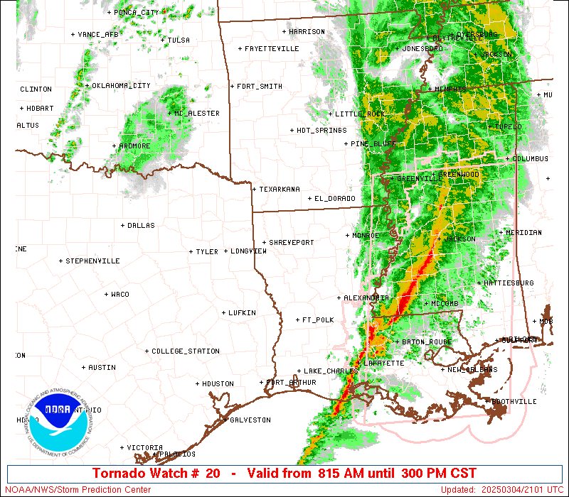
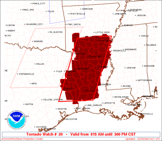
Tornado Watch Number 20
NWS Storm Prediction Center Norman OK
815 AM CST Tue Mar 4 2025
The NWS Storm Prediction Center has issued a
* Tornado Watch for portions of
Southern Arkansas
Western and Northern Louisiana
East Texas
* Effective this Tuesday morning and afternoon from 815 AM until
300 PM CST.
* Primary threats include...
A few tornadoes and a couple intense tornadoes possible
Scattered damaging winds and isolated significant gusts to 75
mph likely
Isolated large hail events to 1.5 inches in diameter possible
SUMMARY...A broken squall line will continue east into the Watch
area this morning. A destabilizing airmass near and immediately
ahead of this strong to severe thunderstorm activity will aid in a
severe risk continuing eastward through the early afternoon.
Scattered severe gusts and a risk for tornadoes will be the primary
hazards with the stronger storms.
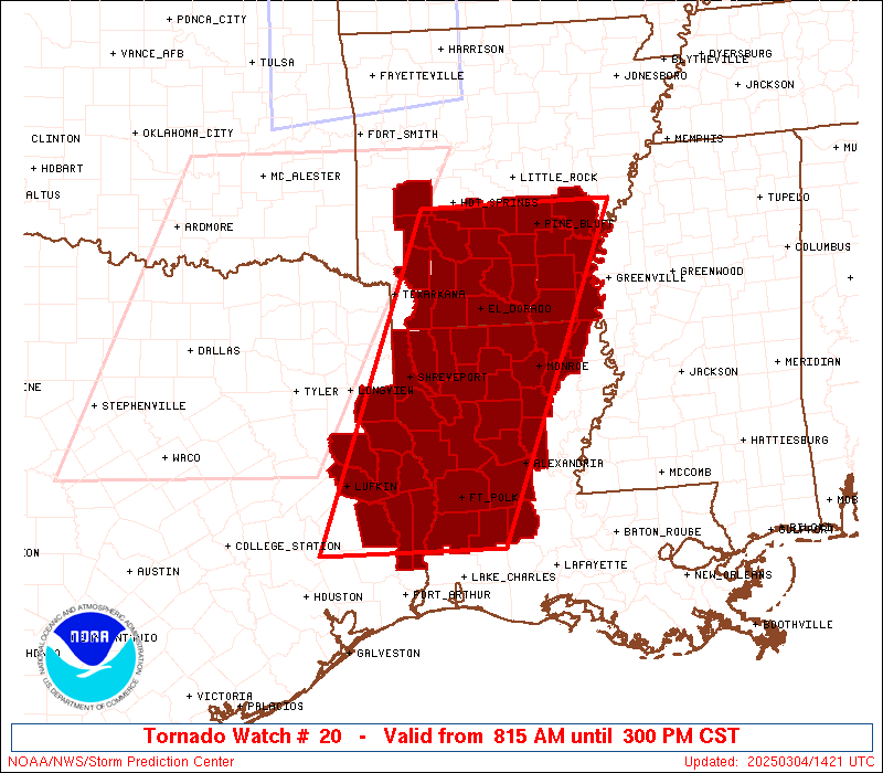
The tornado watch area is approximately along and 75 statute miles
east and west of a line from 25 miles northwest of Pine Bluff AR to
60 miles southwest of Fort Polk LA. For a complete depiction of the
watch see the associated watch outline update (WOUS64 KWNS WOU0).
PRECAUTIONARY/PREPAREDNESS ACTIONS...
REMEMBER...A Tornado Watch means conditions are favorable for
tornadoes and severe thunderstorms in and close to the watch
area. Persons in these areas should be on the lookout for
threatening weather conditions and listen for later statements
and possible warnings.
&&
OTHER WATCH INFORMATION...CONTINUE...WW 18...WW 19...
AVIATION...Tornadoes and a few severe thunderstorms with hail
surface and aloft to 1.5 inches. Extreme turbulence and surface wind
gusts to 65 knots. A few cumulonimbi with maximum tops to 450. Mean
storm motion vector 25045.
...Smith
 Note:
The Aviation Watch (SAW) product is an approximation to the watch area.
The actual watch is depicted by the shaded areas.
Note:
The Aviation Watch (SAW) product is an approximation to the watch area.
The actual watch is depicted by the shaded areas.
   SAW0
   WW 20 TORNADO AR LA TX 041415Z - 042100Z
   AXIS..75 STATUTE MILES EAST AND WEST OF LINE..
   25NW PBF/PINE BLUFF AR/ - 60SW POE/FORT POLK LA/
   ..AVIATION COORDS.. 65NM E/W /16S LIT - 44WNW LCH/
   HAIL SURFACE AND ALOFT..1.5 INCHES. WIND GUSTS..65 KNOTS.
   MAX TOPS TO 450. MEAN STORM MOTION VECTOR 25045.

   LAT...LON 34419092 30439263 30439515 34419356

   THIS IS AN APPROXIMATION TO THE WATCH AREA.  FOR A
   COMPLETE DEPICTION OF THE WATCH SEE WOUS64 KWNS
   FOR WOU0.
Watch 20 Status Report Messages:
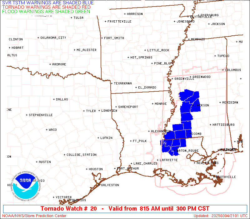
STATUS REPORT #6 ON WW 20
VALID 042000Z - 042100Z
SEVERE WEATHER THREAT CONTINUES RIGHT OF A LINE FROM 30 NE LCH TO
20 S ESF.
WW 20 WILL BE ALLOWED TO EXPIRE AT 042100Z.
..SUPINIE..03/04/25
ATTN...WFO...LZK...JAN...SHV...LCH...
&&
STATUS REPORT FOR WT 20
SEVERE WEATHER THREAT CONTINUES FOR THE FOLLOWING AREAS
LAC001-023-039-053-113-042100-
LA
. LOUISIANA PARISHES INCLUDED ARE
ACADIA CAMERON EVANGELINE
JEFFERSON DAVIS VERMILION
$$
THE WATCH STATUS MESSAGE IS FOR GUIDANCE PURPOSES ONLY. PLEASE
REFER TO WATCH COUNTY NOTIFICATION STATEMENTS FOR OFFICIAL
INFORMATION ON COUNTIES...INDEPENDENT CITIES AND MARINE ZONES
CLEARED FROM SEVERE THUNDERSTORM AND TORNADO WATCHES.
$$
STATUS REPORT #5 ON WW 20
VALID 041915Z - 042040Z
SEVERE WEATHER THREAT CONTINUES RIGHT OF A LINE FROM 20 N LCH TO
40 SSE MLU.
..SUPINIE..03/04/25
ATTN...WFO...LZK...JAN...SHV...LCH...
&&
STATUS REPORT FOR WT 20
SEVERE WEATHER THREAT CONTINUES FOR THE FOLLOWING AREAS
LAC001-003-019-023-039-053-059-079-113-042040-
LA
. LOUISIANA PARISHES INCLUDED ARE
ACADIA ALLEN CALCASIEU
CAMERON EVANGELINE JEFFERSON DAVIS
LA SALLE RAPIDES VERMILION
$$
THE WATCH STATUS MESSAGE IS FOR GUIDANCE PURPOSES ONLY. PLEASE
REFER TO WATCH COUNTY NOTIFICATION STATEMENTS FOR OFFICIAL
INFORMATION ON COUNTIES...INDEPENDENT CITIES AND MARINE ZONES
CLEARED FROM SEVERE THUNDERSTORM AND TORNADO WATCHES.
$$
STATUS REPORT #4 ON WW 20
VALID 041825Z - 041940Z
SEVERE WEATHER THREAT CONTINUES RIGHT OF A LINE FROM 35 NNE BPT
TO 25 WNW ESF TO 10 ENE LLQ TO 35 E LIT.
..SUPINIE..03/04/25
ATTN...WFO...LZK...JAN...SHV...LCH...
&&
STATUS REPORT FOR WT 20
SEVERE WEATHER THREAT CONTINUES FOR THE FOLLOWING AREAS
ARC001-003-017-041-041940-
AR
. ARKANSAS COUNTIES INCLUDED ARE
ARKANSAS ASHLEY CHICOT
DESHA
$$
LAC001-003-011-019-021-023-039-053-059-067-073-079-083-113-123-
041940-
LA
. LOUISIANA PARISHES INCLUDED ARE
ACADIA ALLEN BEAUREGARD
CALCASIEU CALDWELL CAMERON
EVANGELINE JEFFERSON DAVIS LA SALLE
MOREHOUSE OUACHITA RAPIDES
RICHLAND VERMILION WEST CARROLL
$$
TXC245-361-041940-
TX
. TEXAS COUNTIES INCLUDED ARE
JEFFERSON ORANGE
$$
THE WATCH STATUS MESSAGE IS FOR GUIDANCE PURPOSES ONLY. PLEASE
REFER TO WATCH COUNTY NOTIFICATION STATEMENTS FOR OFFICIAL
INFORMATION ON COUNTIES...INDEPENDENT CITIES AND MARINE ZONES
CLEARED FROM SEVERE THUNDERSTORM AND TORNADO WATCHES.
$$
STATUS REPORT #3 ON WW 20
VALID 041725Z - 041840Z
SEVERE WEATHER THREAT CONTINUES RIGHT OF A LINE FROM 35 NNW BPT
TO 20 WNW POE TO 20 E ELD TO 15 SSW LIT.
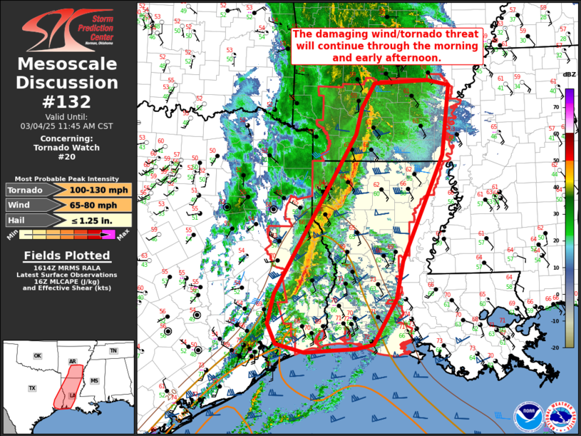
FOR ADDITIONAL INFORMATION SEE MESOSCALE DISCUSSION 132
..SUPINIE..03/04/25
ATTN...WFO...LZK...JAN...SHV...LCH...
&&
STATUS REPORT FOR WT 20
SEVERE WEATHER THREAT CONTINUES FOR THE FOLLOWING AREAS
ARC001-003-011-017-025-041-043-069-079-139-041840-
AR
. ARKANSAS COUNTIES INCLUDED ARE
ARKANSAS ASHLEY BRADLEY
CHICOT CLEVELAND DESHA
DREW JEFFERSON LINCOLN
UNION
$$
LAC001-003-011-019-021-023-039-043-049-053-059-061-067-069-073-
079-083-111-113-115-123-127-041840-
LA
. LOUISIANA PARISHES INCLUDED ARE
ACADIA ALLEN BEAUREGARD
CALCASIEU CALDWELL CAMERON
EVANGELINE GRANT JACKSON
JEFFERSON DAVIS LA SALLE LINCOLN
MOREHOUSE NATCHITOCHES OUACHITA
RAPIDES RICHLAND UNION
VERMILION VERNON WEST CARROLL
WINN
$$
TXC245-351-361-041840-
TX
. TEXAS COUNTIES INCLUDED ARE
JEFFERSON NEWTON ORANGE
$$
THE WATCH STATUS MESSAGE IS FOR GUIDANCE PURPOSES ONLY. PLEASE
REFER TO WATCH COUNTY NOTIFICATION STATEMENTS FOR OFFICIAL
INFORMATION ON COUNTIES...INDEPENDENT CITIES AND MARINE ZONES
CLEARED FROM SEVERE THUNDERSTORM AND TORNADO WATCHES.
$$
STATUS REPORT #2 ON WW 20
VALID 041650Z - 041740Z
SEVERE WEATHER THREAT CONTINUES RIGHT OF A LINE FROM 35 NW BPT TO
45 ESE LFK TO 45 WSW IER TO 30 ESE SHV TO 30 SSW ELD TO 5 NE ELD
TO 35 SE HOT TO 25 NE HOT.
..BENTLEY..03/04/25
ATTN...WFO...LZK...JAN...SHV...LCH...
&&
STATUS REPORT FOR WT 20
SEVERE WEATHER THREAT CONTINUES FOR THE FOLLOWING AREAS
ARC001-003-011-013-017-025-039-041-043-053-069-079-139-041740-
AR
. ARKANSAS COUNTIES INCLUDED ARE
ARKANSAS ASHLEY BRADLEY
CALHOUN CHICOT CLEVELAND
DALLAS DESHA DREW
GRANT JEFFERSON LINCOLN
UNION
$$
LAC001-003-011-013-019-021-023-027-031-039-043-049-053-059-061-
067-069-073-079-081-083-085-111-113-115-123-127-041740-
LA
. LOUISIANA PARISHES INCLUDED ARE
ACADIA ALLEN BEAUREGARD
BIENVILLE CALCASIEU CALDWELL
CAMERON CLAIBORNE DE SOTO
EVANGELINE GRANT JACKSON
JEFFERSON DAVIS LA SALLE LINCOLN
MOREHOUSE NATCHITOCHES OUACHITA
RAPIDES RED RIVER RICHLAND
SABINE UNION VERMILION
VERNON WEST CARROLL WINN
$$
TXC199-241-245-351-361-403-041740-
TX
. TEXAS COUNTIES INCLUDED ARE
HARDIN JASPER JEFFERSON
NEWTON ORANGE SABINE
$$
THE WATCH STATUS MESSAGE IS FOR GUIDANCE PURPOSES ONLY. PLEASE
REFER TO WATCH COUNTY NOTIFICATION STATEMENTS FOR OFFICIAL
INFORMATION ON COUNTIES...INDEPENDENT CITIES AND MARINE ZONES
CLEARED FROM SEVERE THUNDERSTORM AND TORNADO WATCHES.
$$
STATUS REPORT #1 ON WW 20
VALID 041535Z - 041640Z
SEVERE WEATHER THREAT CONTINUES RIGHT OF A LINE FROM 25 SSE UTS
TO 30 SE GGG TO 35 SSE TXK TO 45 SW HOT TO 35 WNW HOT.
..BENTLEY..03/04/25
ATTN...WFO...LZK...JAN...SHV...LCH...
&&
STATUS REPORT FOR WT 20
SEVERE WEATHER THREAT CONTINUES FOR THE FOLLOWING AREAS
ARC001-003-011-013-017-019-025-027-039-041-043-053-057-059-069-
073-079-097-099-103-109-139-041640-
AR
. ARKANSAS COUNTIES INCLUDED ARE
ARKANSAS ASHLEY BRADLEY
CALHOUN CHICOT CLARK
CLEVELAND COLUMBIA DALLAS
DESHA DREW GRANT
HEMPSTEAD HOT SPRING JEFFERSON
LAFAYETTE LINCOLN MONTGOMERY
NEVADA OUACHITA PIKE
UNION
$$
LAC003-011-013-015-017-021-027-031-039-043-049-059-061-067-069-
073-079-081-083-085-111-115-119-123-127-041640-
LA
. LOUISIANA PARISHES INCLUDED ARE
ALLEN BEAUREGARD BIENVILLE
BOSSIER CADDO CALDWELL
CLAIBORNE DE SOTO EVANGELINE
GRANT JACKSON LA SALLE
LINCOLN MOREHOUSE NATCHITOCHES
OUACHITA RAPIDES RED RIVER
RICHLAND SABINE UNION
VERNON WEBSTER WEST CARROLL
WINN
$$
TXC005-241-347-351-365-403-405-419-457-041640-
TX
. TEXAS COUNTIES INCLUDED ARE
ANGELINA JASPER NACOGDOCHES
NEWTON PANOLA SABINE
SAN AUGUSTINE SHELBY TYLER
$$
THE WATCH STATUS MESSAGE IS FOR GUIDANCE PURPOSES ONLY. PLEASE
REFER TO WATCH COUNTY NOTIFICATION STATEMENTS FOR OFFICIAL
INFORMATION ON COUNTIES...INDEPENDENT CITIES AND MARINE ZONES
CLEARED FROM SEVERE THUNDERSTORM AND TORNADO WATCHES.
$$
Note:
Click for Complete Product Text.
Tornadoes
Probability of 2 or more tornadoes
|
Mod (50%)
|
Probability of 1 or more strong (EF2-EF5) tornadoes
|
Mod (30%)
|
Wind
Probability of 10 or more severe wind events
|
High (70%)
|
Probability of 1 or more wind events > 65 knots
|
Mod (60%)
|
Hail
Probability of 10 or more severe hail events
|
Low (20%)
|
Probability of 1 or more hailstones > 2 inches
|
Low (20%)
|
Combined Severe Hail/Wind
Probability of 6 or more combined severe hail/wind events
|
High (90%)
|
For each watch, probabilities for particular events inside the watch
(listed above in each table) are determined by the issuing forecaster.
The "Low" category contains probability values ranging from less than 2%
to 20% (EF2-EF5 tornadoes), less than 5% to 20% (all other probabilities),
"Moderate" from 30% to 60%, and "High" from 70% to greater than 95%.
High values are bolded and lighter in color to provide awareness of
an increased threat for a particular event.


 @NWSSPC