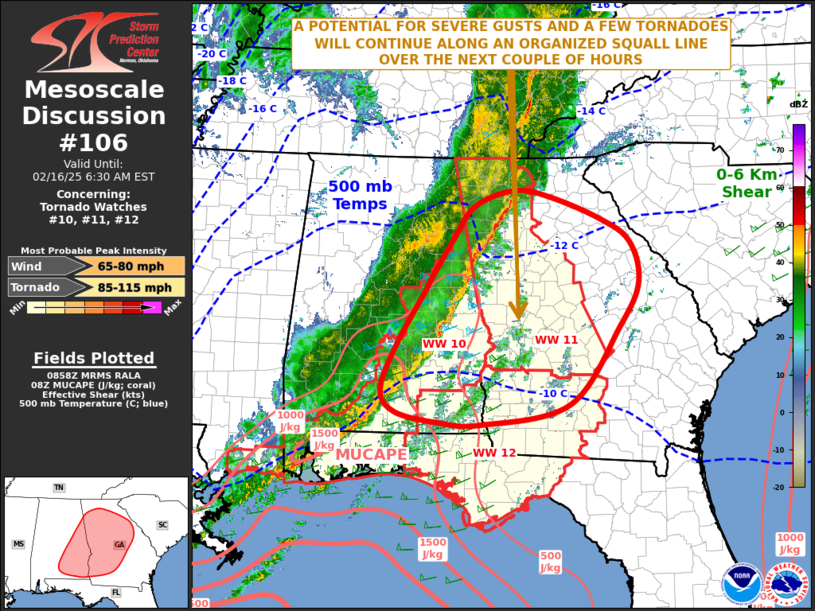
   Mesoscale Discussion 0106
   NWS Storm Prediction Center Norman OK
   0301 AM CST Sun Feb 16 2025

   Areas affected...Southeast Alabama...Georgia

   Concerning...Tornado Watch 10...11...12...

   Valid 160901Z - 161130Z

   The severe weather threat for Tornado Watch 10, 11, 12 continues.

   SUMMARY...A potential for severe gusts and a few tornadoes will
   likely continue for a few more hours over parts of southeast Alabama
   and western to central Georgia.

   DISCUSSION...The latest water vapor imagery shows a plume of
   mid-level moisture over the central Gulf Coast states, which is
   associated with a shortwave trough and ongoing squall line. The line
   is located from Mobile, Alabama north-northeastward to near Atlanta,
   Georgia and is just ahead of a fast-moving cold front. Ahead of the
   line, surface dewpoints are in mostly in the 60s F, with mid to
   upper 50s F over north-central Georgia. The RAP shows weak
   instability ahead of the squall line, with MUCAPE generally near or
   below 500 J/kg across much of southeast Alabama and western Georgia.
   The WSR-88D VWP ahead of the line at MXX near Auburn, Alabama shows
   very strong speed shear in the boundary layer with winds increasing
   to around 70 knots at one kilometer above ground. For this reason,
   it will not be hard for the more organized parts of the line to
   produce severe gusts. In addition, storm-relative helicity is very
   strong, which should enable a tornado threat to continue. However,
   the tornado threat will remain isolated, mainly due to weak
   instability and the lack of discrete cells ahead of the squall line.
   As the line moves eastward, a slow downtrend in the overall severe
   threat is expected.

   ..Broyles.. 02/16/2025

   ...Please see www.spc.noaa.gov for graphic product...

   ATTN...WFO...CAE...FFC...TAE...BMX...MOB...

   LAT...LON   32528275 33178241 33768257 34098307 34428393 34528454
               34288523 33808560 33268596 33018611 32288655 31638683
               31308658 31148585 31128512 31408361 32528275
|


 @NWSSPC