 Note:
The expiration time in the watch graphic is amended if the watch is
replaced, cancelled or extended.
Note:
Note:
The expiration time in the watch graphic is amended if the watch is
replaced, cancelled or extended.
Note: Click for
Watch Status Reports.
SEL8
URGENT - IMMEDIATE BROADCAST REQUESTED
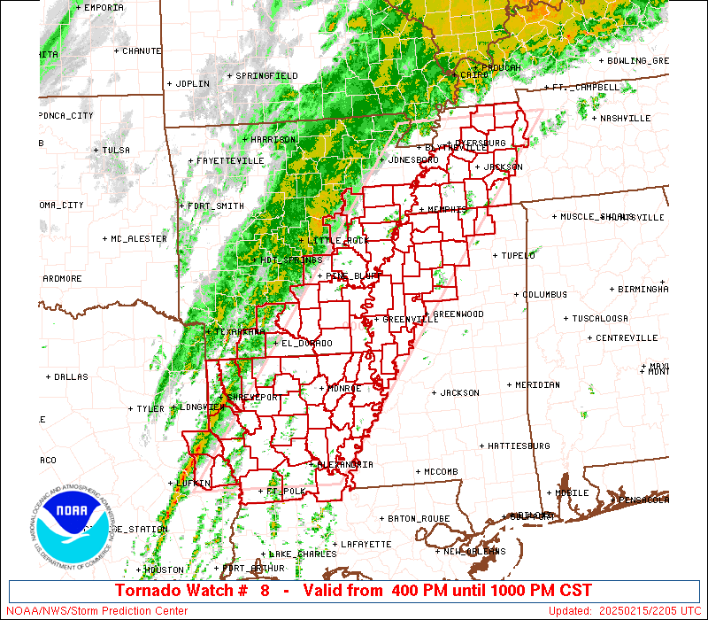
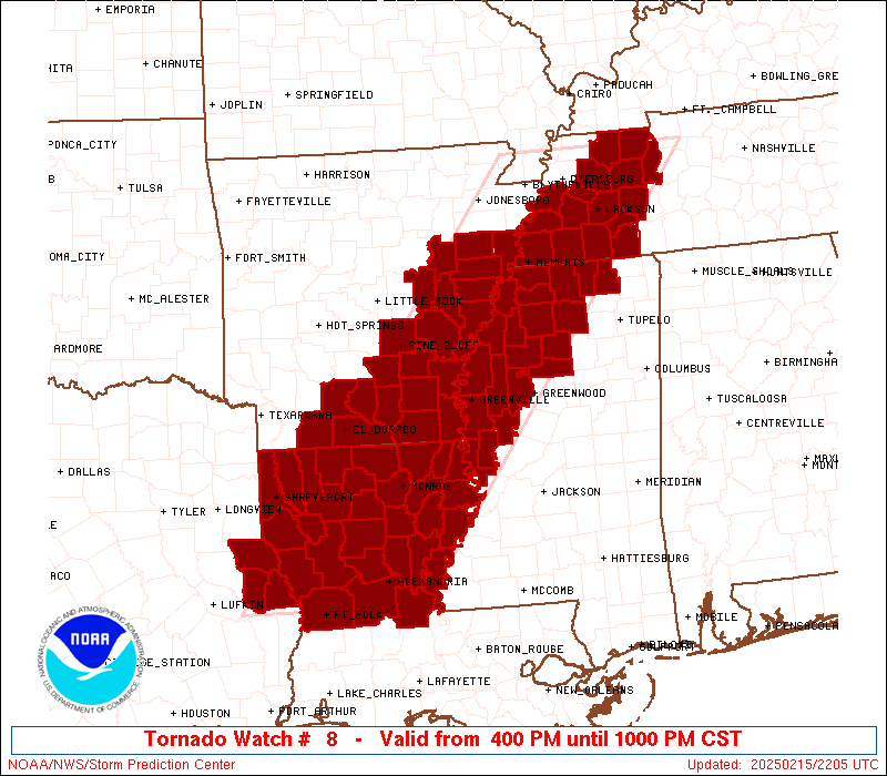
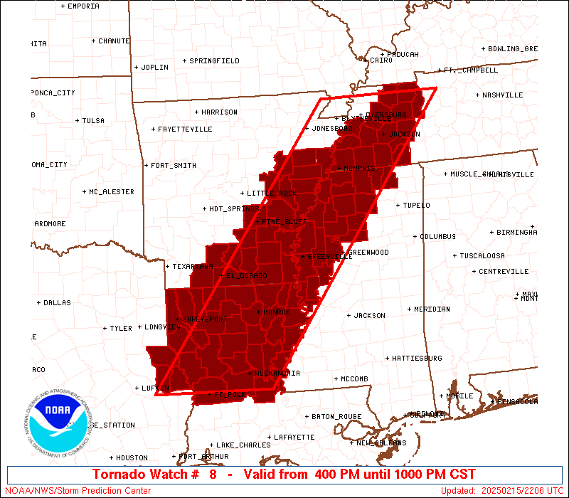
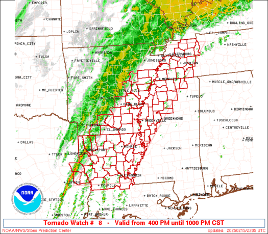
Tornado Watch Number 8
NWS Storm Prediction Center Norman OK
400 PM CST Sat Feb 15 2025
The NWS Storm Prediction Center has issued a
* Tornado Watch for portions of
Eastern and Southeast Arkansas
Northern and Central Louisiana
Northwest Mississippi
Western Tennessee
East Texas
* Effective this Saturday afternoon and evening from 400 PM until
1000 PM CST.
* Primary threats include...
A few tornadoes likely with a couple intense tornadoes possible
Scattered damaging wind gusts to 70 mph likely
Isolated large hail events to 1.5 inches in diameter possible
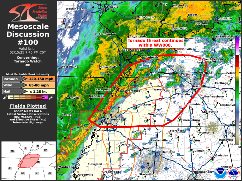
SUMMARY...An intensifying squall line will move generally in a west
to east direction through the late evening. The greatest severe
risk will be with bowing segments or embedded supercells or
mesovortices within the squall line, where damaging gusts are likely
and a threat for a tornadoes may exist.
The tornado watch area is approximately along and 75 statute miles
east and west of a line from 35 miles northeast of Dyersburg TN to
45 miles south of Natchitoches LA. For a complete depiction of the
watch see the associated watch outline update (WOUS64 KWNS WOU8).
PRECAUTIONARY/PREPAREDNESS ACTIONS...
REMEMBER...A Tornado Watch means conditions are favorable for
tornadoes and severe thunderstorms in and close to the watch
area. Persons in these areas should be on the lookout for
threatening weather conditions and listen for later statements
and possible warnings.
&&
AVIATION...Tornadoes and a few severe thunderstorms with hail
surface and aloft to 1.5 inches. Extreme turbulence and surface wind
gusts to 60 knots. A few cumulonimbi with maximum tops to 400. Mean
storm motion vector 21055.
...Smith
   SEL8

   URGENT - IMMEDIATE BROADCAST REQUESTED
   Tornado Watch Number 8
   NWS Storm Prediction Center Norman OK
   400 PM CST Sat Feb 15 2025

   The NWS Storm Prediction Center has issued a

   * Tornado Watch for portions of
     Eastern and Southeast Arkansas
     Northern and Central Louisiana
     Northwest Mississippi
     Western Tennessee
     East Texas

   * Effective this Saturday afternoon and evening from 400 PM until
     1000 PM CST.

   * Primary threats include...
     A few tornadoes likely with a couple intense tornadoes possible
     Scattered damaging wind gusts to 70 mph likely
     Isolated large hail events to 1.5 inches in diameter possible

   SUMMARY...An intensifying squall line will move generally in a west
   to east direction through the late evening.  The greatest severe
   risk will be with bowing segments or embedded supercells or
   mesovortices within the squall line, where damaging gusts are likely
   and a threat for a tornadoes may exist.

   The tornado watch area is approximately along and 75 statute miles
   east and west of a line from 35 miles northeast of Dyersburg TN to
   45 miles south of Natchitoches LA. For a complete depiction of the
   watch see the associated watch outline update (WOUS64 KWNS WOU8).

   PRECAUTIONARY/PREPAREDNESS ACTIONS...

   REMEMBER...A Tornado Watch means conditions are favorable for
   tornadoes and severe thunderstorms in and close to the watch
   area. Persons in these areas should be on the lookout for
   threatening weather conditions and listen for later statements
   and possible warnings.

   &&

   AVIATION...Tornadoes and a few severe thunderstorms with hail
   surface and aloft to 1.5 inches. Extreme turbulence and surface wind
   gusts to 60 knots. A few cumulonimbi with maximum tops to 400. Mean
   storm motion vector 21055.

   ...Smith
 Note:
The Aviation Watch (SAW) product is an approximation to the watch area.
The actual watch is depicted by the shaded areas.
Note:
The Aviation Watch (SAW) product is an approximation to the watch area.
The actual watch is depicted by the shaded areas.
   SAW8
   WW 8 TORNADO AR LA MS TN TX 152200Z - 160400Z
   AXIS..75 STATUTE MILES EAST AND WEST OF LINE..
   35NE DYR/DYERSBURG TN/ - 45S IER/NATCHITOCHES LA/
   ..AVIATION COORDS.. 65NM E/W /27NE DYR - 32WSW AEX/
   HAIL SURFACE AND ALOFT..1.5 INCHES. WIND GUSTS..60 KNOTS.
   MAX TOPS TO 400. MEAN STORM MOTION VECTOR 21055.

   LAT...LON 36348761 31089183 31089437 36349030

   THIS IS AN APPROXIMATION TO THE WATCH AREA.  FOR A
   COMPLETE DEPICTION OF THE WATCH SEE WOUS64 KWNS
   FOR WOU8.
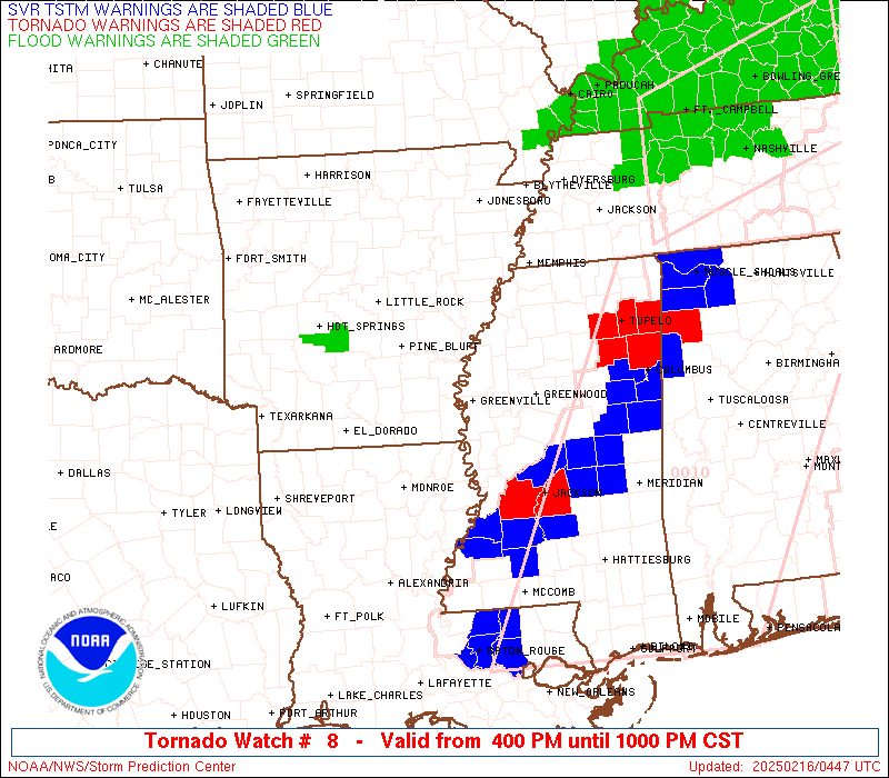
Watch 8 Status Report Messages:
STATUS REPORT #3 ON WW 8

VALID 160325Z - 160440Z

SEVERE WEATHER THREAT CONTINUES RIGHT OF A LINE FROM 25 SSE ESF
TO 15 ESE GLH TO 20 SW CKV.

..SPC..02/16/25

ATTN...WFO...LZK...JAN...SHV...MEG...LCH...

&&

STATUS REPORT FOR WT 8

SEVERE WEATHER THREAT CONTINUES FOR THE FOLLOWING AREAS

LAC009-029-065-107-160440-

LA
.    LOUISIANA PARISHES INCLUDED ARE

AVOYELLES	     CONCORDIA		 MADISON
TENSAS
$$


MSC003-009-013-015-043-051-053-055-071-083-097-115-117-125-139-
145-149-161-163-160440-

MS
.    MISSISSIPPI COUNTIES INCLUDED ARE

ALCORN		     BENTON		 CALHOUN
CARROLL 	     GRENADA		 HOLMES
HUMPHREYS	     ISSAQUENA		 LAFAYETTE
LEFLORE 	     MONTGOMERY 	 PONTOTOC
PRENTISS	     SHARKEY		 TIPPAH
UNION		     WARREN		 YALOBUSHA
YAZOO
$$


TNC023-039-071-077-109-160440-

TN
.    TENNESSEE COUNTIES INCLUDED ARE

CHESTER 	     DECATUR		 HARDIN
HENDERSON	     MCNAIRY
$$


THE WATCH STATUS MESSAGE IS FOR GUIDANCE PURPOSES ONLY.  PLEASE
REFER TO WATCH COUNTY NOTIFICATION STATEMENTS FOR OFFICIAL
INFORMATION ON COUNTIES...INDEPENDENT CITIES AND MARINE ZONES
CLEARED FROM SEVERE THUNDERSTORM AND TORNADO WATCHES.
$$

STATUS REPORT #2 ON WW 8

VALID 160145Z - 160240Z

SEVERE WEATHER THREAT CONTINUES RIGHT OF A LINE FROM 20 W POE TO
40 SW MLU TO 15 SSW LLQ TO 30 ESE PBF TO 60 SW MEM TO 50 ENE DYR.

..SPC..02/16/25

ATTN...WFO...LZK...JAN...SHV...MEG...LCH...

&&

STATUS REPORT FOR WT 8

SEVERE WEATHER THREAT CONTINUES FOR THE FOLLOWING AREAS

ARC003-017-041-043-160240-

AR
.    ARKANSAS COUNTIES INCLUDED ARE

ASHLEY		     CHICOT		 DESHA
DREW
$$


LAC009-021-025-029-035-041-043-049-059-065-067-069-073-079-083-
107-115-123-127-160240-

LA
.    LOUISIANA PARISHES INCLUDED ARE

AVOYELLES	     CALDWELL		 CATAHOULA
CONCORDIA	     EAST CARROLL	 FRANKLIN
GRANT		     JACKSON		 LA SALLE
MADISON 	     MOREHOUSE		 NATCHITOCHES
OUACHITA	     RAPIDES		 RICHLAND
TENSAS		     VERNON		 WEST CARROLL
WINN
$$


MSC003-009-011-013-015-027-033-043-051-053-055-071-083-093-097-
107-115-117-119-125-133-135-137-139-143-145-149-151-161-163-
160240-

MS
.    MISSISSIPPI COUNTIES INCLUDED ARE

ALCORN		     BENTON		 BOLIVAR
CALHOUN 	     CARROLL		 COAHOMA
DESOTO		     GRENADA		 HOLMES
HUMPHREYS	     ISSAQUENA		 LAFAYETTE
LEFLORE 	     MARSHALL		 MONTGOMERY
PANOLA		     PONTOTOC		 PRENTISS
QUITMAN 	     SHARKEY		 SUNFLOWER
TALLAHATCHIE	     TATE		 TIPPAH
TUNICA		     UNION		 WARREN
WASHINGTON	     YALOBUSHA		 YAZOO
$$


TNC005-017-023-033-039-047-053-069-071-075-077-079-097-109-113-
157-167-183-160240-

TN
.    TENNESSEE COUNTIES INCLUDED ARE

BENTON		     CARROLL		 CHESTER
CROCKETT	     DECATUR		 FAYETTE
GIBSON		     HARDEMAN		 HARDIN
HAYWOOD 	     HENDERSON		 HENRY
LAUDERDALE	     MCNAIRY		 MADISON
SHELBY		     TIPTON		 WEAKLEY
$$


THE WATCH STATUS MESSAGE IS FOR GUIDANCE PURPOSES ONLY.  PLEASE
REFER TO WATCH COUNTY NOTIFICATION STATEMENTS FOR OFFICIAL
INFORMATION ON COUNTIES...INDEPENDENT CITIES AND MARINE ZONES
CLEARED FROM SEVERE THUNDERSTORM AND TORNADO WATCHES.
$$

STATUS REPORT #1 ON WW 8

VALID 152250Z - 152340Z

THE SEVERE WEATHER THREAT CONTINUES ACROSS THE ENTIRE WATCH AREA.

..LYONS..02/15/25

ATTN...WFO...LZK...JAN...SHV...MEG...LCH...

&&

STATUS REPORT FOR WT 8

SEVERE WEATHER THREAT CONTINUES FOR THE FOLLOWING AREAS

ARC001-003-011-013-017-025-027-035-037-041-043-069-077-079-095-
103-107-117-123-139-147-152340-

AR
.    ARKANSAS COUNTIES INCLUDED ARE

ARKANSAS	     ASHLEY		 BRADLEY
CALHOUN 	     CHICOT		 CLEVELAND
COLUMBIA	     CRITTENDEN 	 CROSS
DESHA		     DREW		 JEFFERSON
LEE		     LINCOLN		 MONROE
OUACHITA	     PHILLIPS		 PRAIRIE
ST. FRANCIS	     UNION		 WOODRUFF
$$


LAC009-013-015-017-021-025-027-029-031-035-041-043-049-059-061-
065-067-069-073-079-081-083-085-107-111-115-119-123-127-
152340-

LA
.    LOUISIANA PARISHES INCLUDED ARE

AVOYELLES	     BIENVILLE		 BOSSIER
CADDO		     CALDWELL		 CATAHOULA
CLAIBORNE	     CONCORDIA		 DE SOTO
EAST CARROLL	     FRANKLIN		 GRANT
JACKSON 	     LA SALLE		 LINCOLN
MADISON 	     MOREHOUSE		 NATCHITOCHES
OUACHITA	     RAPIDES		 RED RIVER
RICHLAND	     SABINE		 TENSAS
UNION		     VERNON		 WEBSTER
WEST CARROLL	     WINN
$$


MSC009-011-027-033-043-053-055-071-083-093-107-119-125-133-135-
137-139-143-151-161-152340-

MS
.    MISSISSIPPI COUNTIES INCLUDED ARE

BENTON		     BOLIVAR		 COAHOMA
DESOTO		     GRENADA		 HUMPHREYS
ISSAQUENA	     LAFAYETTE		 LEFLORE
MARSHALL	     PANOLA		 QUITMAN
SHARKEY 	     SUNFLOWER		 TALLAHATCHIE
TATE		     TIPPAH		 TUNICA
WASHINGTON	     YALOBUSHA
$$


TNC005-017-023-033-047-053-069-075-077-079-097-109-113-157-167-
183-152340-

TN
.    TENNESSEE COUNTIES INCLUDED ARE

BENTON		     CARROLL		 CHESTER
CROCKETT	     FAYETTE		 GIBSON
HARDEMAN	     HAYWOOD		 HENDERSON
HENRY		     LAUDERDALE 	 MCNAIRY
MADISON 	     SHELBY		 TIPTON
WEAKLEY
$$


TXC403-405-419-152340-

TX
.    TEXAS COUNTIES INCLUDED ARE

SABINE		     SAN AUGUSTINE	 SHELBY
$$


THE WATCH STATUS MESSAGE IS FOR GUIDANCE PURPOSES ONLY.  PLEASE
REFER TO WATCH COUNTY NOTIFICATION STATEMENTS FOR OFFICIAL
INFORMATION ON COUNTIES...INDEPENDENT CITIES AND MARINE ZONES
CLEARED FROM SEVERE THUNDERSTORM AND TORNADO WATCHES.
$$
Note:
Click for Complete Product Text.
Tornadoes
Probability of 2 or more tornadoes
|
Mod (60%)
|
Probability of 1 or more strong (EF2-EF5) tornadoes
|
Mod (30%)
|
Wind
Probability of 10 or more severe wind events
|
Mod (60%)
|
Probability of 1 or more wind events > 65 knots
|
Low (20%)
|
Hail
Probability of 10 or more severe hail events
|
Low (20%)
|
Probability of 1 or more hailstones > 2 inches
|
Low (20%)
|
Combined Severe Hail/Wind
Probability of 6 or more combined severe hail/wind events
|
High (80%)
|
For each watch, probabilities for particular events inside the watch
(listed above in each table) are determined by the issuing forecaster.
The "Low" category contains probability values ranging from less than 2%
to 20% (EF2-EF5 tornadoes), less than 5% to 20% (all other probabilities),
"Moderate" from 30% to 60%, and "High" from 70% to greater than 95%.
High values are bolded and lighter in color to provide awareness of
an increased threat for a particular event.


 @NWSSPC