 Note:
The expiration time in the watch graphic is amended if the watch is
replaced, cancelled or extended.
Note:
Note:
The expiration time in the watch graphic is amended if the watch is
replaced, cancelled or extended.
Note: Click for
Watch Status Reports.
SEL1
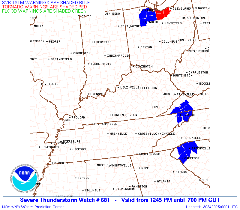
URGENT - IMMEDIATE BROADCAST REQUESTED
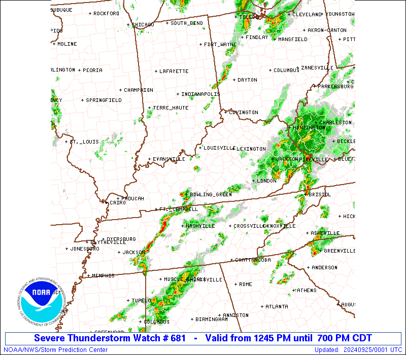
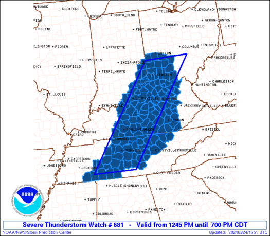
Severe Thunderstorm Watch Number 681
NWS Storm Prediction Center Norman OK
1245 PM CDT Tue Sep 24 2024
The NWS Storm Prediction Center has issued a
* Severe Thunderstorm Watch for portions of
Southeast Indiana
Central and Eastern Kentucky
Southwest Ohio
Tennessee
* Effective this Tuesday afternoon and evening from 1245 PM until
700 PM CDT.
* Primary threats include...
Scattered damaging wind gusts to 70 mph likely
Isolated large hail events to 1.5 inches in diameter possible
A tornado or two possible
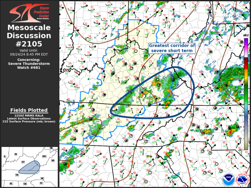
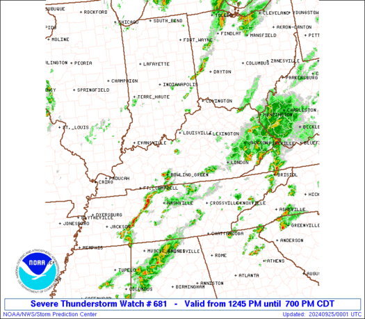
SUMMARY...Scattered strong to severe storms will continue to develop
this afternoon across a broad region, with damaging winds and some
hail as the most common hazards.
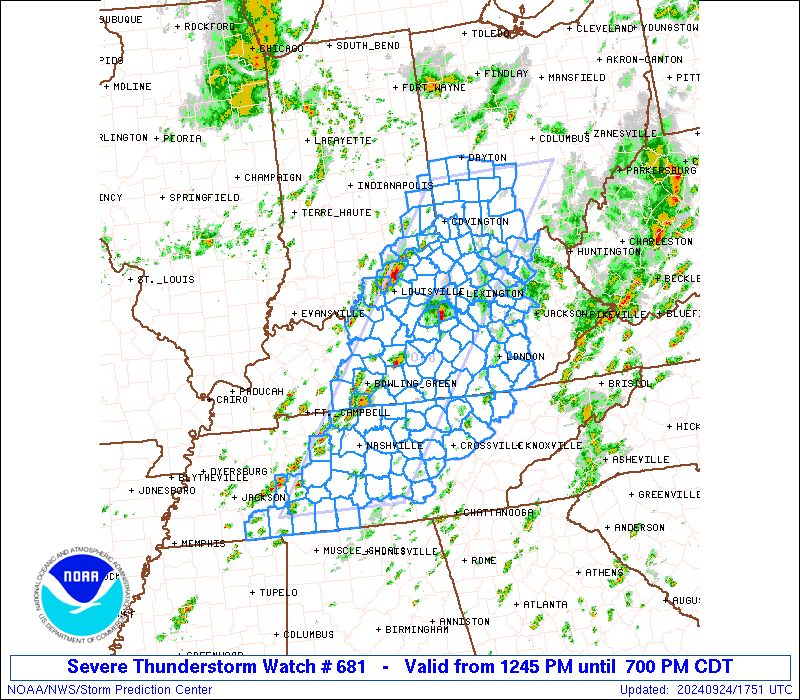
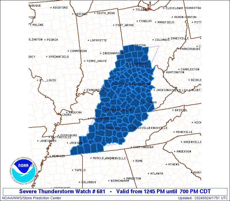
The severe thunderstorm watch area is approximately along and 60
statute miles east and west of a line from 55 miles northeast of
Cincinnati OH to 65 miles south southwest of Nashville TN. For a
complete depiction of the watch see the associated watch outline
update (WOUS64 KWNS WOU1).
PRECAUTIONARY/PREPAREDNESS ACTIONS...
REMEMBER...A Severe Thunderstorm Watch means conditions are
favorable for severe thunderstorms in and close to the watch area.
Persons in these areas should be on the lookout for threatening
weather conditions and listen for later statements and possible
warnings. Severe thunderstorms can and occasionally do produce
tornadoes.
&&
AVIATION...A few severe thunderstorms with hail surface and aloft to
1.5 inches. Extreme turbulence and surface wind gusts to 60 knots. A
few cumulonimbi with maximum tops to 500. Mean storm motion vector
24030.
...Guyer

   SEL1

   URGENT - IMMEDIATE BROADCAST REQUESTED
   Severe Thunderstorm Watch Number 681
   NWS Storm Prediction Center Norman OK
   1245 PM CDT Tue Sep 24 2024

   The NWS Storm Prediction Center has issued a

   * Severe Thunderstorm Watch for portions of
     Southeast Indiana
     Central and Eastern Kentucky
     Southwest Ohio
     Tennessee

   * Effective this Tuesday afternoon and evening from 1245 PM until
     700 PM CDT.

   * Primary threats include...
     Scattered damaging wind gusts to 70 mph likely
     Isolated large hail events to 1.5 inches in diameter possible
     A tornado or two possible

   SUMMARY...Scattered strong to severe storms will continue to develop
   this afternoon across a broad region, with damaging winds and some
   hail as the most common hazards.

   The severe thunderstorm watch area is approximately along and 60
   statute miles east and west of a line from 55 miles northeast of
   Cincinnati OH to 65 miles south southwest of Nashville TN. For a
   complete depiction of the watch see the associated watch outline
   update (WOUS64 KWNS WOU1).

   PRECAUTIONARY/PREPAREDNESS ACTIONS...

   REMEMBER...A Severe Thunderstorm Watch means conditions are
   favorable for severe thunderstorms in and close to the watch area.
   Persons in these areas should be on the lookout for threatening
   weather conditions and listen for later statements and possible
   warnings. Severe thunderstorms can and occasionally do produce
   tornadoes.

   &&

   AVIATION...A few severe thunderstorms with hail surface and aloft to
   1.5 inches. Extreme turbulence and surface wind gusts to 60 knots. A
   few cumulonimbi with maximum tops to 500. Mean storm motion vector
   24030.

   ...Guyer
 Note:
The Aviation Watch (SAW) product is an approximation to the watch area.
The actual watch is depicted by the shaded areas.
Note:
The Aviation Watch (SAW) product is an approximation to the watch area.
The actual watch is depicted by the shaded areas.
   SAW1
   WW 681 SEVERE TSTM IN KY OH TN 241745Z - 250000Z
   AXIS..60 STATUTE MILES EAST AND WEST OF LINE..
   55NE LUK/CINCINNATI OH/ - 65SSW BNA/NASHVILLE TN/
   ..AVIATION COORDS.. 50NM E/W /41SSE ROD - 38NNE MSL/
   HAIL SURFACE AND ALOFT..1.5 INCHES. WIND GUSTS..60 KNOTS.
   MAX TOPS TO 500. MEAN STORM MOTION VECTOR 24030.

   LAT...LON 39668256 35258606 35258818 39668482

   THIS IS AN APPROXIMATION TO THE WATCH AREA.  FOR A
   COMPLETE DEPICTION OF THE WATCH SEE WOUS64 KWNS
   FOR WOU1.
Watch 681 Status Report Messages:
STATUS REPORT #3 ON WW 681

VALID 242210Z - 242340Z

THE SEVERE WEATHER THREAT CONTINUES ACROSS THE ENTIRE WATCH AREA.

..SPC..09/24/24

ATTN...WFO...LMK...ILN...JKL...OHX...MRX...MEG...

&&

STATUS REPORT FOR WS 681

SEVERE WEATHER THREAT CONTINUES FOR THE FOLLOWING AREAS

INC019-029-047-077-115-137-143-155-161-242340-

IN
.    INDIANA COUNTIES INCLUDED ARE

CLARK		     DEARBORN		 FRANKLIN
JEFFERSON	     OHIO		 RIPLEY
SCOTT		     SWITZERLAND	 UNION
$$


KYC001-003-005-009-011-013-015-017-021-023-029-037-041-045-049-
051-053-057-061-065-067-069-073-077-079-081-085-087-093-097-099-
103-109-111-113-117-121-123-125-129-135-137-141-147-151-155-161-
165-167-169-171-173-179-181-185-187-189-191-197-199-201-203-205-
207-209-211-213-215-217-223-227-229-231-235-237-239-242340-

KY
.    KENTUCKY COUNTIES INCLUDED ARE

ADAIR		     ALLEN		 ANDERSON
BARREN		     BATH		 BELL
BOONE		     BOURBON		 BOYLE
BRACKEN 	     BULLITT		 CAMPBELL
CARROLL 	     CASEY		 CLARK
CLAY		     CLINTON		 CUMBERLAND
EDMONSON	     ESTILL		 FAYETTE
FLEMING 	     FRANKLIN		 GALLATIN
GARRARD 	     GRANT		 GRAYSON
GREEN		     HARDIN		 HARRISON
HART		     HENRY		 JACKSON
JEFFERSON	     JESSAMINE		 KENTON
KNOX		     LARUE		 LAUREL
LEE		     LEWIS		 LINCOLN
LOGAN		     MCCREARY		 MADISON
MARION		     MASON		 MENIFEE
MERCER		     METCALFE		 MONROE
MONTGOMERY	     NELSON		 NICHOLAS
OLDHAM		     OWEN		 OWSLEY
PENDLETON	     POWELL		 PULASKI
ROBERTSON	     ROCKCASTLE 	 ROWAN
RUSSELL 	     SCOTT		 SHELBY
SIMPSON 	     SPENCER		 TAYLOR
TRIMBLE 	     WARREN		 WASHINGTON
WAYNE		     WHITLEY		 WOLFE
WOODFORD
$$


OHC001-015-017-025-027-047-057-061-071-113-135-165-242340-

OH
.    OHIO COUNTIES INCLUDED ARE

ADAMS		     BROWN		 BUTLER
CLERMONT	     CLINTON		 FAYETTE
GREENE		     HAMILTON		 HIGHLAND
MONTGOMERY	     PREBLE		 WARREN
$$


TNC003-013-015-021-027-031-035-037-039-041-043-049-055-061-071-
081-087-099-101-109-111-117-119-129-133-135-137-141-147-149-151-
159-165-169-175-177-181-185-187-189-242340-

TN
.    TENNESSEE COUNTIES INCLUDED ARE

BEDFORD 	     CAMPBELL		 CANNON
CHEATHAM	     CLAY		 COFFEE
CUMBERLAND	     DAVIDSON		 DECATUR
DE KALB 	     DICKSON		 FENTRESS
GILES		     GRUNDY		 HARDIN
HICKMAN 	     JACKSON		 LAWRENCE
LEWIS		     MCNAIRY		 MACON
MARSHALL	     MAURY		 MORGAN
OVERTON 	     PERRY		 PICKETT
PUTNAM		     ROBERTSON		 RUTHERFORD
SCOTT		     SMITH		 SUMNER
TROUSDALE	     VAN BUREN		 WARREN
WAYNE		     WHITE		 WILLIAMSON
WILSON
$$


THE WATCH STATUS MESSAGE IS FOR GUIDANCE PURPOSES ONLY.  PLEASE
REFER TO WATCH COUNTY NOTIFICATION STATEMENTS FOR OFFICIAL
INFORMATION ON COUNTIES...INDEPENDENT CITIES AND MARINE ZONES
CLEARED FROM SEVERE THUNDERSTORM AND TORNADO WATCHES.
$$

STATUS REPORT #2 ON WW 681

VALID 242035Z - 242140Z

SEVERE WEATHER THREAT CONTINUES RIGHT OF A LINE FROM 45 SSW CKV
TO 35 SSW SDF TO 50 W LUK.

..GOSS..09/24/24

ATTN...WFO...LMK...ILN...JKL...OHX...MRX...MEG...

&&

STATUS REPORT FOR WS 681

SEVERE WEATHER THREAT CONTINUES FOR THE FOLLOWING AREAS

INC019-029-047-077-115-137-143-155-161-242140-

IN
.    INDIANA COUNTIES INCLUDED ARE

CLARK		     DEARBORN		 FRANKLIN
JEFFERSON	     OHIO		 RIPLEY
SCOTT		     SWITZERLAND	 UNION
$$


KYC001-003-005-009-011-013-015-017-021-023-029-037-041-045-049-
051-053-057-061-065-067-069-073-077-079-081-085-087-093-097-099-
103-109-111-113-117-121-123-125-129-135-137-141-147-151-155-161-
165-167-169-171-173-179-181-185-187-189-191-197-199-201-203-205-
207-209-211-213-215-217-223-227-229-231-235-237-239-242140-

KY
.    KENTUCKY COUNTIES INCLUDED ARE

ADAIR		     ALLEN		 ANDERSON
BARREN		     BATH		 BELL
BOONE		     BOURBON		 BOYLE
BRACKEN 	     BULLITT		 CAMPBELL
CARROLL 	     CASEY		 CLARK
CLAY		     CLINTON		 CUMBERLAND
EDMONSON	     ESTILL		 FAYETTE
FLEMING 	     FRANKLIN		 GALLATIN
GARRARD 	     GRANT		 GRAYSON
GREEN		     HARDIN		 HARRISON
HART		     HENRY		 JACKSON
JEFFERSON	     JESSAMINE		 KENTON
KNOX		     LARUE		 LAUREL
LEE		     LEWIS		 LINCOLN
LOGAN		     MCCREARY		 MADISON
MARION		     MASON		 MENIFEE
MERCER		     METCALFE		 MONROE
MONTGOMERY	     NELSON		 NICHOLAS
OLDHAM		     OWEN		 OWSLEY
PENDLETON	     POWELL		 PULASKI
ROBERTSON	     ROCKCASTLE 	 ROWAN
RUSSELL 	     SCOTT		 SHELBY
SIMPSON 	     SPENCER		 TAYLOR
TRIMBLE 	     WARREN		 WASHINGTON
WAYNE		     WHITLEY		 WOLFE
WOODFORD
$$


OHC001-015-017-025-027-047-057-061-071-113-135-165-242140-

OH
.    OHIO COUNTIES INCLUDED ARE

ADAMS		     BROWN		 BUTLER
CLERMONT	     CLINTON		 FAYETTE
GREENE		     HAMILTON		 HIGHLAND
MONTGOMERY	     PREBLE		 WARREN
$$


TNC003-013-015-021-027-031-035-037-039-041-043-049-055-061-071-
081-087-099-101-109-111-117-119-129-133-135-137-141-147-149-151-
159-165-169-175-177-181-185-187-189-242140-

TN
.    TENNESSEE COUNTIES INCLUDED ARE

BEDFORD 	     CAMPBELL		 CANNON
CHEATHAM	     CLAY		 COFFEE
CUMBERLAND	     DAVIDSON		 DECATUR
DE KALB 	     DICKSON		 FENTRESS
GILES		     GRUNDY		 HARDIN
HICKMAN 	     JACKSON		 LAWRENCE
LEWIS		     MCNAIRY		 MACON
MARSHALL	     MAURY		 MORGAN
OVERTON 	     PERRY		 PICKETT
PUTNAM		     ROBERTSON		 RUTHERFORD
SCOTT		     SMITH		 SUMNER
TROUSDALE	     VAN BUREN		 WARREN
WAYNE		     WHITE		 WILLIAMSON
WILSON
$$


THE WATCH STATUS MESSAGE IS FOR GUIDANCE PURPOSES ONLY.  PLEASE
REFER TO WATCH COUNTY NOTIFICATION STATEMENTS FOR OFFICIAL
INFORMATION ON COUNTIES...INDEPENDENT CITIES AND MARINE ZONES
CLEARED FROM SEVERE THUNDERSTORM AND TORNADO WATCHES.
$$

STATUS REPORT #1 ON WW 681

VALID 241950Z - 242040Z

THE SEVERE WEATHER THREAT CONTINUES ACROSS THE ENTIRE WATCH AREA.

..GOSS..09/24/24

ATTN...WFO...LMK...ILN...JKL...OHX...MRX...MEG...

&&

STATUS REPORT FOR WS 681

SEVERE WEATHER THREAT CONTINUES FOR THE FOLLOWING AREAS

INC019-029-043-047-061-077-115-137-143-155-161-242040-

IN
.    INDIANA COUNTIES INCLUDED ARE

CLARK		     DEARBORN		 FLOYD
FRANKLIN	     HARRISON		 JEFFERSON
OHIO		     RIPLEY		 SCOTT
SWITZERLAND	     UNION
$$


KYC001-003-005-009-011-013-015-017-021-023-027-029-031-037-041-
045-049-051-053-057-061-065-067-069-073-077-079-081-085-087-093-
097-099-103-109-111-113-117-121-123-125-129-135-137-141-147-151-
155-161-163-165-167-169-171-173-179-181-185-187-189-191-197-199-
201-203-205-207-209-211-213-215-217-223-227-229-231-235-237-239-
242040-

KY
.    KENTUCKY COUNTIES INCLUDED ARE

ADAIR		     ALLEN		 ANDERSON
BARREN		     BATH		 BELL
BOONE		     BOURBON		 BOYLE
BRACKEN 	     BRECKINRIDGE	 BULLITT
BUTLER		     CAMPBELL		 CARROLL
CASEY		     CLARK		 CLAY
CLINTON 	     CUMBERLAND 	 EDMONSON
ESTILL		     FAYETTE		 FLEMING
FRANKLIN	     GALLATIN		 GARRARD
GRANT		     GRAYSON		 GREEN
HARDIN		     HARRISON		 HART
HENRY		     JACKSON		 JEFFERSON
JESSAMINE	     KENTON		 KNOX
LARUE		     LAUREL		 LEE
LEWIS		     LINCOLN		 LOGAN
MCCREARY	     MADISON		 MARION
MASON		     MEADE		 MENIFEE
MERCER		     METCALFE		 MONROE
MONTGOMERY	     NELSON		 NICHOLAS
OLDHAM		     OWEN		 OWSLEY
PENDLETON	     POWELL		 PULASKI
ROBERTSON	     ROCKCASTLE 	 ROWAN
RUSSELL 	     SCOTT		 SHELBY
SIMPSON 	     SPENCER		 TAYLOR
TRIMBLE 	     WARREN		 WASHINGTON
WAYNE		     WHITLEY		 WOLFE
WOODFORD
$$


OHC001-015-017-025-027-047-057-061-071-113-135-165-242040-

OH
.    OHIO COUNTIES INCLUDED ARE

ADAMS		     BROWN		 BUTLER
CLERMONT	     CLINTON		 FAYETTE
GREENE		     HAMILTON		 HIGHLAND
MONTGOMERY	     PREBLE		 WARREN
$$


TNC003-013-015-021-027-031-035-037-039-041-043-049-055-061-071-
081-087-099-101-109-111-117-119-129-133-135-137-141-147-149-151-
159-165-169-175-177-181-185-187-189-242040-

TN
.    TENNESSEE COUNTIES INCLUDED ARE

BEDFORD 	     CAMPBELL		 CANNON
CHEATHAM	     CLAY		 COFFEE
CUMBERLAND	     DAVIDSON		 DECATUR
DE KALB 	     DICKSON		 FENTRESS
GILES		     GRUNDY		 HARDIN
HICKMAN 	     JACKSON		 LAWRENCE
LEWIS		     MCNAIRY		 MACON
MARSHALL	     MAURY		 MORGAN
OVERTON 	     PERRY		 PICKETT
PUTNAM		     ROBERTSON		 RUTHERFORD
SCOTT		     SMITH		 SUMNER
TROUSDALE	     VAN BUREN		 WARREN
WAYNE		     WHITE		 WILLIAMSON
WILSON
$$


THE WATCH STATUS MESSAGE IS FOR GUIDANCE PURPOSES ONLY.  PLEASE
REFER TO WATCH COUNTY NOTIFICATION STATEMENTS FOR OFFICIAL
INFORMATION ON COUNTIES...INDEPENDENT CITIES AND MARINE ZONES
CLEARED FROM SEVERE THUNDERSTORM AND TORNADO WATCHES.
$$
Note:
Click for Complete Product Text.
Tornadoes
Probability of 2 or more tornadoes
|
Low (20%)
|
Probability of 1 or more strong (EF2-EF5) tornadoes
|
Low (10%)
|
Wind
Probability of 10 or more severe wind events
|
High (70%)
|
Probability of 1 or more wind events > 65 knots
|
Low (20%)
|
Hail
Probability of 10 or more severe hail events
|
Low (20%)
|
Probability of 1 or more hailstones > 2 inches
|
Low (10%)
|
Combined Severe Hail/Wind
Probability of 6 or more combined severe hail/wind events
|
High (>95%)
|
For each watch, probabilities for particular events inside the watch
(listed above in each table) are determined by the issuing forecaster.
The "Low" category contains probability values ranging from less than 2%
to 20% (EF2-EF5 tornadoes), less than 5% to 20% (all other probabilities),
"Moderate" from 30% to 60%, and "High" from 70% to greater than 95%.
High values are bolded and lighter in color to provide awareness of
an increased threat for a particular event.


 @NWSSPC