 Note:
The expiration time in the watch graphic is amended if the watch is
replaced, cancelled or extended.
Note:
Note:
The expiration time in the watch graphic is amended if the watch is
replaced, cancelled or extended.
Note: Click for
Watch Status Reports.
SEL5
URGENT - IMMEDIATE BROADCAST REQUESTED
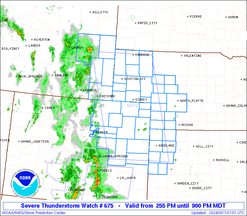
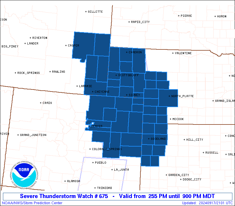
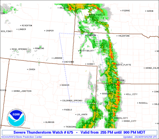
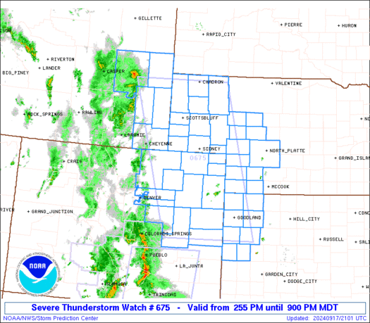
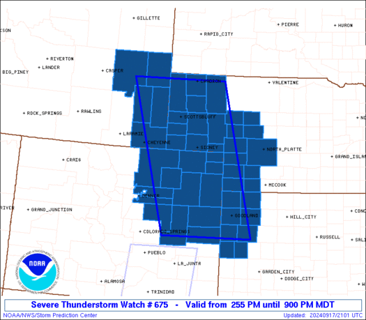
Severe Thunderstorm Watch Number 675
NWS Storm Prediction Center Norman OK
255 PM MDT Tue Sep 17 2024
The NWS Storm Prediction Center has issued a
* Severe Thunderstorm Watch for portions of
Northeast and East-Central Colorado
Northwest Kansas
Western Nebraska
Eastern Wyoming
* Effective this Tuesday afternoon and evening from 255 PM until
900 PM MDT.
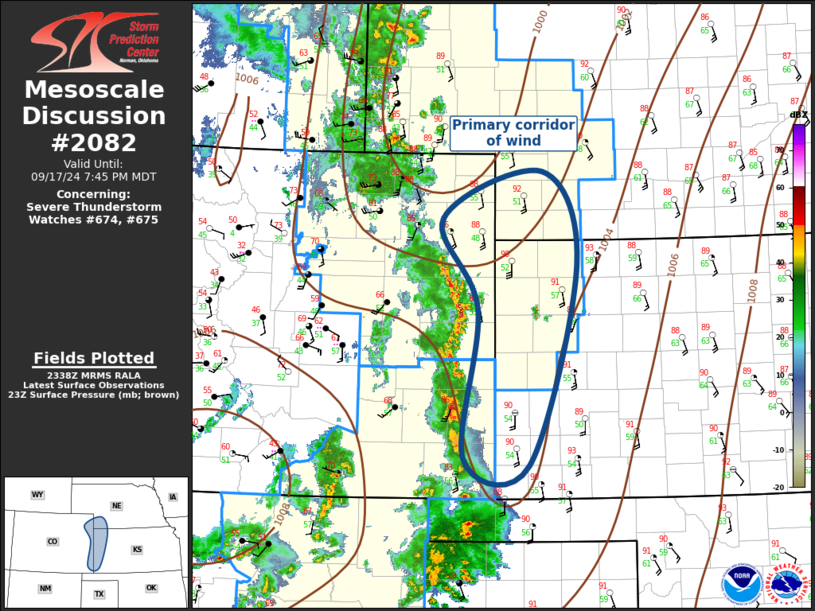
* Primary threats include...
Widespread damaging winds likely with isolated significant gusts
to 80 mph possible
Isolated large hail events to 1 inch in diameter possible
SUMMARY...High-based convection should gradually increase in
coverage and intensity as it spreads northeastward across the
central High Plains this afternoon and evening. Numerous strong to
severe wind gusts should be the main threat with this activity, with
the highest gusts potentially reaching up to 70-80 mph.
The severe thunderstorm watch area is approximately along and 80
statute miles east and west of a line from 35 miles south southwest
of Burlington CO to 60 miles north northeast of Torrington WY. For a
complete depiction of the watch see the associated watch outline
update (WOUS64 KWNS WOU5).
PRECAUTIONARY/PREPAREDNESS ACTIONS...
REMEMBER...A Severe Thunderstorm Watch means conditions are
favorable for severe thunderstorms in and close to the watch area.
Persons in these areas should be on the lookout for threatening
weather conditions and listen for later statements and possible
warnings. Severe thunderstorms can and occasionally do produce
tornadoes.
&&
OTHER WATCH INFORMATION...CONTINUE...WW 674...
AVIATION...A few severe thunderstorms with hail surface and aloft to
1 inch. Extreme turbulence and surface wind gusts to 70 knots. A few
cumulonimbi with maximum tops to 500. Mean storm motion vector
24040.
...Gleason
   SEL5

   URGENT - IMMEDIATE BROADCAST REQUESTED
   Severe Thunderstorm Watch Number 675
   NWS Storm Prediction Center Norman OK
   255 PM MDT Tue Sep 17 2024

   The NWS Storm Prediction Center has issued a

   * Severe Thunderstorm Watch for portions of
     Northeast and East-Central Colorado
     Northwest Kansas
     Western Nebraska
     Eastern Wyoming

   * Effective this Tuesday afternoon and evening from 255 PM until
     900 PM MDT.

   * Primary threats include...
     Widespread damaging winds likely with isolated significant gusts
       to 80 mph possible
     Isolated large hail events to 1 inch in diameter possible

   SUMMARY...High-based convection should gradually increase in
   coverage and intensity as it spreads northeastward across the
   central High Plains this afternoon and evening. Numerous strong to
   severe wind gusts should be the main threat with this activity, with
   the highest gusts potentially reaching up to 70-80 mph.

   The severe thunderstorm watch area is approximately along and 80
   statute miles east and west of a line from 35 miles south southwest
   of Burlington CO to 60 miles north northeast of Torrington WY. For a
   complete depiction of the watch see the associated watch outline
   update (WOUS64 KWNS WOU5).

   PRECAUTIONARY/PREPAREDNESS ACTIONS...

   REMEMBER...A Severe Thunderstorm Watch means conditions are
   favorable for severe thunderstorms in and close to the watch area.
   Persons in these areas should be on the lookout for threatening
   weather conditions and listen for later statements and possible
   warnings. Severe thunderstorms can and occasionally do produce
   tornadoes.

   &&

   OTHER WATCH INFORMATION...CONTINUE...WW 674...

   AVIATION...A few severe thunderstorms with hail surface and aloft to
   1 inch. Extreme turbulence and surface wind gusts to 70 knots. A few
   cumulonimbi with maximum tops to 500. Mean storm motion vector
   24040.

   ...Gleason
 Note:
The Aviation Watch (SAW) product is an approximation to the watch area.
The actual watch is depicted by the shaded areas.
Note:
The Aviation Watch (SAW) product is an approximation to the watch area.
The actual watch is depicted by the shaded areas.
SAW5
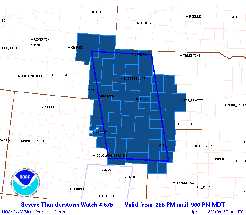
WW 675 SEVERE TSTM CO KS NE WY 172055Z - 180300Z
AXIS..80 STATUTE MILES EAST AND WEST OF LINE..
35SSW ITR/BURLINGTON CO/ - 60NNE TOR/TORRINGTON WY/
..AVIATION COORDS.. 70NM E/W /35NNE LAA - 59N BFF/
HAIL SURFACE AND ALOFT..1 INCH. WIND GUSTS..70 KNOTS.
MAX TOPS TO 500. MEAN STORM MOTION VECTOR 24040.
LAT...LON 38750401 42850528 42850212 38750104
THIS IS AN APPROXIMATION TO THE WATCH AREA. FOR A
COMPLETE DEPICTION OF THE WATCH SEE WOUS64 KWNS
FOR WOU5.
Watch 675 Status Report Messages:
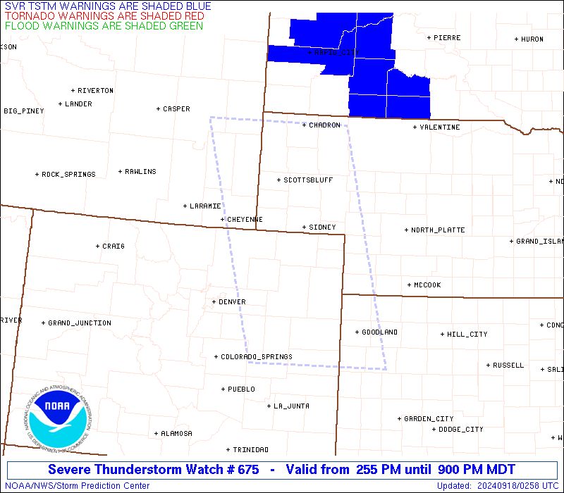
STATUS REPORT #2 ON WW 675

VALID 180020Z - 180140Z

SEVERE WEATHER THREAT CONTINUES RIGHT OF A LINE FROM 35 SSW ITR
TO 35 NNW ITR TO 30 NNE AKO TO 30 WNW SNY TO 10 ENE BFF TO 35 W
CDR.

..SPC..09/18/24

ATTN...WFO...BOU...GLD...LBF...CYS...

&&

STATUS REPORT FOR WS 675

SEVERE WEATHER THREAT CONTINUES FOR THE FOLLOWING AREAS

COC017-063-075-095-115-125-180140-

CO
.    COLORADO COUNTIES INCLUDED ARE

CHEYENNE	     KIT CARSON 	 LOGAN
PHILLIPS	     SEDGWICK		 YUMA
$$


KSC023-071-109-153-181-193-199-203-180140-

KS
.    KANSAS COUNTIES INCLUDED ARE

CHEYENNE	     GREELEY		 LOGAN
RAWLINS 	     SHERMAN		 THOMAS
WALLACE 	     WICHITA
$$


NEC005-007-013-029-033-045-049-057-069-075-085-087-091-101-105-
111-117-123-135-157-161-165-180140-

NE
.    NEBRASKA COUNTIES INCLUDED ARE

ARTHUR		     BANNER		 BOX BUTTE
CHASE		     CHEYENNE		 DAWES
DEUEL		     DUNDY		 GARDEN
GRANT		     HAYES		 HITCHCOCK
HOOKER		     KEITH		 KIMBALL
LINCOLN 	     MCPHERSON		 MORRILL
PERKINS 	     SCOTTS BLUFF	 SHERIDAN
SIOUX
$$


THE WATCH STATUS MESSAGE IS FOR GUIDANCE PURPOSES ONLY.  PLEASE
REFER TO WATCH COUNTY NOTIFICATION STATEMENTS FOR OFFICIAL
INFORMATION ON COUNTIES...INDEPENDENT CITIES AND MARINE ZONES
CLEARED FROM SEVERE THUNDERSTORM AND TORNADO WATCHES.
$$

STATUS REPORT #1 ON WW 675

VALID 172150Z - 172240Z

THE SEVERE WEATHER THREAT CONTINUES ACROSS THE ENTIRE WATCH AREA.

..SPC..09/17/24

ATTN...WFO...BOU...GLD...LBF...CYS...

&&

STATUS REPORT FOR WS 675

SEVERE WEATHER THREAT CONTINUES FOR THE FOLLOWING AREAS

COC001-005-017-039-063-073-075-087-095-115-121-123-125-172240-

CO
.    COLORADO COUNTIES INCLUDED ARE

ADAMS		     ARAPAHOE		 CHEYENNE
ELBERT		     KIT CARSON 	 LINCOLN
LOGAN		     MORGAN		 PHILLIPS
SEDGWICK	     WASHINGTON 	 WELD
YUMA
$$


KSC023-071-109-153-181-193-199-203-172240-

KS
.    KANSAS COUNTIES INCLUDED ARE

CHEYENNE	     GREELEY		 LOGAN
RAWLINS 	     SHERMAN		 THOMAS
WALLACE 	     WICHITA
$$


NEC005-007-013-029-033-045-049-057-069-075-085-087-091-101-105-
111-117-123-135-157-161-165-172240-

NE
.    NEBRASKA COUNTIES INCLUDED ARE

ARTHUR		     BANNER		 BOX BUTTE
CHASE		     CHEYENNE		 DAWES
DEUEL		     DUNDY		 GARDEN
GRANT		     HAYES		 HITCHCOCK
HOOKER		     KEITH		 KIMBALL
LINCOLN 	     MCPHERSON		 MORRILL
PERKINS 	     SCOTTS BLUFF	 SHERIDAN
SIOUX
$$


WYC009-015-021-027-031-172240-

WY
.    WYOMING COUNTIES INCLUDED ARE

CONVERSE	     GOSHEN		 LARAMIE
NIOBRARA	     PLATTE
$$


THE WATCH STATUS MESSAGE IS FOR GUIDANCE PURPOSES ONLY.  PLEASE
REFER TO WATCH COUNTY NOTIFICATION STATEMENTS FOR OFFICIAL
INFORMATION ON COUNTIES...INDEPENDENT CITIES AND MARINE ZONES
CLEARED FROM SEVERE THUNDERSTORM AND TORNADO WATCHES.
$$
Note:
Click for Complete Product Text.
Tornadoes
Probability of 2 or more tornadoes
|
Low (<5%)
|
Probability of 1 or more strong (EF2-EF5) tornadoes
|
Low (<2%)
|
Wind
Probability of 10 or more severe wind events
|
High (80%)
|
Probability of 1 or more wind events > 65 knots
|
Mod (50%)
|
Hail
Probability of 10 or more severe hail events
|
Low (20%)
|
Probability of 1 or more hailstones > 2 inches
|
Low (10%)
|
Combined Severe Hail/Wind
Probability of 6 or more combined severe hail/wind events
|
High (90%)
|
For each watch, probabilities for particular events inside the watch
(listed above in each table) are determined by the issuing forecaster.
The "Low" category contains probability values ranging from less than 2%
to 20% (EF2-EF5 tornadoes), less than 5% to 20% (all other probabilities),
"Moderate" from 30% to 60%, and "High" from 70% to greater than 95%.
High values are bolded and lighter in color to provide awareness of
an increased threat for a particular event.


 @NWSSPC