Note:
The expiration time in the watch graphic is amended if the watch is
replaced, cancelled or extended.
Note:
Note:
The expiration time in the watch graphic is amended if the watch is
replaced, cancelled or extended.
Note: Click for
Watch Status Reports.
SEL2
URGENT - IMMEDIATE BROADCAST REQUESTED
Severe Thunderstorm Watch Number 672
NWS Storm Prediction Center Norman OK
435 PM MDT Thu Sep 12 2024
The NWS Storm Prediction Center has issued a
* Severe Thunderstorm Watch for portions of
Northeastern and Eastern Montana
Western North Dakota
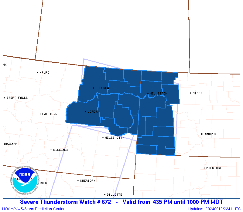
* Effective this Thursday afternoon and evening from 435 PM until
1000 PM MDT.
* Primary threats include...
Scattered damaging winds and isolated significant gusts to 85
mph likely
Scattered large hail events to 1.5 inches in diameter possible
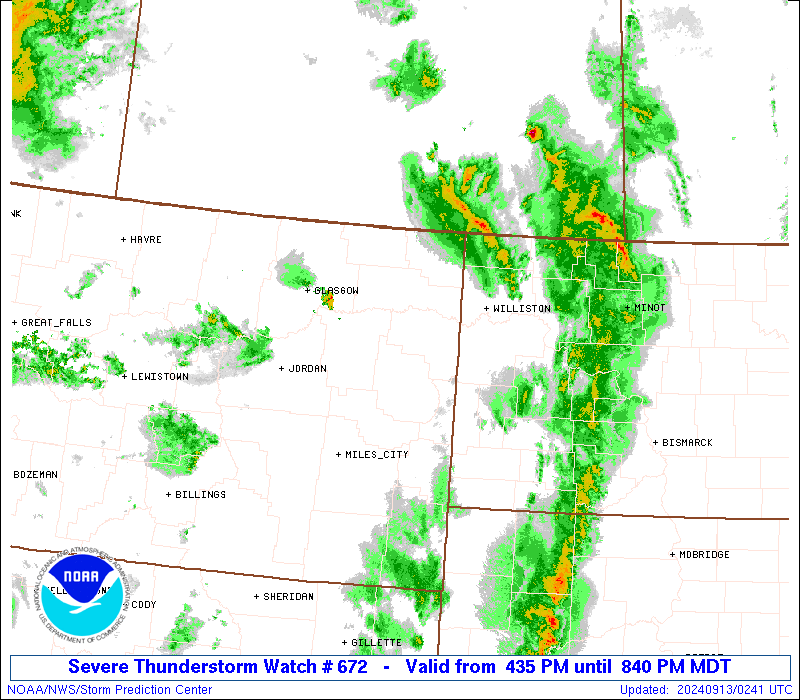
SUMMARY...Scattered thunderstorms will continue to develop and
intensify late this afternoon and evening and spread northeast into
the Watch area. The stronger thunderstorms, including a mix of
cells and linear clusters, will be potentially capable of a severe
threat. Severe gusts will probably be the primary severe hazard
(60-85 mph), but large hail may accompany the stronger thunderstorm
cores as well (1 to 1.5 inches in diameter).
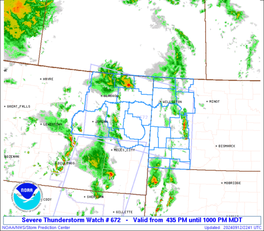
The severe thunderstorm watch area is approximately along and 85
statute miles north and south of a line from 35 miles west southwest
of Glasgow MT to 55 miles northeast of Dickinson ND. For a complete
depiction of the watch see the associated watch outline update
(WOUS64 KWNS WOU2).
PRECAUTIONARY/PREPAREDNESS ACTIONS...
REMEMBER...A Severe Thunderstorm Watch means conditions are
favorable for severe thunderstorms in and close to the watch area.
Persons in these areas should be on the lookout for threatening
weather conditions and listen for later statements and possible
warnings. Severe thunderstorms can and occasionally do produce
tornadoes.
&&
OTHER WATCH INFORMATION...CONTINUE...WW 670...WW 671...
AVIATION...A few severe thunderstorms with hail surface and aloft to
1.5 inches. Extreme turbulence and surface wind gusts to 75 knots. A
few cumulonimbi with maximum tops to 400. Mean storm motion vector
21050.
...Smith
   SEL2

   URGENT - IMMEDIATE BROADCAST REQUESTED
   Severe Thunderstorm Watch Number 672
   NWS Storm Prediction Center Norman OK
   435 PM MDT Thu Sep 12 2024

   The NWS Storm Prediction Center has issued a

   * Severe Thunderstorm Watch for portions of
     Northeastern and Eastern Montana
     Western North Dakota

   * Effective this Thursday afternoon and evening from 435 PM until
     1000 PM MDT.

   * Primary threats include...
     Scattered damaging winds and isolated significant gusts to 85
       mph likely
     Scattered large hail events to 1.5 inches in diameter possible

   SUMMARY...Scattered thunderstorms will continue to develop and
   intensify late this afternoon and evening and spread northeast into
   the Watch area.  The stronger thunderstorms, including a mix of
   cells and linear clusters, will be potentially capable of a severe
   threat.  Severe gusts will probably be the primary severe hazard
   (60-85 mph), but large hail may accompany the stronger thunderstorm
   cores as well (1 to 1.5 inches in diameter).

   The severe thunderstorm watch area is approximately along and 85
   statute miles north and south of a line from 35 miles west southwest
   of Glasgow MT to 55 miles northeast of Dickinson ND. For a complete
   depiction of the watch see the associated watch outline update
   (WOUS64 KWNS WOU2).

   PRECAUTIONARY/PREPAREDNESS ACTIONS...

   REMEMBER...A Severe Thunderstorm Watch means conditions are
   favorable for severe thunderstorms in and close to the watch area.
   Persons in these areas should be on the lookout for threatening
   weather conditions and listen for later statements and possible
   warnings. Severe thunderstorms can and occasionally do produce
   tornadoes.

   &&

   OTHER WATCH INFORMATION...CONTINUE...WW 670...WW 671...

   AVIATION...A few severe thunderstorms with hail surface and aloft to
   1.5 inches. Extreme turbulence and surface wind gusts to 75 knots. A
   few cumulonimbi with maximum tops to 400. Mean storm motion vector
   21050.

   ...Smith
 Note:
The Aviation Watch (SAW) product is an approximation to the watch area.
The actual watch is depicted by the shaded areas.
Note:
The Aviation Watch (SAW) product is an approximation to the watch area.
The actual watch is depicted by the shaded areas.
   SAW2
   WW 672 SEVERE TSTM MT ND 122235Z - 130400Z
   AXIS..85 STATUTE MILES NORTH AND SOUTH OF LINE..
   35WSW GGW/GLASGOW MT/ - 55NE DIK/DICKINSON ND/
   ..AVIATION COORDS.. 75NM N/S /30WSW GGW - 44NE DIK/
   HAIL SURFACE AND ALOFT..1.5 INCHES. WIND GUSTS..75 KNOTS.
   MAX TOPS TO 400. MEAN STORM MOTION VECTOR 21050.

   LAT...LON 49250732 48590197 46130197 46790732

   THIS IS AN APPROXIMATION TO THE WATCH AREA.  FOR A
   COMPLETE DEPICTION OF THE WATCH SEE WOUS64 KWNS
   FOR WOU2.
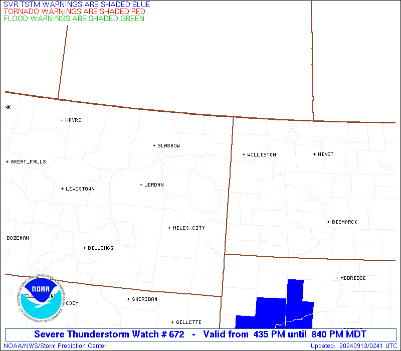
Watch 672 Status Report Messages:
STATUS REPORT #2 ON WW 672

VALID 130145Z - 130240Z

SEVERE WEATHER THREAT CONTINUES RIGHT OF A LINE FROM 20 W Y22 TO
40 WSW N60 TO 35 NNW SDY TO 75 SW GGW.

..WEINMAN..09/13/24

ATTN...WFO...GGW...BIS...

&&

STATUS REPORT FOR WS 672

SEVERE WEATHER THREAT CONTINUES FOR THE FOLLOWING AREAS

MTC019-085-091-105-130240-

MT
.    MONTANA COUNTIES INCLUDED ARE

DANIELS 	     ROOSEVELT		 SHERIDAN
VALLEY
$$


NDC001-013-023-041-061-105-130240-

ND
.    NORTH DAKOTA COUNTIES INCLUDED ARE

ADAMS		     BURKE		 DIVIDE
HETTINGER	     MOUNTRAIL		 WILLIAMS
$$


THE WATCH STATUS MESSAGE IS FOR GUIDANCE PURPOSES ONLY.  PLEASE
REFER TO WATCH COUNTY NOTIFICATION STATEMENTS FOR OFFICIAL
INFORMATION ON COUNTIES...INDEPENDENT CITIES AND MARINE ZONES
CLEARED FROM SEVERE THUNDERSTORM AND TORNADO WATCHES.
$$

STATUS REPORT #1 ON WW 672

VALID 130055Z - 130140Z

SEVERE WEATHER THREAT CONTINUES RIGHT OF A LINE FROM 25 W Y22 TO
10 ESE DIK TO 40 WNW GDV TO 35 W MLS.

..WEINMAN..09/13/24

ATTN...WFO...GGW...BIS...

&&

STATUS REPORT FOR WS 672

SEVERE WEATHER THREAT CONTINUES FOR THE FOLLOWING AREAS

MTC019-021-033-055-083-085-091-105-109-130140-

MT
.    MONTANA COUNTIES INCLUDED ARE

DANIELS 	     DAWSON		 GARFIELD
MCCONE		     RICHLAND		 ROOSEVELT
SHERIDAN	     VALLEY		 WIBAUX
$$


NDC001-007-013-023-025-033-041-053-061-089-105-130140-

ND
.    NORTH DAKOTA COUNTIES INCLUDED ARE

ADAMS		     BILLINGS		 BURKE
DIVIDE		     DUNN		 GOLDEN VALLEY
HETTINGER	     MCKENZIE		 MOUNTRAIL
STARK		     WILLIAMS
$$


THE WATCH STATUS MESSAGE IS FOR GUIDANCE PURPOSES ONLY.  PLEASE
REFER TO WATCH COUNTY NOTIFICATION STATEMENTS FOR OFFICIAL
INFORMATION ON COUNTIES...INDEPENDENT CITIES AND MARINE ZONES
CLEARED FROM SEVERE THUNDERSTORM AND TORNADO WATCHES.
$$
Note:
Click for Complete Product Text.
Tornadoes
Probability of 2 or more tornadoes
|
Low (10%)
|
Probability of 1 or more strong (EF2-EF5) tornadoes
|
Low (<2%)
|
Wind
Probability of 10 or more severe wind events
|
Mod (60%)
|
Probability of 1 or more wind events > 65 knots
|
Mod (60%)
|
Hail
Probability of 10 or more severe hail events
|
Mod (40%)
|
Probability of 1 or more hailstones > 2 inches
|
Low (20%)
|
Combined Severe Hail/Wind
Probability of 6 or more combined severe hail/wind events
|
High (90%)
|
For each watch, probabilities for particular events inside the watch
(listed above in each table) are determined by the issuing forecaster.
The "Low" category contains probability values ranging from less than 2%
to 20% (EF2-EF5 tornadoes), less than 5% to 20% (all other probabilities),
"Moderate" from 30% to 60%, and "High" from 70% to greater than 95%.
High values are bolded and lighter in color to provide awareness of
an increased threat for a particular event.


 @NWSSPC