 Note:
The expiration time in the watch graphic is amended if the watch is
replaced, cancelled or extended.
Note:
Note:
The expiration time in the watch graphic is amended if the watch is
replaced, cancelled or extended.
Note: Click for
Watch Status Reports.
SEL7
URGENT - IMMEDIATE BROADCAST REQUESTED
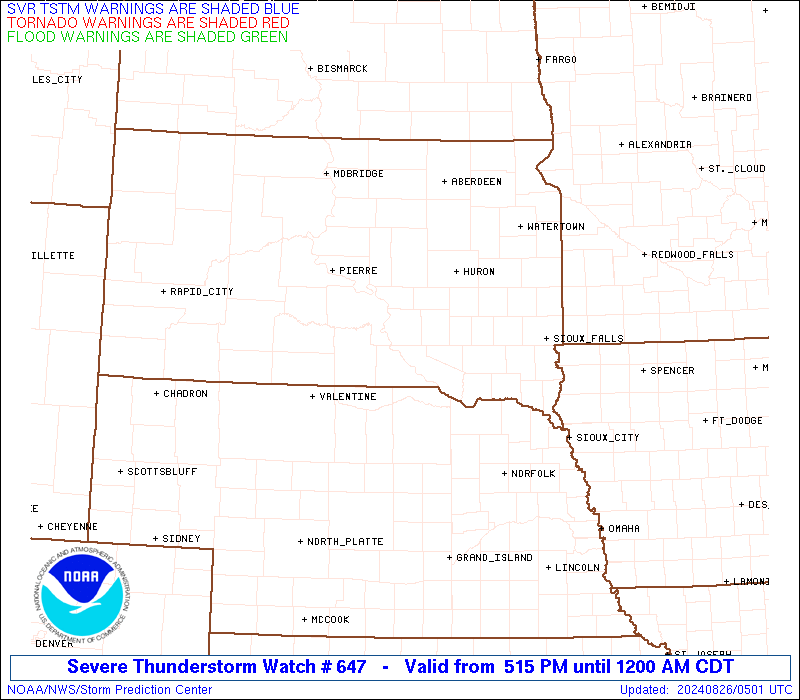
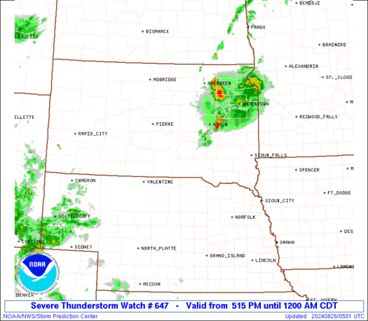
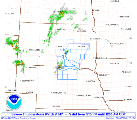
Severe Thunderstorm Watch Number 647
NWS Storm Prediction Center Norman OK
515 PM CDT Sun Aug 25 2024
The NWS Storm Prediction Center has issued a
* Severe Thunderstorm Watch for portions of
North-central Nebraska
Southeast and East-central South Dakota
* Effective this Sunday afternoon from 515 PM until Midnight CDT.
* Primary threats include...
Scattered damaging winds and isolated significant gusts to 75
mph possible
Scattered large hail and isolated very large hail events to 2
inches in diameter possible
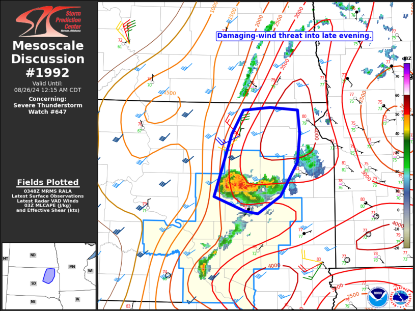
SUMMARY...Thunderstorms should intensify this evening while posing a
threat for large hail around 1-2 inches in diameter, along with
severe/damaging winds up to 65-75 mph. This threat should continue
through much of the evening as this activity spreads
east-northeastward.
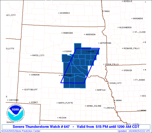
The severe thunderstorm watch area is approximately along and 50
statute miles east and west of a line from 15 miles north northeast
of Huron SD to 30 miles east southeast of Ainsworth NE. For a
complete depiction of the watch see the associated watch outline
update (WOUS64 KWNS WOU7).
PRECAUTIONARY/PREPAREDNESS ACTIONS...
REMEMBER...A Severe Thunderstorm Watch means conditions are
favorable for severe thunderstorms in and close to the watch area.
Persons in these areas should be on the lookout for threatening
weather conditions and listen for later statements and possible
warnings. Severe thunderstorms can and occasionally do produce
tornadoes.
&&
OTHER WATCH INFORMATION...CONTINUE...WW 646...
AVIATION...A few severe thunderstorms with hail surface and aloft to
2 inches. Extreme turbulence and surface wind gusts to 65 knots. A
few cumulonimbi with maximum tops to 500. Mean storm motion vector
26025.
...Gleason
   SEL7

   URGENT - IMMEDIATE BROADCAST REQUESTED
   Severe Thunderstorm Watch Number 647
   NWS Storm Prediction Center Norman OK
   515 PM CDT Sun Aug 25 2024

   The NWS Storm Prediction Center has issued a

   * Severe Thunderstorm Watch for portions of
     North-central Nebraska
     Southeast and East-central South Dakota

   * Effective this Sunday afternoon from 515 PM until Midnight CDT.

   * Primary threats include...
     Scattered damaging winds and isolated significant gusts to 75
       mph possible
     Scattered large hail and isolated very large hail events to 2
       inches in diameter possible

   SUMMARY...Thunderstorms should intensify this evening while posing a
   threat for large hail around 1-2 inches in diameter, along with
   severe/damaging winds up to 65-75 mph. This threat should continue
   through much of the evening as this activity spreads
   east-northeastward.

   The severe thunderstorm watch area is approximately along and 50
   statute miles east and west of a line from 15 miles north northeast
   of Huron SD to 30 miles east southeast of Ainsworth NE. For a
   complete depiction of the watch see the associated watch outline
   update (WOUS64 KWNS WOU7).

   PRECAUTIONARY/PREPAREDNESS ACTIONS...

   REMEMBER...A Severe Thunderstorm Watch means conditions are
   favorable for severe thunderstorms in and close to the watch area.
   Persons in these areas should be on the lookout for threatening
   weather conditions and listen for later statements and possible
   warnings. Severe thunderstorms can and occasionally do produce
   tornadoes.

   &&

   OTHER WATCH INFORMATION...CONTINUE...WW 646...

   AVIATION...A few severe thunderstorms with hail surface and aloft to
   2 inches. Extreme turbulence and surface wind gusts to 65 knots. A
   few cumulonimbi with maximum tops to 500. Mean storm motion vector
   26025.

   ...Gleason
 Note:
The Aviation Watch (SAW) product is an approximation to the watch area.
The actual watch is depicted by the shaded areas.
Note:
The Aviation Watch (SAW) product is an approximation to the watch area.
The actual watch is depicted by the shaded areas.
   SAW7
   WW 647 SEVERE TSTM NE SD 252215Z - 260500Z
   AXIS..50 STATUTE MILES EAST AND WEST OF LINE..
   15NNE HON/HURON SD/ - 30ESE ANW/AINSWORTH NE/
   ..AVIATION COORDS.. 45NM E/W /52SSE ABR - 26ESE ANW/
   HAIL SURFACE AND ALOFT..2 INCHES. WIND GUSTS..65 KNOTS.
   MAX TOPS TO 500. MEAN STORM MOTION VECTOR 26025.

   LAT...LON 44589710 42419846 42410042 44589913

   THIS IS AN APPROXIMATION TO THE WATCH AREA.  FOR A
   COMPLETE DEPICTION OF THE WATCH SEE WOUS64 KWNS
   FOR WOU7.
Watch 647 Status Report Messages:
STATUS REPORT #3 ON WW 647

VALID 260245Z - 260340Z

SEVERE WEATHER THREAT CONTINUES RIGHT OF A LINE FROM 35 W YKN TO
25 N ANW TO 40 ENE PIR.

..DEAN..08/26/24

ATTN...WFO...LBF...FSD...ABR...UNR...

&&

STATUS REPORT FOR WS 647

SEVERE WEATHER THREAT CONTINUES FOR THE FOLLOWING AREAS

SDC003-005-015-017-023-025-035-043-053-059-061-073-077-085-097-
111-115-260340-

SD
.    SOUTH DAKOTA COUNTIES INCLUDED ARE

AURORA		     BEADLE		 BRULE
BUFFALO 	     CHARLES MIX	 CLARK
DAVISON 	     DOUGLAS		 GREGORY
HAND		     HANSON		 JERAULD
KINGSBURY	     LYMAN		 MINER
SANBORN 	     SPINK
$$


THE WATCH STATUS MESSAGE IS FOR GUIDANCE PURPOSES ONLY.  PLEASE
REFER TO WATCH COUNTY NOTIFICATION STATEMENTS FOR OFFICIAL
INFORMATION ON COUNTIES...INDEPENDENT CITIES AND MARINE ZONES
CLEARED FROM SEVERE THUNDERSTORM AND TORNADO WATCHES.
$$

STATUS REPORT #2 ON WW 647

VALID 260010Z - 260140Z

THE SEVERE WEATHER THREAT CONTINUES ACROSS THE ENTIRE WATCH AREA.

..DEAN..08/26/24

ATTN...WFO...LBF...FSD...ABR...UNR...

&&

STATUS REPORT FOR WS 647

SEVERE WEATHER THREAT CONTINUES FOR THE FOLLOWING AREAS

NEC015-017-089-103-149-260140-

NE
.    NEBRASKA COUNTIES INCLUDED ARE

BOYD		     BROWN		 HOLT
KEYA PAHA	     ROCK
$$


SDC003-005-015-017-023-035-043-053-059-061-073-077-085-097-111-
123-260140-

SD
.    SOUTH DAKOTA COUNTIES INCLUDED ARE

AURORA		     BEADLE		 BRULE
BUFFALO 	     CHARLES MIX	 DAVISON
DOUGLAS 	     GREGORY		 HAND
HANSON		     JERAULD		 KINGSBURY
LYMAN		     MINER		 SANBORN
TRIPP
$$


THE WATCH STATUS MESSAGE IS FOR GUIDANCE PURPOSES ONLY.  PLEASE
REFER TO WATCH COUNTY NOTIFICATION STATEMENTS FOR OFFICIAL
INFORMATION ON COUNTIES...INDEPENDENT CITIES AND MARINE ZONES
CLEARED FROM SEVERE THUNDERSTORM AND TORNADO WATCHES.
$$

STATUS REPORT #1 ON WW 647

VALID 252320Z - 260040Z

THE SEVERE WEATHER THREAT CONTINUES ACROSS THE ENTIRE WATCH AREA.

..DEAN..08/25/24

ATTN...WFO...LBF...FSD...ABR...UNR...

&&

STATUS REPORT FOR WS 647

SEVERE WEATHER THREAT CONTINUES FOR THE FOLLOWING AREAS

NEC015-017-089-103-149-260040-

NE
.    NEBRASKA COUNTIES INCLUDED ARE

BOYD		     BROWN		 HOLT
KEYA PAHA	     ROCK
$$


SDC003-005-015-017-023-035-043-053-059-061-073-077-085-097-111-
123-260040-

SD
.    SOUTH DAKOTA COUNTIES INCLUDED ARE

AURORA		     BEADLE		 BRULE
BUFFALO 	     CHARLES MIX	 DAVISON
DOUGLAS 	     GREGORY		 HAND
HANSON		     JERAULD		 KINGSBURY
LYMAN		     MINER		 SANBORN
TRIPP
$$


THE WATCH STATUS MESSAGE IS FOR GUIDANCE PURPOSES ONLY.  PLEASE
REFER TO WATCH COUNTY NOTIFICATION STATEMENTS FOR OFFICIAL
INFORMATION ON COUNTIES...INDEPENDENT CITIES AND MARINE ZONES
CLEARED FROM SEVERE THUNDERSTORM AND TORNADO WATCHES.
$$
Note:
Click for Complete Product Text.
Tornadoes
Probability of 2 or more tornadoes
|
Low (10%)
|
Probability of 1 or more strong (EF2-EF5) tornadoes
|
Low (<2%)
|
Wind
Probability of 10 or more severe wind events
|
Mod (40%)
|
Probability of 1 or more wind events > 65 knots
|
Mod (30%)
|
Hail
Probability of 10 or more severe hail events
|
Mod (40%)
|
Probability of 1 or more hailstones > 2 inches
|
Mod (30%)
|
Combined Severe Hail/Wind
Probability of 6 or more combined severe hail/wind events
|
High (80%)
|
For each watch, probabilities for particular events inside the watch
(listed above in each table) are determined by the issuing forecaster.
The "Low" category contains probability values ranging from less than 2%
to 20% (EF2-EF5 tornadoes), less than 5% to 20% (all other probabilities),
"Moderate" from 30% to 60%, and "High" from 70% to greater than 95%.
High values are bolded and lighter in color to provide awareness of
an increased threat for a particular event.


 @NWSSPC