 Note:
The expiration time in the watch graphic is amended if the watch is
replaced, cancelled or extended.
Note:
Note:
The expiration time in the watch graphic is amended if the watch is
replaced, cancelled or extended.
Note: Click for
Watch Status Reports.
SEL8
URGENT - IMMEDIATE BROADCAST REQUESTED
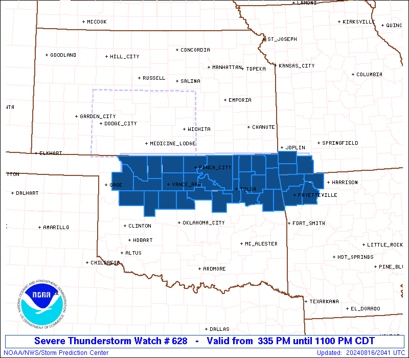
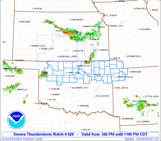
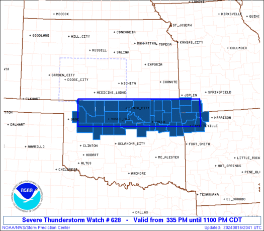
Severe Thunderstorm Watch Number 628
NWS Storm Prediction Center Norman OK
335 PM CDT Fri Aug 16 2024
The NWS Storm Prediction Center has issued a
* Severe Thunderstorm Watch for portions of
Northwest Arkansas
Extreme southwest Missouri
Northern Oklahoma
* Effective this Friday afternoon and evening from 335 PM until
1100 PM CDT.
* Primary threats include...
Scattered damaging winds likely with isolated significant gusts
to 75 mph possible
Scattered large hail likely with isolated very large hail events
to 2.5 inches in diameter possible
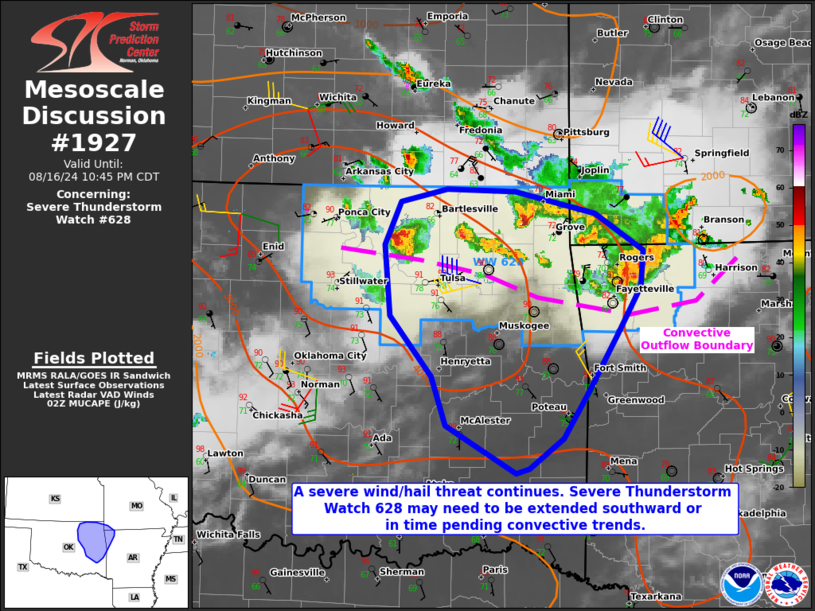
SUMMARY...Multiple areas of thunderstorm development are possible
along and south of the Kansas/Oklahoma border through late evening,
in a storm environment favoring organized clusters and supercells.
The more intense storms will be capable of producing very large hail
up to 2.5 inches in diameter, as well as severe outflow winds up to
75 mph.
The severe thunderstorm watch area is approximately along and 35
statute miles north and south of a line from 40 miles west southwest
of Alva OK to 30 miles south southeast of Monett MO. For a complete
depiction of the watch see the associated watch outline update
(WOUS64 KWNS WOU8).
PRECAUTIONARY/PREPAREDNESS ACTIONS...
REMEMBER...A Severe Thunderstorm Watch means conditions are
favorable for severe thunderstorms in and close to the watch area.
Persons in these areas should be on the lookout for threatening
weather conditions and listen for later statements and possible
warnings. Severe thunderstorms can and occasionally do produce
tornadoes.
&&
OTHER WATCH INFORMATION...CONTINUE...WW 627...
AVIATION...A few severe thunderstorms with hail surface and aloft to
2.5 inches. Extreme turbulence and surface wind gusts to 65 knots. A
few cumulonimbi with maximum tops to 600. Mean storm motion vector
30025.
...Thompson
   SEL8

   URGENT - IMMEDIATE BROADCAST REQUESTED
   Severe Thunderstorm Watch Number 628
   NWS Storm Prediction Center Norman OK
   335 PM CDT Fri Aug 16 2024

   The NWS Storm Prediction Center has issued a

   * Severe Thunderstorm Watch for portions of
     Northwest Arkansas
     Extreme southwest Missouri
     Northern Oklahoma

   * Effective this Friday afternoon and evening from 335 PM until
     1100 PM CDT.

   * Primary threats include...
     Scattered damaging winds likely with isolated significant gusts
       to 75 mph possible
     Scattered large hail likely with isolated very large hail events
       to 2.5 inches in diameter possible

   SUMMARY...Multiple areas of thunderstorm development are possible
   along and south of the Kansas/Oklahoma border through late evening,
   in a storm environment favoring organized clusters and supercells.
   The more intense storms will be capable of producing very large hail
   up to 2.5 inches in diameter, as well as severe outflow winds up to
   75 mph.

   The severe thunderstorm watch area is approximately along and 35
   statute miles north and south of a line from 40 miles west southwest
   of Alva OK to 30 miles south southeast of Monett MO. For a complete
   depiction of the watch see the associated watch outline update
   (WOUS64 KWNS WOU8).

   PRECAUTIONARY/PREPAREDNESS ACTIONS...

   REMEMBER...A Severe Thunderstorm Watch means conditions are
   favorable for severe thunderstorms in and close to the watch area.
   Persons in these areas should be on the lookout for threatening
   weather conditions and listen for later statements and possible
   warnings. Severe thunderstorms can and occasionally do produce
   tornadoes.

   &&

   OTHER WATCH INFORMATION...CONTINUE...WW 627...

   AVIATION...A few severe thunderstorms with hail surface and aloft to
   2.5 inches. Extreme turbulence and surface wind gusts to 65 knots. A
   few cumulonimbi with maximum tops to 600. Mean storm motion vector
   30025.

   ...Thompson
 Note:
The Aviation Watch (SAW) product is an approximation to the watch area.
The actual watch is depicted by the shaded areas.
Note:
The Aviation Watch (SAW) product is an approximation to the watch area.
The actual watch is depicted by the shaded areas.
   SAW8
   WW 628 SEVERE TSTM AR MO OK 162035Z - 170400Z
   AXIS..35 STATUTE MILES NORTH AND SOUTH OF LINE..
   40WSW AVK/ALVA OK/ - 30SSE UMN/MONETT MO/
   ..AVIATION COORDS.. 30NM N/S /29ENE MMB - 25NE RZC/
   HAIL SURFACE AND ALOFT..2.5 INCHES. WIND GUSTS..65 KNOTS.
   MAX TOPS TO 600. MEAN STORM MOTION VECTOR 30025.

   LAT...LON 37059934 36999369 35979369 36049934

   THIS IS AN APPROXIMATION TO THE WATCH AREA.  FOR A
   COMPLETE DEPICTION OF THE WATCH SEE WOUS64 KWNS
   FOR WOU8.
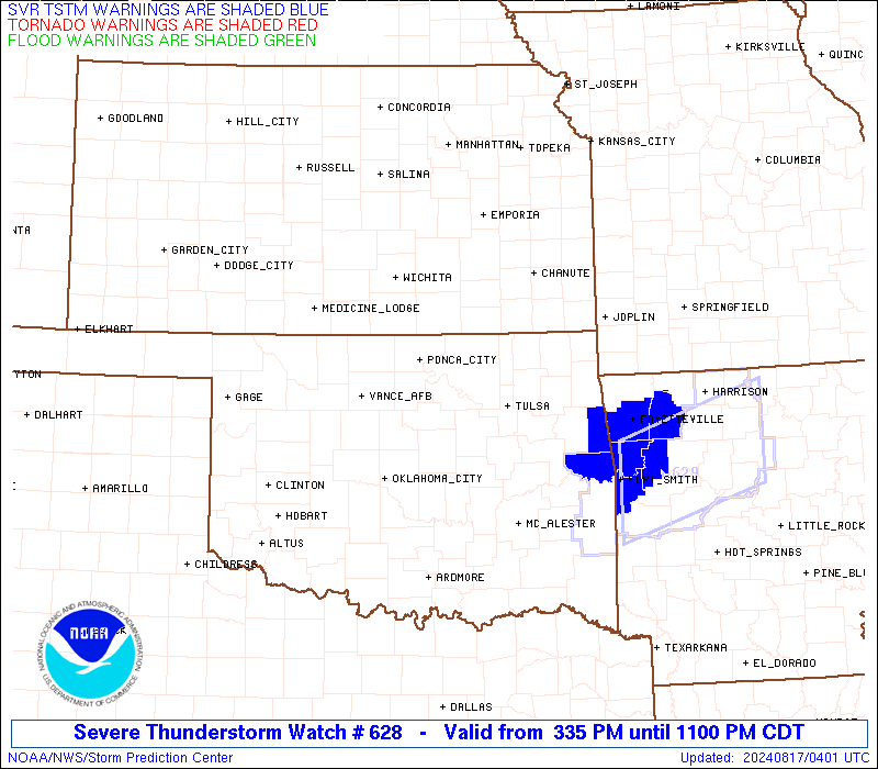
Watch 628 Status Report Messages:
STATUS REPORT #1 ON WW 628

VALID 170205Z - 170340Z

SEVERE WEATHER THREAT CONTINUES RIGHT OF A LINE FROM 35 SE END TO
20 NE END TO 35 SSE ICT.

..SQUITIERI..08/17/24

ATTN...WFO...TSA...SGF...OUN...

&&

STATUS REPORT FOR WS 628

SEVERE WEATHER THREAT CONTINUES FOR THE FOLLOWING AREAS

ARC007-015-087-143-170340-

AR
.    ARKANSAS COUNTIES INCLUDED ARE

BENTON		     CARROLL		 MADISON
WASHINGTON
$$


MOC009-119-145-170340-

MO
.    MISSOURI COUNTIES INCLUDED ARE

BARRY		     MCDONALD		 NEWTON
$$


OKC001-021-035-037-041-071-097-103-105-113-115-117-119-131-143-
145-147-170340-

OK
.    OKLAHOMA COUNTIES INCLUDED ARE

ADAIR		     CHEROKEE		 CRAIG
CREEK		     DELAWARE		 KAY
MAYES		     NOBLE		 NOWATA
OSAGE		     OTTAWA		 PAWNEE
PAYNE		     ROGERS		 TULSA
WAGONER 	     WASHINGTON
$$


THE WATCH STATUS MESSAGE IS FOR GUIDANCE PURPOSES ONLY.  PLEASE
REFER TO WATCH COUNTY NOTIFICATION STATEMENTS FOR OFFICIAL
INFORMATION ON COUNTIES...INDEPENDENT CITIES AND MARINE ZONES
CLEARED FROM SEVERE THUNDERSTORM AND TORNADO WATCHES.
$$
Note:
Click for Complete Product Text.
Tornadoes
Probability of 2 or more tornadoes
|
Low (10%)
|
Probability of 1 or more strong (EF2-EF5) tornadoes
|
Low (<2%)
|
Wind
Probability of 10 or more severe wind events
|
Mod (60%)
|
Probability of 1 or more wind events > 65 knots
|
Mod (40%)
|
Hail
Probability of 10 or more severe hail events
|
Mod (60%)
|
Probability of 1 or more hailstones > 2 inches
|
Mod (50%)
|
Combined Severe Hail/Wind
Probability of 6 or more combined severe hail/wind events
|
High (90%)
|
For each watch, probabilities for particular events inside the watch
(listed above in each table) are determined by the issuing forecaster.
The "Low" category contains probability values ranging from less than 2%
to 20% (EF2-EF5 tornadoes), less than 5% to 20% (all other probabilities),
"Moderate" from 30% to 60%, and "High" from 70% to greater than 95%.
High values are bolded and lighter in color to provide awareness of
an increased threat for a particular event.


 @NWSSPC