|
| Mesoscale Discussion 1927 |
|
< Previous MD Next MD >
|
|
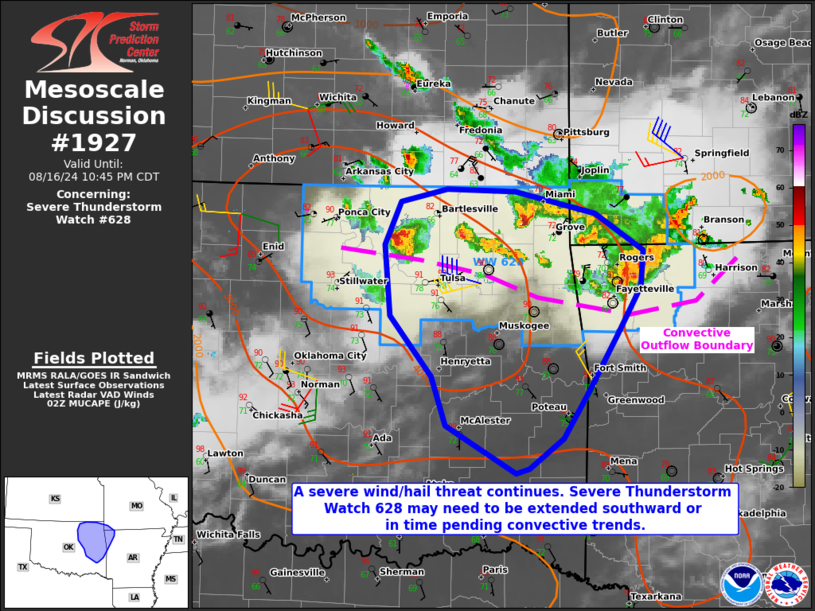
   Mesoscale Discussion 1927
   NWS Storm Prediction Center Norman OK
   0921 PM CDT Fri Aug 16 2024

   Areas affected...portions of eastern Oklahoma into far northwestern
   Arkansas

   Concerning...Severe Thunderstorm Watch 628...

   Valid 170221Z - 170345Z

   The severe weather threat for Severe Thunderstorm Watch 628
   continues.

   SUMMARY...The severe threat continues across Severe Thunderstorm
   Watch 628, with a severe wind/hail threat persisting. Upscale growth
   into a more organized cluster of storms is possible, and local
   spatial/temporal extensions of the watch may be needed should this
   upscale growth occur.

   DISCUSSION...Multicells and supercells persist across northeast OK
   with a history of severe wind and hail. These storms are displaced
   slightly on the cool side of a convective outflow boundary that
   continues to surge southward in tandem with a leading convective
   complex in northwestern AR. MLCINH will increase through the evening
   given nocturnal cooling. However, the rate of MLCINH increase will
   be gradual given abundant low-level moisture, which is also
   contributing to 4000 J/kg MUCAPE. Given adequate deep-layer shear
   also in place, at least a short-term severe threat should persist.
   However, should storms catch up to and anchor along the leading
   outflow boundary while also merging cold pools, a more organized MCS
   could materialize with a persistent severe gust threat, and an
   occasional instance of large hail also possible. Should an MCS
   develop, temporal and/or spatial southward extensions of Severe
   Thunderstorm Watch 628 may be needed.

   ..Squitieri.. 08/17/2024

   ...Please see www.spc.noaa.gov for graphic product...

   ATTN...WFO...SGF...TSA...OUN...

   LAT...LON   35369608 35889652 36499658 36869641 36989592 36959520
               36779434 36449384 36149386 35739411 35259441 34839469
               34579504 34549519 34959592 35369608
|
|
Top/All Mesoscale Discussions/Forecast Products/Home
|
|


 @NWSSPC