 Note:
The expiration time in the watch graphic is amended if the watch is
replaced, cancelled or extended.
Note:
Note:
The expiration time in the watch graphic is amended if the watch is
replaced, cancelled or extended.
Note: Click for
Watch Status Reports.
SEL3
URGENT - IMMEDIATE BROADCAST REQUESTED
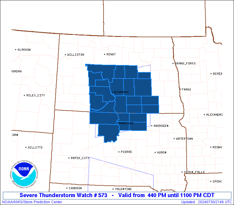
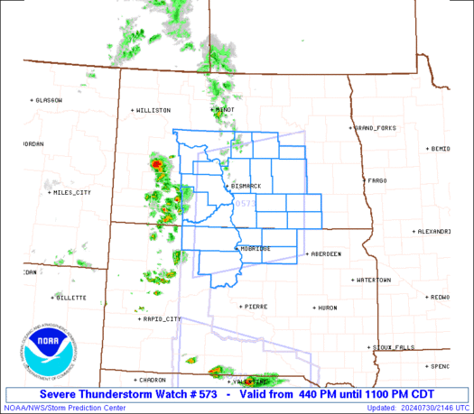
Severe Thunderstorm Watch Number 573
NWS Storm Prediction Center Norman OK
440 PM CDT Tue Jul 30 2024
The NWS Storm Prediction Center has issued a
* Severe Thunderstorm Watch for portions of
Central North Dakota
North Central South Dakota
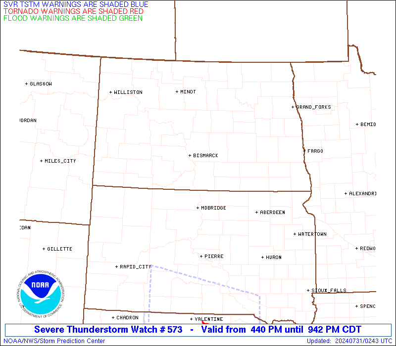
* Effective this Tuesday afternoon and evening from 440 PM until
1100 PM CDT.
* Primary threats include...
Scattered large hail likely with isolated very large hail events
to 2 inches in diameter possible
Scattered damaging wind gusts to 70 mph likely
SUMMARY...Thunderstorms are intensifying over western ND/SD. These
storms will track eastward this afternoon and evening, posing a risk
of large hail and locally damaging winds.
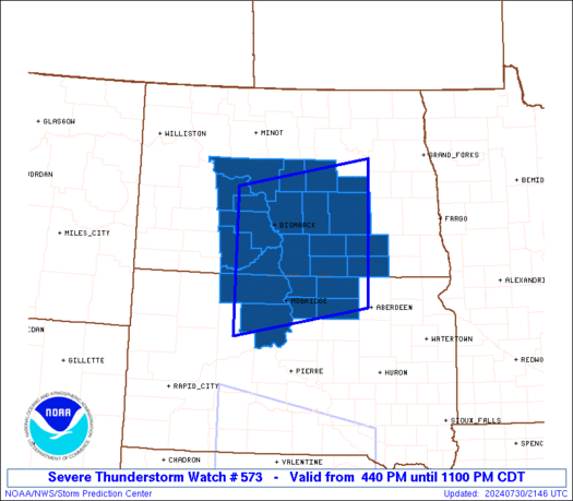
The severe thunderstorm watch area is approximately along and 85
statute miles north and south of a line from 60 miles southwest of
Bismarck ND to 20 miles south southeast of Jamestown ND. For a
complete depiction of the watch see the associated watch outline
update (WOUS64 KWNS WOU3).
PRECAUTIONARY/PREPAREDNESS ACTIONS...
REMEMBER...A Severe Thunderstorm Watch means conditions are
favorable for severe thunderstorms in and close to the watch area.
Persons in these areas should be on the lookout for threatening
weather conditions and listen for later statements and possible
warnings. Severe thunderstorms can and occasionally do produce
tornadoes.
&&
OTHER WATCH INFORMATION...CONTINUE...WW 570...WW 571...WW 572...
AVIATION...A few severe thunderstorms with hail surface and aloft to
2 inches. Extreme turbulence and surface wind gusts to 60 knots. A
few cumulonimbi with maximum tops to 500. Mean storm motion vector
27025.
...Hart
   SEL3

   URGENT - IMMEDIATE BROADCAST REQUESTED
   Severe Thunderstorm Watch Number 573
   NWS Storm Prediction Center Norman OK
   440 PM CDT Tue Jul 30 2024

   The NWS Storm Prediction Center has issued a

   * Severe Thunderstorm Watch for portions of
     Central North Dakota
     North Central South Dakota

   * Effective this Tuesday afternoon and evening from 440 PM until
     1100 PM CDT.

   * Primary threats include...
     Scattered large hail likely with isolated very large hail events
       to 2 inches in diameter possible
     Scattered damaging wind gusts to 70 mph likely

   SUMMARY...Thunderstorms are intensifying over western ND/SD.  These
   storms will track eastward this afternoon and evening, posing a risk
   of large hail and locally damaging winds.

   The severe thunderstorm watch area is approximately along and 85
   statute miles north and south of a line from 60 miles southwest of
   Bismarck ND to 20 miles south southeast of Jamestown ND. For a
   complete depiction of the watch see the associated watch outline
   update (WOUS64 KWNS WOU3).

   PRECAUTIONARY/PREPAREDNESS ACTIONS...

   REMEMBER...A Severe Thunderstorm Watch means conditions are
   favorable for severe thunderstorms in and close to the watch area.
   Persons in these areas should be on the lookout for threatening
   weather conditions and listen for later statements and possible
   warnings. Severe thunderstorms can and occasionally do produce
   tornadoes.

   &&

   OTHER WATCH INFORMATION...CONTINUE...WW 570...WW 571...WW 572...

   AVIATION...A few severe thunderstorms with hail surface and aloft to
   2 inches. Extreme turbulence and surface wind gusts to 60 knots. A
   few cumulonimbi with maximum tops to 500. Mean storm motion vector
   27025.

   ...Hart
 Note:
The Aviation Watch (SAW) product is an approximation to the watch area.
The actual watch is depicted by the shaded areas.
Note:
The Aviation Watch (SAW) product is an approximation to the watch area.
The actual watch is depicted by the shaded areas.
SAW3
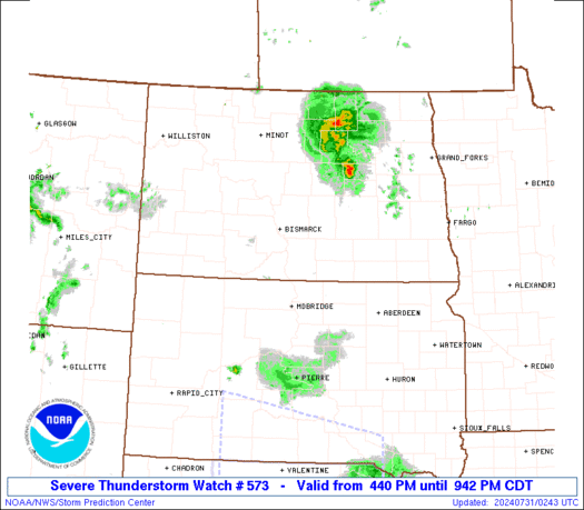
WW 573 SEVERE TSTM ND SD 302140Z - 310400Z
AXIS..85 STATUTE MILES NORTH AND SOUTH OF LINE..
60SW BIS/BISMARCK ND/ - 20SSE JMS/JAMESTOWN ND/
..AVIATION COORDS.. 75NM N/S /54SW BIS - 69W FAR/
HAIL SURFACE AND ALOFT..2 INCHES. WIND GUSTS..60 KNOTS.
MAX TOPS TO 500. MEAN STORM MOTION VECTOR 27025.
LAT...LON 47390164 47899852 45439852 44930164
THIS IS AN APPROXIMATION TO THE WATCH AREA. FOR A
COMPLETE DEPICTION OF THE WATCH SEE WOUS64 KWNS
FOR WOU3.
Watch 573 Status Report Messages:
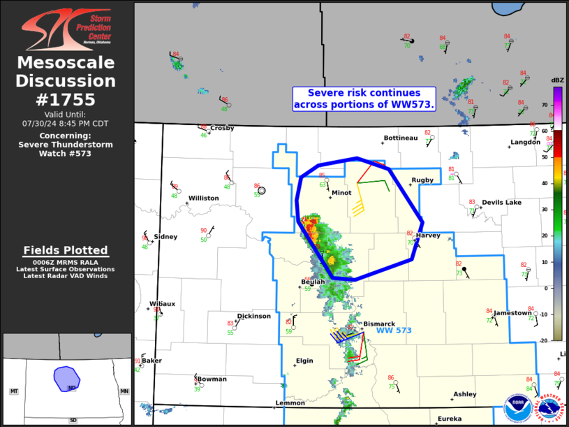
STATUS REPORT #3 ON WW 573

VALID 310145Z - 310240Z

SEVERE WEATHER THREAT CONTINUES RIGHT OF A LINE FROM 40 NE JMS TO
40 SE MOT.

FOR ADDITIONAL INFORMATION SEE MESOSCALE DISCUSSION 1755

..WEINMAN..07/31/24

ATTN...WFO...BIS...ABR...

&&

STATUS REPORT FOR WS 573

SEVERE WEATHER THREAT CONTINUES FOR THE FOLLOWING AREAS

NDC049-069-310240-

ND
.    NORTH DAKOTA COUNTIES INCLUDED ARE

MCHENRY 	     PIERCE
$$


THE WATCH STATUS MESSAGE IS FOR GUIDANCE PURPOSES ONLY.  PLEASE
REFER TO WATCH COUNTY NOTIFICATION STATEMENTS FOR OFFICIAL
INFORMATION ON COUNTIES...INDEPENDENT CITIES AND MARINE ZONES
CLEARED FROM SEVERE THUNDERSTORM AND TORNADO WATCHES.
$$

STATUS REPORT #2 ON WW 573

VALID 310040Z - 310140Z

SEVERE WEATHER THREAT CONTINUES RIGHT OF A LINE FROM 50 NW PIR TO
5 WSW BIS TO 30 SW MOT.

FOR ADDITIONAL INFORMATION SEE MESOSCALE DISCUSSION 1755

..WEINMAN..07/31/24

ATTN...WFO...BIS...ABR...

&&

STATUS REPORT FOR WS 573

SEVERE WEATHER THREAT CONTINUES FOR THE FOLLOWING AREAS

NDC015-021-029-031-043-045-047-049-051-055-069-083-085-093-101-
103-310140-

ND
.    NORTH DAKOTA COUNTIES INCLUDED ARE

BURLEIGH	     DICKEY		 EMMONS
FOSTER		     KIDDER		 LAMOURE
LOGAN		     MCHENRY		 MCINTOSH
MCLEAN		     PIERCE		 SHERIDAN
SIOUX		     STUTSMAN		 WARD
WELLS
$$


SDC021-031-041-045-089-129-310140-

SD
.    SOUTH DAKOTA COUNTIES INCLUDED ARE

CAMPBELL	     CORSON		 DEWEY
EDMUNDS 	     MCPHERSON		 WALWORTH
$$


THE WATCH STATUS MESSAGE IS FOR GUIDANCE PURPOSES ONLY.  PLEASE
REFER TO WATCH COUNTY NOTIFICATION STATEMENTS FOR OFFICIAL
INFORMATION ON COUNTIES...INDEPENDENT CITIES AND MARINE ZONES
CLEARED FROM SEVERE THUNDERSTORM AND TORNADO WATCHES.
$$

STATUS REPORT #1 ON WW 573

VALID 302340Z - 310040Z

THE SEVERE WEATHER THREAT CONTINUES ACROSS THE ENTIRE WATCH AREA.

..WEINMAN..07/30/24

ATTN...WFO...BIS...ABR...

&&

STATUS REPORT FOR WS 573

SEVERE WEATHER THREAT CONTINUES FOR THE FOLLOWING AREAS

NDC015-021-029-031-037-043-045-047-051-055-057-059-065-083-085-
093-103-310040-

ND
.    NORTH DAKOTA COUNTIES INCLUDED ARE

BURLEIGH	     DICKEY		 EMMONS
FOSTER		     GRANT		 KIDDER
LAMOURE 	     LOGAN		 MCINTOSH
MCLEAN		     MERCER		 MORTON
OLIVER		     SHERIDAN		 SIOUX
STUTSMAN	     WELLS
$$


SDC021-031-041-045-089-129-310040-

SD
.    SOUTH DAKOTA COUNTIES INCLUDED ARE

CAMPBELL	     CORSON		 DEWEY
EDMUNDS 	     MCPHERSON		 WALWORTH
$$


THE WATCH STATUS MESSAGE IS FOR GUIDANCE PURPOSES ONLY.  PLEASE
REFER TO WATCH COUNTY NOTIFICATION STATEMENTS FOR OFFICIAL
INFORMATION ON COUNTIES...INDEPENDENT CITIES AND MARINE ZONES
CLEARED FROM SEVERE THUNDERSTORM AND TORNADO WATCHES.
$$
Note:
Click for Complete Product Text.
Tornadoes
Probability of 2 or more tornadoes
|
Low (10%)
|
Probability of 1 or more strong (EF2-EF5) tornadoes
|
Low (<2%)
|
Wind
Probability of 10 or more severe wind events
|
Mod (60%)
|
Probability of 1 or more wind events > 65 knots
|
Low (20%)
|
Hail
Probability of 10 or more severe hail events
|
Mod (60%)
|
Probability of 1 or more hailstones > 2 inches
|
Mod (30%)
|
Combined Severe Hail/Wind
Probability of 6 or more combined severe hail/wind events
|
High (>95%)
|
For each watch, probabilities for particular events inside the watch
(listed above in each table) are determined by the issuing forecaster.
The "Low" category contains probability values ranging from less than 2%
to 20% (EF2-EF5 tornadoes), less than 5% to 20% (all other probabilities),
"Moderate" from 30% to 60%, and "High" from 70% to greater than 95%.
High values are bolded and lighter in color to provide awareness of
an increased threat for a particular event.


 @NWSSPC