Note:
The expiration time in the watch graphic is amended if the watch is
replaced, cancelled or extended.
Note:
Note:
The expiration time in the watch graphic is amended if the watch is
replaced, cancelled or extended.
Note: Click for
Watch Status Reports.
SEL9
URGENT - IMMEDIATE BROADCAST REQUESTED
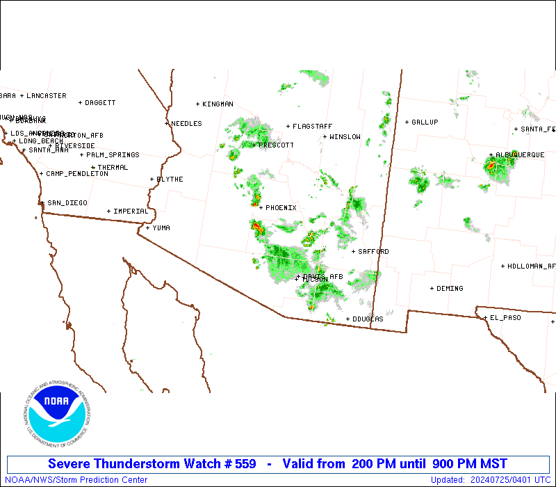
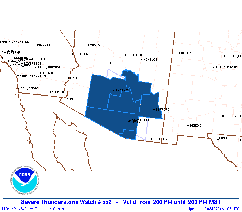
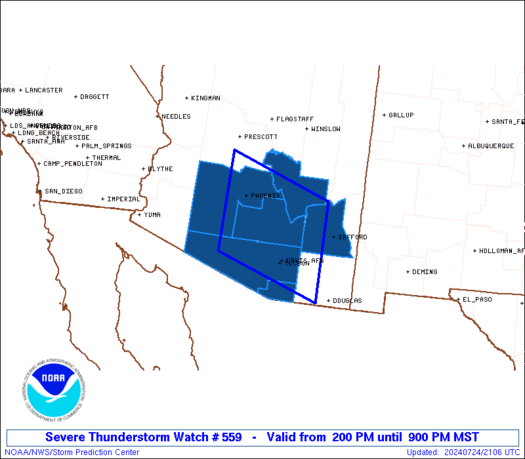
Severe Thunderstorm Watch Number 559
NWS Storm Prediction Center Norman OK
200 PM MST Wed Jul 24 2024
The NWS Storm Prediction Center has issued a
* Severe Thunderstorm Watch for portions of
Central and southern Arizona
* Effective this Wednesday afternoon and evening from 200 PM
until 900 PM MST.
* Primary threats include...
Isolated damaging wind gusts to 70 mph possible
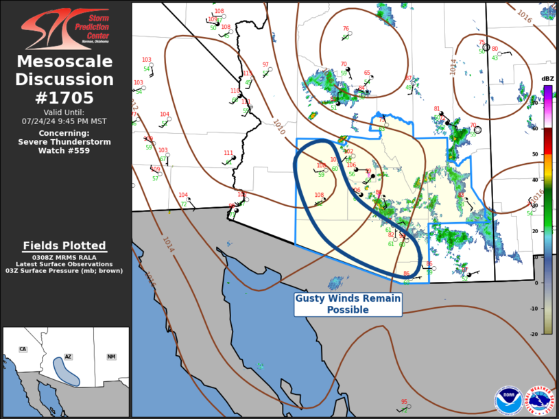
SUMMARY...Clusters of thunderstorms will form over the Rim and
spread southwestward to the lower deserts through late evening. The
storm environment will favor strong downdrafts capable of producing
occasional damaging/severe outflow gusts of 60-70 mph.
The severe thunderstorm watch area is approximately along and 75
statute miles north and south of a line from 30 miles west southwest
of Phoenix AZ to 65 miles east northeast of Tucson AZ. For a
complete depiction of the watch see the associated watch outline
update (WOUS64 KWNS WOU9).
PRECAUTIONARY/PREPAREDNESS ACTIONS...
REMEMBER...A Severe Thunderstorm Watch means conditions are
favorable for severe thunderstorms in and close to the watch area.
Persons in these areas should be on the lookout for threatening
weather conditions and listen for later statements and possible
warnings. Severe thunderstorms can and occasionally do produce
tornadoes.
&&
AVIATION...A few severe thunderstorms with hail surface and aloft to
0.5 inches. Extreme turbulence and surface wind gusts to 60 knots. A
few cumulonimbi with maximum tops to 550. Mean storm motion vector
03020.
...Thompson
 Note:
The Aviation Watch (SAW) product is an approximation to the watch area.
The actual watch is depicted by the shaded areas.
Note:
The Aviation Watch (SAW) product is an approximation to the watch area.
The actual watch is depicted by the shaded areas.
   SAW9
   WW 559 SEVERE TSTM AZ 242100Z - 250400Z
   AXIS..75 STATUTE MILES NORTH AND SOUTH OF LINE..
   30WSW PHX/PHOENIX AZ/ - 65ENE TUS/TUCSON AZ/
   ..AVIATION COORDS.. 65NM N/S /26WSW PHX - 35WNW SSO/
   HAIL SURFACE AND ALOFT..0.5 INCH. WIND GUSTS..60 KNOTS.
   MAX TOPS TO 550. MEAN STORM MOTION VECTOR 03020.

   LAT...LON 34341250 33550992 31380992 32181250

   THIS IS AN APPROXIMATION TO THE WATCH AREA.  FOR A
   COMPLETE DEPICTION OF THE WATCH SEE WOUS64 KWNS
   FOR WOU9.
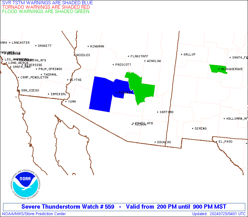
Watch 559 Status Report Messages:
STATUS REPORT #2 ON WW 559

VALID 250040Z - 250140Z

THE SEVERE WEATHER THREAT CONTINUES ACROSS THE ENTIRE WATCH AREA.

..HALBERT..07/25/24

ATTN...WFO...PSR...TWC...

&&

STATUS REPORT FOR WS 559

SEVERE WEATHER THREAT CONTINUES FOR THE FOLLOWING AREAS

AZC007-009-013-019-021-023-250140-

AZ
.    ARIZONA COUNTIES INCLUDED ARE

GILA		     GRAHAM		 MARICOPA
PIMA		     PINAL		 SANTA CRUZ
$$


THE WATCH STATUS MESSAGE IS FOR GUIDANCE PURPOSES ONLY.  PLEASE
REFER TO WATCH COUNTY NOTIFICATION STATEMENTS FOR OFFICIAL
INFORMATION ON COUNTIES...INDEPENDENT CITIES AND MARINE ZONES
CLEARED FROM SEVERE THUNDERSTORM AND TORNADO WATCHES.
$$

STATUS REPORT #1 ON WW 559

VALID 242250Z - 242340Z

THE SEVERE WEATHER THREAT CONTINUES ACROSS THE ENTIRE WATCH AREA.

FOR ADDITIONAL INFORMATION SEE MESOSCALE DISCUSSION 1704

..HALBERT..07/24/24

ATTN...WFO...PSR...TWC...

&&

STATUS REPORT FOR WS 559

SEVERE WEATHER THREAT CONTINUES FOR THE FOLLOWING AREAS

AZC007-009-013-019-021-023-242340-

AZ
.    ARIZONA COUNTIES INCLUDED ARE

GILA		     GRAHAM		 MARICOPA
PIMA		     PINAL		 SANTA CRUZ
$$


THE WATCH STATUS MESSAGE IS FOR GUIDANCE PURPOSES ONLY.  PLEASE
REFER TO WATCH COUNTY NOTIFICATION STATEMENTS FOR OFFICIAL
INFORMATION ON COUNTIES...INDEPENDENT CITIES AND MARINE ZONES
CLEARED FROM SEVERE THUNDERSTORM AND TORNADO WATCHES.
$$
Note:
Click for Complete Product Text.
Tornadoes
Probability of 2 or more tornadoes
|
Low (<5%)
|
Probability of 1 or more strong (EF2-EF5) tornadoes
|
Low (<2%)
|
Wind
Probability of 10 or more severe wind events
|
Mod (30%)
|
Probability of 1 or more wind events > 65 knots
|
Low (20%)
|
Hail
Probability of 10 or more severe hail events
|
Low (<5%)
|
Probability of 1 or more hailstones > 2 inches
|
Low (<5%)
|
Combined Severe Hail/Wind
Probability of 6 or more combined severe hail/wind events
|
Mod (40%)
|
For each watch, probabilities for particular events inside the watch
(listed above in each table) are determined by the issuing forecaster.
The "Low" category contains probability values ranging from less than 2%
to 20% (EF2-EF5 tornadoes), less than 5% to 20% (all other probabilities),
"Moderate" from 30% to 60%, and "High" from 70% to greater than 95%.
High values are bolded and lighter in color to provide awareness of
an increased threat for a particular event.


 @NWSSPC