 Note:
The expiration time in the watch graphic is amended if the watch is
replaced, cancelled or extended.
Note:
Note:
The expiration time in the watch graphic is amended if the watch is
replaced, cancelled or extended.
Note: Click for
Watch Status Reports.
SEL8
URGENT - IMMEDIATE BROADCAST REQUESTED
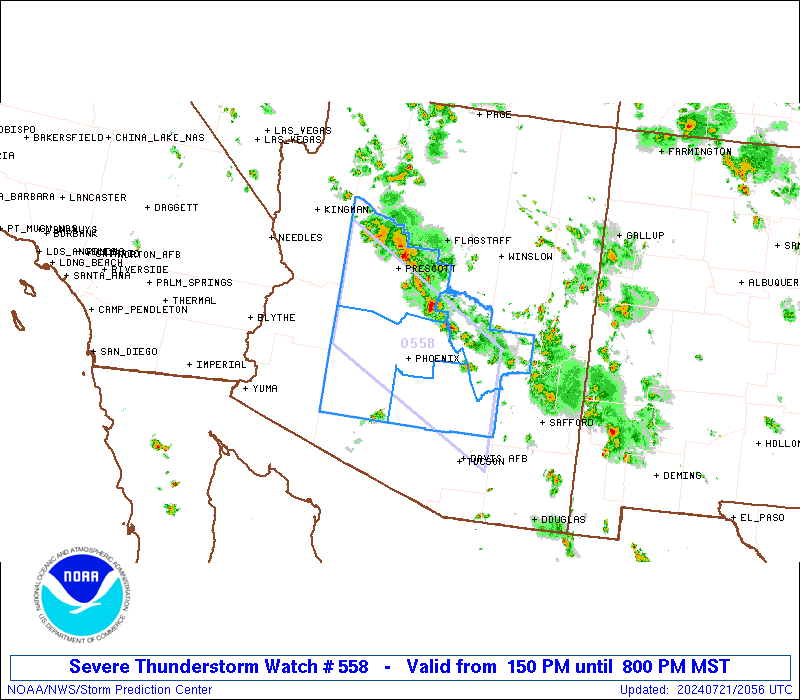
Severe Thunderstorm Watch Number 558
NWS Storm Prediction Center Norman OK
150 PM MST Sun Jul 21 2024
The NWS Storm Prediction Center has issued a
* Severe Thunderstorm Watch for portions of
Central and South-Central Arizona
* Effective this Sunday afternoon and evening from 150 PM until
800 PM MST.
* Primary threats include...
Scattered damaging winds likely with isolated significant gusts
to 75 mph possible
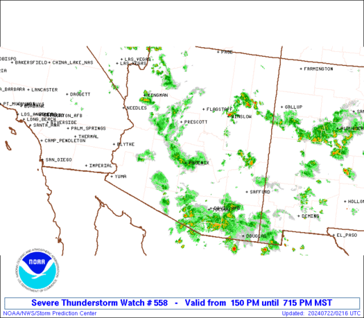
SUMMARY...A broken linear cluster of thunderstorms will move
southward through the afternoon into the evening across the Watch
area. The stronger thunderstorm cores and associated thunderstorm
outflow will be potentially capable of 60 to 75 mph gusts as this
activity moves into the lower deserts. Marginally severe hail
(diameter up to 1 inch) may accompany the stronger thunderstorms
this afternoon near the Mogollon Rim.
The severe thunderstorm watch area is approximately along and 60
statute miles north and south of a line from 55 miles west southwest
of Prescott AZ to 95 miles east southeast of Phoenix AZ. For a
complete depiction of the watch see the associated watch outline
update (WOUS64 KWNS WOU8).
PRECAUTIONARY/PREPAREDNESS ACTIONS...
REMEMBER...A Severe Thunderstorm Watch means conditions are
favorable for severe thunderstorms in and close to the watch area.
Persons in these areas should be on the lookout for threatening
weather conditions and listen for later statements and possible
warnings. Severe thunderstorms can and occasionally do produce
tornadoes.
&&
AVIATION...A few severe thunderstorms with hail surface and aloft to
1 inch. Extreme turbulence and surface wind gusts to 65 knots. A few
cumulonimbi with maximum tops to 500. Mean storm motion vector
01015.
...Smith
 Note:
The Aviation Watch (SAW) product is an approximation to the watch area.
The actual watch is depicted by the shaded areas.
Note:
The Aviation Watch (SAW) product is an approximation to the watch area.
The actual watch is depicted by the shaded areas.
   SAW8
   WW 558 SEVERE TSTM AZ 212050Z - 220300Z
   AXIS..60 STATUTE MILES NORTH AND SOUTH OF LINE..
   55WSW PRC/PRESCOTT AZ/ - 95ESE PHX/PHOENIX AZ/
   ..AVIATION COORDS.. 50NM N/S /46WSW DRK - 52NNE TUS/
   HAIL SURFACE AND ALOFT..1 INCH. WIND GUSTS..65 KNOTS.
   MAX TOPS TO 500. MEAN STORM MOTION VECTOR 01015.

   LAT...LON 35211331 33751051 32031051 33471331

   THIS IS AN APPROXIMATION TO THE WATCH AREA.  FOR A
   COMPLETE DEPICTION OF THE WATCH SEE WOUS64 KWNS
   FOR WOU8.
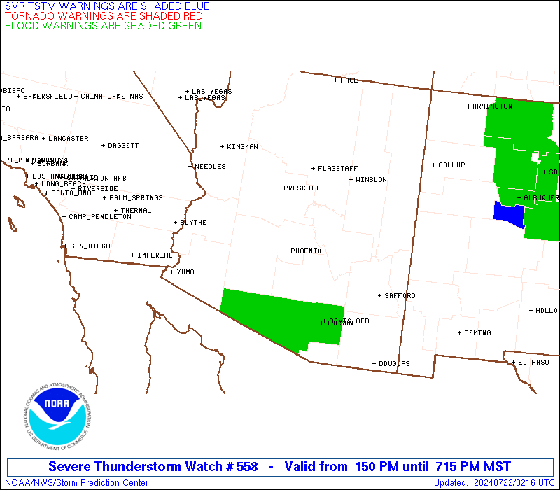
Watch 558 Status Report Messages:
STATUS REPORT #3 ON WW 558

VALID 220100Z - 220240Z

SEVERE WEATHER THREAT CONTINUES RIGHT OF A LINE FROM 70 NW GBN TO
30 ENE TUS.

..LYONS..07/22/24

ATTN...WFO...PSR...FGZ...

&&

STATUS REPORT FOR WS 558

SEVERE WEATHER THREAT CONTINUES FOR THE FOLLOWING AREAS

AZC013-220240-

AZ
.    ARIZONA COUNTIES INCLUDED ARE

MARICOPA
$$


THE WATCH STATUS MESSAGE IS FOR GUIDANCE PURPOSES ONLY.  PLEASE
REFER TO WATCH COUNTY NOTIFICATION STATEMENTS FOR OFFICIAL
INFORMATION ON COUNTIES...INDEPENDENT CITIES AND MARINE ZONES
CLEARED FROM SEVERE THUNDERSTORM AND TORNADO WATCHES.
$$

STATUS REPORT #2 ON WW 558

VALID 220055Z - 220140Z

SEVERE WEATHER THREAT CONTINUES RIGHT OF A LINE FROM 10 NNE PRC
TO 45 NNW TUS TO 15 NE TUS.

..LYONS..07/22/24

ATTN...WFO...PSR...FGZ...

&&

STATUS REPORT FOR WS 558

SEVERE WEATHER THREAT CONTINUES FOR THE FOLLOWING AREAS

AZC013-025-220140-

AZ
.    ARIZONA COUNTIES INCLUDED ARE

MARICOPA	     YAVAPAI
$$


THE WATCH STATUS MESSAGE IS FOR GUIDANCE PURPOSES ONLY.  PLEASE
REFER TO WATCH COUNTY NOTIFICATION STATEMENTS FOR OFFICIAL
INFORMATION ON COUNTIES...INDEPENDENT CITIES AND MARINE ZONES
CLEARED FROM SEVERE THUNDERSTORM AND TORNADO WATCHES.
$$

STATUS REPORT #1 ON WW 558

VALID 212325Z - 220040Z

SEVERE WEATHER THREAT CONTINUES RIGHT OF A LINE FROM 35 E IGM TO
35 SSW PRC TO 40 NNW SAD.

..LYONS..07/21/24

ATTN...WFO...PSR...FGZ...

&&

STATUS REPORT FOR WS 558

SEVERE WEATHER THREAT CONTINUES FOR THE FOLLOWING AREAS

AZC013-021-025-220040-

AZ
.    ARIZONA COUNTIES INCLUDED ARE

MARICOPA	     PINAL		 YAVAPAI
$$


THE WATCH STATUS MESSAGE IS FOR GUIDANCE PURPOSES ONLY.  PLEASE
REFER TO WATCH COUNTY NOTIFICATION STATEMENTS FOR OFFICIAL
INFORMATION ON COUNTIES...INDEPENDENT CITIES AND MARINE ZONES
CLEARED FROM SEVERE THUNDERSTORM AND TORNADO WATCHES.
$$
Note:
Click for Complete Product Text.
Tornadoes
Probability of 2 or more tornadoes
|
Low (<5%)
|
Probability of 1 or more strong (EF2-EF5) tornadoes
|
Low (<2%)
|
Wind
Probability of 10 or more severe wind events
|
Mod (60%)
|
Probability of 1 or more wind events > 65 knots
|
Mod (30%)
|
Hail
Probability of 10 or more severe hail events
|
Low (<5%)
|
Probability of 1 or more hailstones > 2 inches
|
Low (<5%)
|
Combined Severe Hail/Wind
Probability of 6 or more combined severe hail/wind events
|
High (70%)
|
For each watch, probabilities for particular events inside the watch
(listed above in each table) are determined by the issuing forecaster.
The "Low" category contains probability values ranging from less than 2%
to 20% (EF2-EF5 tornadoes), less than 5% to 20% (all other probabilities),
"Moderate" from 30% to 60%, and "High" from 70% to greater than 95%.
High values are bolded and lighter in color to provide awareness of
an increased threat for a particular event.


 @NWSSPC