Note:
The expiration time in the watch graphic is amended if the watch is
replaced, cancelled or extended.
Note:
Note:
The expiration time in the watch graphic is amended if the watch is
replaced, cancelled or extended.
Note: Click for
Watch Status Reports.
   SEL7

   URGENT - IMMEDIATE BROADCAST REQUESTED
   Severe Thunderstorm Watch Number 557
   NWS Storm Prediction Center Norman OK
   500 PM MDT Fri Jul 19 2024

   The NWS Storm Prediction Center has issued a

   * Severe Thunderstorm Watch for portions of
     Far Northeast Colorado
     Western and Central Nebraska
     Southwest South Dakota

   * Effective this Friday afternoon and evening from 500 PM until
     1100 PM MDT.

   * Primary threats include...
     Scattered damaging winds and isolated significant gusts to 75
       mph possible
     Scattered large hail and isolated very large hail events to 2
       inches in diameter possible

   SUMMARY...Ongoing supercells should continue to pose a threat for
   large hail up to 1-2 inches in diameter as they move generally
   southward this evening. Some threat for damaging winds around 60-75
   mph may also exist, especially if a thunderstorm cluster can develop
   later this evening.

   The severe thunderstorm watch area is approximately along and 60
   statute miles east and west of a line from 5 miles east northeast of
   Rapid City SD to 35 miles west southwest of North Platte NE. For a
   complete depiction of the watch see the associated watch outline
   update (WOUS64 KWNS WOU7).

   PRECAUTIONARY/PREPAREDNESS ACTIONS...

   REMEMBER...A Severe Thunderstorm Watch means conditions are
   favorable for severe thunderstorms in and close to the watch area.
   Persons in these areas should be on the lookout for threatening
   weather conditions and listen for later statements and possible
   warnings. Severe thunderstorms can and occasionally do produce
   tornadoes.

   &&

   OTHER WATCH INFORMATION...CONTINUE...WW 555...WW 556...

   AVIATION...A few severe thunderstorms with hail surface and aloft to
   2 inches. Extreme turbulence and surface wind gusts to 65 knots. A
   few cumulonimbi with maximum tops to 500. Mean storm motion vector
   35025.

   ...Gleason
 Note:
The Aviation Watch (SAW) product is an approximation to the watch area.
The actual watch is depicted by the shaded areas.
Note:
The Aviation Watch (SAW) product is an approximation to the watch area.
The actual watch is depicted by the shaded areas.
   SAW7
   WW 557 SEVERE TSTM CO NE SD 192300Z - 200500Z
   AXIS..60 STATUTE MILES EAST AND WEST OF LINE..
   5ENE RAP/RAPID CITY SD/ - 35WSW LBF/NORTH PLATTE NE/
   ..AVIATION COORDS.. 50NM E/W /6NNE RAP - 29WSW LBF/
   HAIL SURFACE AND ALOFT..2 INCHES. WIND GUSTS..65 KNOTS.
   MAX TOPS TO 500. MEAN STORM MOTION VECTOR 35025.

   LAT...LON 44070175 40930015 40930245 44070417

   THIS IS AN APPROXIMATION TO THE WATCH AREA.  FOR A
   COMPLETE DEPICTION OF THE WATCH SEE WOUS64 KWNS
   FOR WOU7.
Watch 557 Status Report Messages:
STATUS REPORT #3 ON WW 557
VALID 200235Z - 200340Z
SEVERE WEATHER THREAT CONTINUES RIGHT OF A LINE FROM 15 SE SNY TO
50 E MCK.
..LYONS..07/20/24
ATTN...WFO...BOU...LBF...CYS...UNR...
&&
STATUS REPORT FOR WS 557
SEVERE WEATHER THREAT CONTINUES FOR THE FOLLOWING AREAS
COC095-200340-
CO
. COLORADO COUNTIES INCLUDED ARE
PHILLIPS
$$
NEC029-200340-
NE
. NEBRASKA COUNTIES INCLUDED ARE
CHASE
$$
THE WATCH STATUS MESSAGE IS FOR GUIDANCE PURPOSES ONLY. PLEASE
REFER TO WATCH COUNTY NOTIFICATION STATEMENTS FOR OFFICIAL
INFORMATION ON COUNTIES...INDEPENDENT CITIES AND MARINE ZONES
CLEARED FROM SEVERE THUNDERSTORM AND TORNADO WATCHES.
$$
STATUS REPORT #2 ON WW 557
VALID 200135Z - 200240Z
SEVERE WEATHER THREAT CONTINUES RIGHT OF A LINE FROM 25 SW BFF TO
10 WSW BBW.
..LYONS..07/20/24
ATTN...WFO...BOU...LBF...CYS...UNR...
&&
STATUS REPORT FOR WS 557
SEVERE WEATHER THREAT CONTINUES FOR THE FOLLOWING AREAS
COC095-115-200240-
CO
. COLORADO COUNTIES INCLUDED ARE
PHILLIPS SEDGWICK
$$
NEC029-049-063-085-101-111-135-200240-
NE
. NEBRASKA COUNTIES INCLUDED ARE
CHASE DEUEL FRONTIER
HAYES KEITH LINCOLN
PERKINS
$$
THE WATCH STATUS MESSAGE IS FOR GUIDANCE PURPOSES ONLY. PLEASE
REFER TO WATCH COUNTY NOTIFICATION STATEMENTS FOR OFFICIAL
INFORMATION ON COUNTIES...INDEPENDENT CITIES AND MARINE ZONES
CLEARED FROM SEVERE THUNDERSTORM AND TORNADO WATCHES.
$$
STATUS REPORT #1 ON WW 557
VALID 200035Z - 200140Z
THE SEVERE WEATHER THREAT CONTINUES ACROSS THE ENTIRE WATCH AREA.
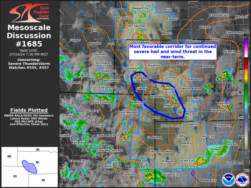
FOR ADDITIONAL INFORMATION SEE MESOSCALE DISCUSSION 1685
..WEINMAN..07/20/24
ATTN...WFO...BOU...LBF...CYS...UNR...
&&
STATUS REPORT FOR WS 557
SEVERE WEATHER THREAT CONTINUES FOR THE FOLLOWING AREAS
COC095-115-200140-
CO
. COLORADO COUNTIES INCLUDED ARE
PHILLIPS SEDGWICK
$$
NEC005-013-029-031-045-049-063-069-075-085-091-101-111-113-117-
123-135-161-171-200140-
NE
. NEBRASKA COUNTIES INCLUDED ARE
ARTHUR BOX BUTTE CHASE
CHERRY DAWES DEUEL
FRONTIER GARDEN GRANT
HAYES HOOKER KEITH
LINCOLN LOGAN MCPHERSON
MORRILL PERKINS SHERIDAN
THOMAS
$$
SDC007-033-047-071-093-102-103-200140-
SD
. SOUTH DAKOTA COUNTIES INCLUDED ARE
BENNETT CUSTER FALL RIVER
JACKSON MEADE OGLALA LAKOTA
PENNINGTON
$$
THE WATCH STATUS MESSAGE IS FOR GUIDANCE PURPOSES ONLY. PLEASE
REFER TO WATCH COUNTY NOTIFICATION STATEMENTS FOR OFFICIAL
INFORMATION ON COUNTIES...INDEPENDENT CITIES AND MARINE ZONES
CLEARED FROM SEVERE THUNDERSTORM AND TORNADO WATCHES.
$$
Note:
Click for Complete Product Text.
Tornadoes
Probability of 2 or more tornadoes
|
Low (<5%)
|
Probability of 1 or more strong (EF2-EF5) tornadoes
|
Low (<2%)
|
Wind
Probability of 10 or more severe wind events
|
Mod (40%)
|
Probability of 1 or more wind events > 65 knots
|
Mod (30%)
|
Hail
Probability of 10 or more severe hail events
|
Mod (50%)
|
Probability of 1 or more hailstones > 2 inches
|
Mod (30%)
|
Combined Severe Hail/Wind
Probability of 6 or more combined severe hail/wind events
|
High (80%)
|
For each watch, probabilities for particular events inside the watch
(listed above in each table) are determined by the issuing forecaster.
The "Low" category contains probability values ranging from less than 2%
to 20% (EF2-EF5 tornadoes), less than 5% to 20% (all other probabilities),
"Moderate" from 30% to 60%, and "High" from 70% to greater than 95%.
High values are bolded and lighter in color to provide awareness of
an increased threat for a particular event.


 @NWSSPC