 Note:
The expiration time in the watch graphic is amended if the watch is
replaced, cancelled or extended.
Note:
Note:
The expiration time in the watch graphic is amended if the watch is
replaced, cancelled or extended.
Note: Click for
Watch Status Reports.
SEL6
URGENT - IMMEDIATE BROADCAST REQUESTED
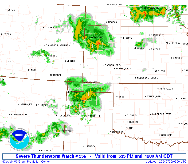
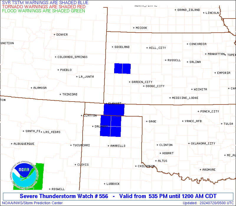
Severe Thunderstorm Watch Number 556
NWS Storm Prediction Center Norman OK
535 PM CDT Fri Jul 19 2024
The NWS Storm Prediction Center has issued a
* Severe Thunderstorm Watch for portions of
Southeast Colorado
Southwest Kansas
Far Northwest Oklahoma and the Oklahoma Panhandle
The Texas Panhandle
* Effective this Friday afternoon from 535 PM until Midnight CDT.
* Primary threats include...
Scattered damaging winds likely with isolated significant gusts
to 75 mph possible
Isolated very large hail events to 2 inches in diameter possible
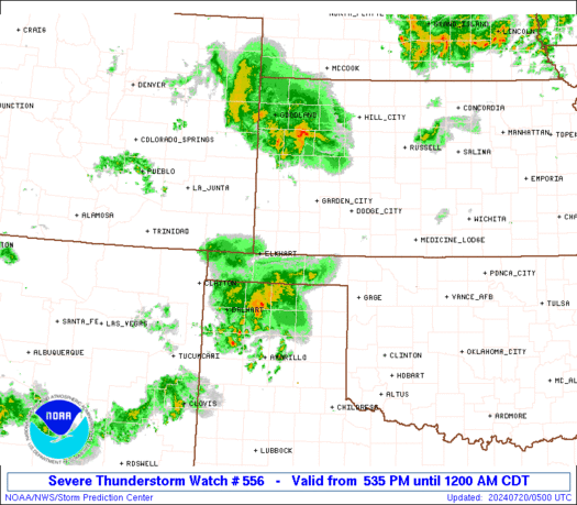
SUMMARY...Thunderstorms should generally move southward this evening
while posing a threat for scattered damaging winds around 60-70 mph,
with isolated stronger gusts possible. Occasional hail around 1-2
inches in diameter may also occur with any persistent supercells.
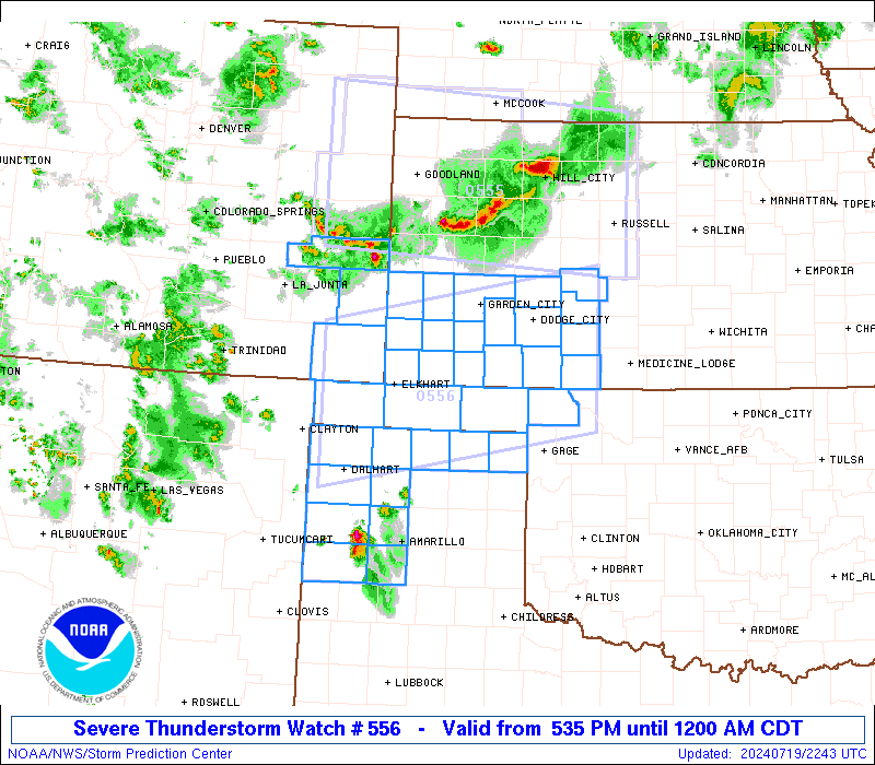
The severe thunderstorm watch area is approximately along and 65
statute miles north and south of a line from 40 miles south
southwest of Springfield CO to 55 miles east southeast of Dodge City
KS. For a complete depiction of the watch see the associated watch
outline update (WOUS64 KWNS WOU6).
PRECAUTIONARY/PREPAREDNESS ACTIONS...
REMEMBER...A Severe Thunderstorm Watch means conditions are
favorable for severe thunderstorms in and close to the watch area.
Persons in these areas should be on the lookout for threatening
weather conditions and listen for later statements and possible
warnings. Severe thunderstorms can and occasionally do produce
tornadoes.
&&
OTHER WATCH INFORMATION...CONTINUE...WW 555...
AVIATION...A few severe thunderstorms with hail surface and aloft to
2 inches. Extreme turbulence and surface wind gusts to 65 knots. A
few cumulonimbi with maximum tops to 500. Mean storm motion vector
34025.
...Gleason
   SEL6

   URGENT - IMMEDIATE BROADCAST REQUESTED
   Severe Thunderstorm Watch Number 556
   NWS Storm Prediction Center Norman OK
   535 PM CDT Fri Jul 19 2024

   The NWS Storm Prediction Center has issued a

   * Severe Thunderstorm Watch for portions of
     Southeast Colorado
     Southwest Kansas
     Far Northwest Oklahoma and the Oklahoma Panhandle
     The Texas Panhandle

   * Effective this Friday afternoon from 535 PM until Midnight CDT.

   * Primary threats include...
     Scattered damaging winds likely with isolated significant gusts
       to 75 mph possible
     Isolated very large hail events to 2 inches in diameter possible

   SUMMARY...Thunderstorms should generally move southward this evening
   while posing a threat for scattered damaging winds around 60-70 mph,
   with isolated stronger gusts possible. Occasional hail around 1-2
   inches in diameter may also occur with any persistent supercells.

   The severe thunderstorm watch area is approximately along and 65
   statute miles north and south of a line from 40 miles south
   southwest of Springfield CO to 55 miles east southeast of Dodge City
   KS. For a complete depiction of the watch see the associated watch
   outline update (WOUS64 KWNS WOU6).

   PRECAUTIONARY/PREPAREDNESS ACTIONS...

   REMEMBER...A Severe Thunderstorm Watch means conditions are
   favorable for severe thunderstorms in and close to the watch area.
   Persons in these areas should be on the lookout for threatening
   weather conditions and listen for later statements and possible
   warnings. Severe thunderstorms can and occasionally do produce
   tornadoes.

   &&

   OTHER WATCH INFORMATION...CONTINUE...WW 555...

   AVIATION...A few severe thunderstorms with hail surface and aloft to
   2 inches. Extreme turbulence and surface wind gusts to 65 knots. A
   few cumulonimbi with maximum tops to 500. Mean storm motion vector
   34025.

   ...Gleason
 Note:
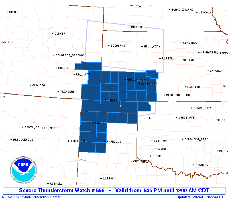
The Aviation Watch (SAW) product is an approximation to the watch area.
The actual watch is depicted by the shaded areas.
Note:
The Aviation Watch (SAW) product is an approximation to the watch area.
The actual watch is depicted by the shaded areas.
   SAW6
   WW 556 SEVERE TSTM CO KS OK TX 192235Z - 200500Z
   AXIS..65 STATUTE MILES NORTH AND SOUTH OF LINE..
   40SSW SPD/SPRINGFIELD CO/ - 55ESE DDC/DODGE CITY KS/
   ..AVIATION COORDS.. 55NM N/S /46SE TBE - 72WSW ICT/
   HAIL SURFACE AND ALOFT..2 INCHES. WIND GUSTS..65 KNOTS.
   MAX TOPS TO 500. MEAN STORM MOTION VECTOR 34025.

   LAT...LON 37680290 38409904 36529904 35800290

   THIS IS AN APPROXIMATION TO THE WATCH AREA.  FOR A
   COMPLETE DEPICTION OF THE WATCH SEE WOUS64 KWNS
   FOR WOU6.
Watch 556 Status Report Messages:
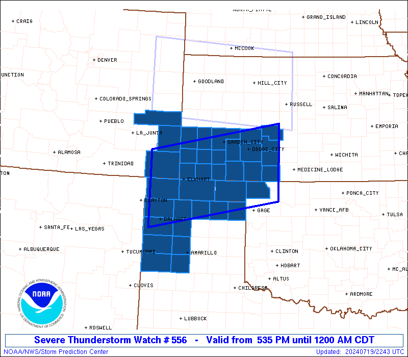
STATUS REPORT #2 ON WW 556

VALID 200235Z - 200340Z

SEVERE WEATHER THREAT CONTINUES RIGHT OF A LINE FROM 40 ESE LAA
TO 25 E EHA TO 35 NNE BGD.

..SPC..07/20/24

ATTN...WFO...PUB...DDC...AMA...OUN...

&&

STATUS REPORT FOR WS 556

SEVERE WEATHER THREAT CONTINUES FOR THE FOLLOWING AREAS

COC009-200340-

CO
.    COLORADO COUNTIES INCLUDED ARE

BACA
$$


OKC025-139-200340-

OK
.    OKLAHOMA COUNTIES INCLUDED ARE

CIMARRON	     TEXAS
$$


TXC111-195-205-421-200340-

TX
.    TEXAS COUNTIES INCLUDED ARE

DALLAM		     HANSFORD		 HARTLEY
SHERMAN
$$


THE WATCH STATUS MESSAGE IS FOR GUIDANCE PURPOSES ONLY.  PLEASE
REFER TO WATCH COUNTY NOTIFICATION STATEMENTS FOR OFFICIAL
INFORMATION ON COUNTIES...INDEPENDENT CITIES AND MARINE ZONES
CLEARED FROM SEVERE THUNDERSTORM AND TORNADO WATCHES.
$$

STATUS REPORT #1 ON WW 556

VALID 192340Z - 200040Z

THE SEVERE WEATHER THREAT CONTINUES ACROSS THE ENTIRE WATCH AREA.

..SPC..07/19/24

ATTN...WFO...PUB...DDC...AMA...OUN...

&&

STATUS REPORT FOR WS 556

SEVERE WEATHER THREAT CONTINUES FOR THE FOLLOWING AREAS

COC009-061-099-200040-

CO
.    COLORADO COUNTIES INCLUDED ARE

BACA		     KIOWA		 PROWERS
$$


KSC025-033-047-055-057-067-069-075-081-083-093-097-119-129-145-
175-187-189-200040-

KS
.    KANSAS COUNTIES INCLUDED ARE

CLARK		     COMANCHE		 EDWARDS
FINNEY		     FORD		 GRANT
GRAY		     HAMILTON		 HASKELL
HODGEMAN	     KEARNY		 KIOWA
MEADE		     MORTON		 PAWNEE
SEWARD		     STANTON		 STEVENS
$$


OKC007-025-059-139-200040-

OK
.    OKLAHOMA COUNTIES INCLUDED ARE

BEAVER		     CIMARRON		 HARPER
TEXAS
$$


TXC111-117-195-205-295-341-357-359-375-381-421-200040-

TX
.    TEXAS COUNTIES INCLUDED ARE

DALLAM		     DEAF SMITH 	 HANSFORD
HARTLEY 	     LIPSCOMB		 MOORE
OCHILTREE	     OLDHAM		 POTTER
RANDALL 	     SHERMAN
$$


THE WATCH STATUS MESSAGE IS FOR GUIDANCE PURPOSES ONLY.  PLEASE
REFER TO WATCH COUNTY NOTIFICATION STATEMENTS FOR OFFICIAL
INFORMATION ON COUNTIES...INDEPENDENT CITIES AND MARINE ZONES
CLEARED FROM SEVERE THUNDERSTORM AND TORNADO WATCHES.
$$
Note:
Click for Complete Product Text.
Tornadoes
Probability of 2 or more tornadoes
|
Low (<5%)
|
Probability of 1 or more strong (EF2-EF5) tornadoes
|
Low (<2%)
|
Wind
Probability of 10 or more severe wind events
|
Mod (60%)
|
Probability of 1 or more wind events > 65 knots
|
Mod (30%)
|
Hail
Probability of 10 or more severe hail events
|
Mod (30%)
|
Probability of 1 or more hailstones > 2 inches
|
Mod (30%)
|
Combined Severe Hail/Wind
Probability of 6 or more combined severe hail/wind events
|
High (90%)
|
For each watch, probabilities for particular events inside the watch
(listed above in each table) are determined by the issuing forecaster.
The "Low" category contains probability values ranging from less than 2%
to 20% (EF2-EF5 tornadoes), less than 5% to 20% (all other probabilities),
"Moderate" from 30% to 60%, and "High" from 70% to greater than 95%.
High values are bolded and lighter in color to provide awareness of
an increased threat for a particular event.


 @NWSSPC