|
| Mesoscale Discussion 132 |
|
< Previous MD Next MD >
|
|
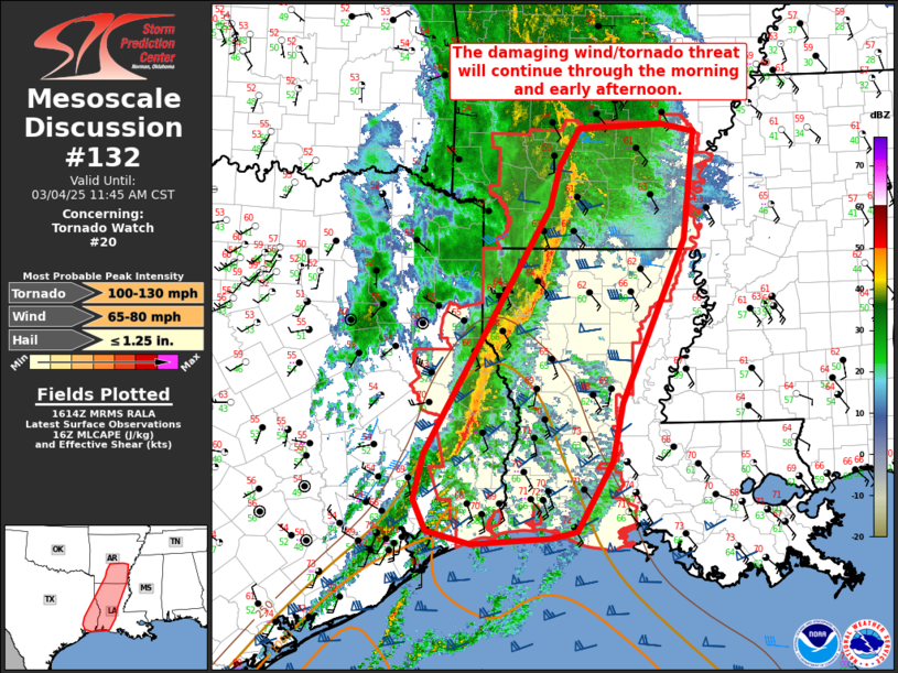
   Mesoscale Discussion 0132
   NWS Storm Prediction Center Norman OK
   1017 AM CST Tue Mar 04 2025

   Areas affected...southern Arkansas...far east Texas...and much of
   western Louisiana

   Concerning...Tornado Watch 20...

   Valid 041617Z - 041745Z

   The severe weather threat for Tornado Watch 20 continues.

   SUMMARY...The damaging wind/tornado threat will continue through the
   morning and early afternoon.

   DISCUSSION...A mature squall line has developed from southern
   Arkansas to far east Texas. Damaging wind gusts are the primary
   threat with this squall line, but several mesovorticies have also
   been observed across northern Louisiana. This portion of the line
   has now outrun the better low-level moisture and thus, any
   mesovorticies have been relatively weak and short lived. Expect this
   line of storms to continue east through the morning and into the
   early afternoon with a similar intensity.

   The greatest tornado threat during the next few hours will likely
   exist across southern and central Louisiana where mid to upper 60s
   dewpoints are in place with 500+ J/kg MLCAPE and 450 m2/s2 0-1km SRH
   (per POE VWP). If enough breaks in the clouds can sustain for
   temperatures to warm into the low 70s with 1000+ J/kg MLCAPE, an
   increase in the supercellular tornado threat may occur with a
   subsequent greater strong tornado threat.

   ..Bentley.. 03/04/2025

   ...Please see www.spc.noaa.gov for graphic product...

   ATTN...WFO...JAN...LZK...LCH...SHV...HGX...

   LAT...LON   33489311 33979298 34409271 34469158 34369114 33129129
               31239213 30559227 29759274 29669311 29639376 29599417
               29749477 30119494 30649480 33489311
|
|
Top/All Mesoscale Discussions/Forecast Products/Home
|
|


 @NWSSPC