|
| Mesoscale Discussion 133 |
|
< Previous MD Next MD >
|
|
Mesoscale Discussion 0133
NWS Storm Prediction Center Norman OK
1025 AM CST Tue Mar 04 2025
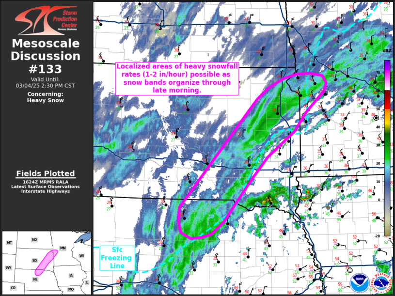
Areas affected...Eastern South Dakota into far southwestern
Minnesota and far northern Nebraska
Concerning...Heavy snow
Valid 041625Z - 042030Z
SUMMARY...Localized moderate to heavy snowfall rates on the order of
1-2 inches/hour will be possible as snow bands develop across
eastern South Dakota into far western Minnesota and far northern
Nebraska.
DISCUSSION...Transient snow banding has been observed across eastern
SD into northern NE over the past couple of hours with surface
observations and web cams under these bands showing localized areas
of visibility reductions down to 1/4 to 1/2 mile. These bands are
largely being driven by focused ascent within a 700 mb deformation
zone augmented by modest warm advection/frontogenesis through the
850-700 mb layer. Additionally, steep lapse rates within this zone
are supporting localized areas of convectively-augmented
precipitation rates (as evidenced by recent lightning strikes over
the SD/NE/IA border). This deformation zone will continue to be a
preferential area of transient precipitation band development
through the late morning and early afternoon hours. Areas to the
north/northwest of the surface freezing line may experience periods
of moderate to heavy snowfall rates (1-2 inches/hour) as transient
snow bands emerge. Given surface gradient winds sustained at 20-25
mph (gusting to 30-40 mph at times), localized areas of whiteout
conditions (visibility below 1/4 mile) appear possible under more
organized bands.
..Moore.. 03/04/2025
...Please see www.spc.noaa.gov for graphic product...
ATTN...WFO...MPX...FGF...FSD...ABR...LBF...UNR...
LAT...LON 44529661 43949746 43539787 43049832 42509879 42229916
42159944 42129978 42260007 42520015 42810014 44979804
45249776 45479742 45689693 45789655 45809614 45739572
45589560 45419567 45309580 45109603 44929625 44529661
|
|
Top/All Mesoscale Discussions/Forecast Products/Home
|
|


 @NWSSPC