|
| Mesoscale Discussion 131 |
|
< Previous MD Next MD >
|
|
Mesoscale Discussion 0131
NWS Storm Prediction Center Norman OK
0856 AM CST Tue Mar 04 2025
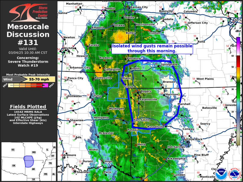
Areas affected...Isolated wind gusts remain possible through this
morning.
Concerning...Severe Thunderstorm Watch 19...
Valid 041456Z - 041630Z
The severe weather threat for Severe Thunderstorm Watch 19
continues.
SUMMARY...Isolated wind gusts remain possible through this morning.
DISCUSSION...The intensity of the squall line across northeast
Oklahoma has weakened over the past 30 minutes as it moves into an
increasingly stable/cool downstream airmass. Some recovery may may
continue to occur across northern Arkansas and southern Missouri
which may provide just enough instability to maintain the squall
line as it continues east. Given the very strong low-level flow, (60
knots at 1km per SRX VWP), some threat for isolated severe wind
gusts may continue despite the less intense squall line,
particularly in the southern portions of watch 19 where mid-50s
dewpoints and slightly greater instability are present.
..Bentley.. 03/04/2025
...Please see www.spc.noaa.gov for graphic product...
ATTN...WFO...LZK...SGF...TSA...
LAT...LON 35399440 35989455 36439464 36769487 37229476 37409421
37399289 36939260 36299244 35639262 35209322 35169382
35219441 35399440
|
|
Top/All Mesoscale Discussions/Forecast Products/Home
|
|


 @NWSSPC