 Note:
The expiration time in the watch graphic is amended if the watch is
replaced, cancelled or extended.
Note:
Note:
The expiration time in the watch graphic is amended if the watch is
replaced, cancelled or extended.
Note: Click for
Watch Status Reports.
SEL9
URGENT - IMMEDIATE BROADCAST REQUESTED
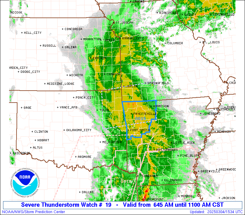
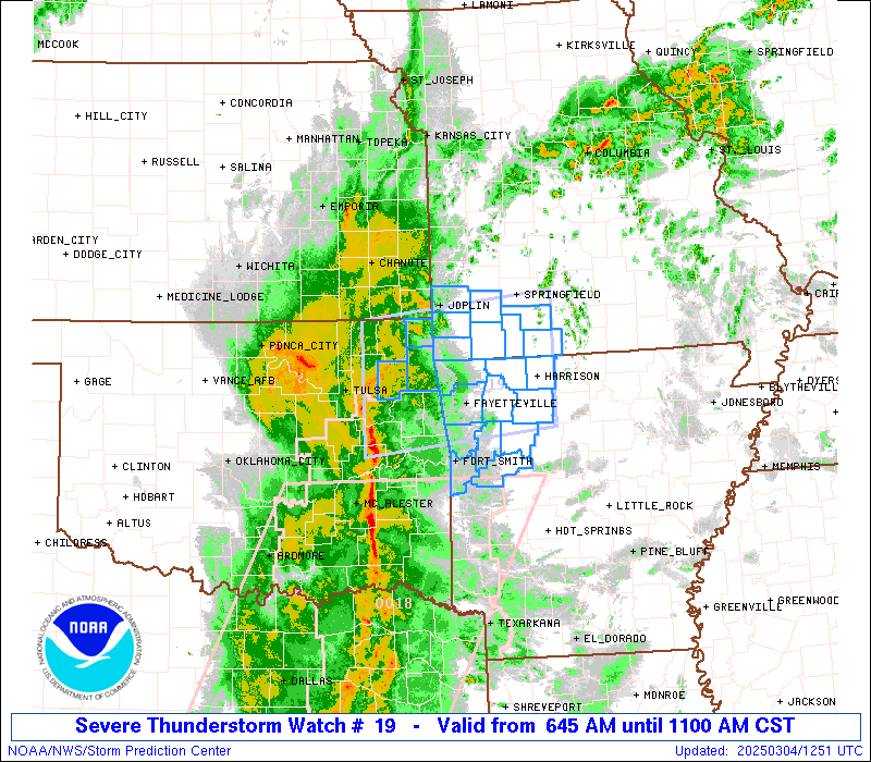
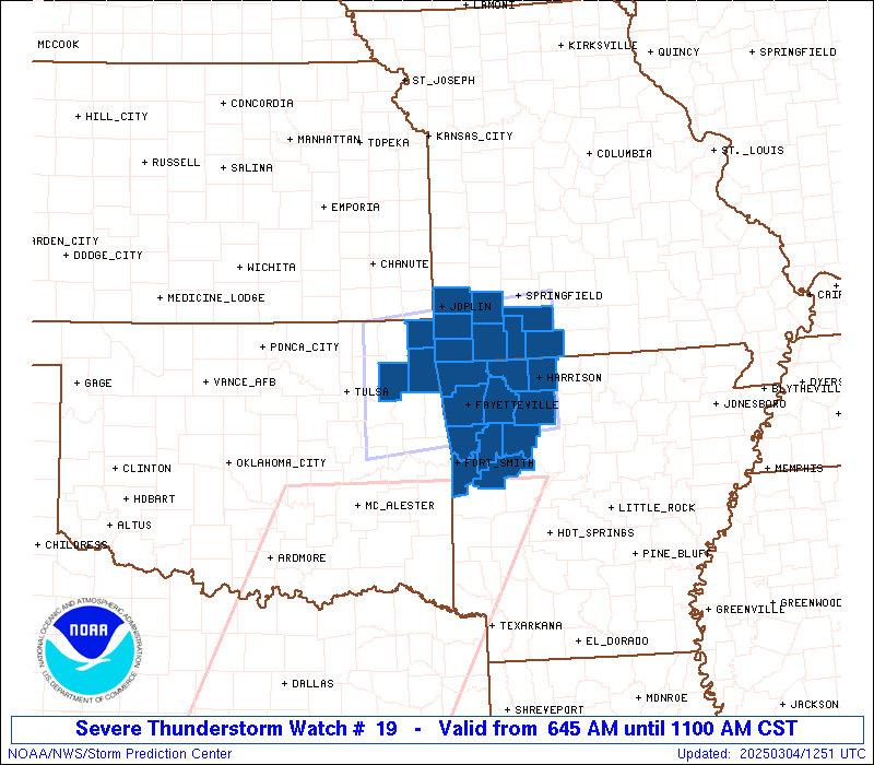
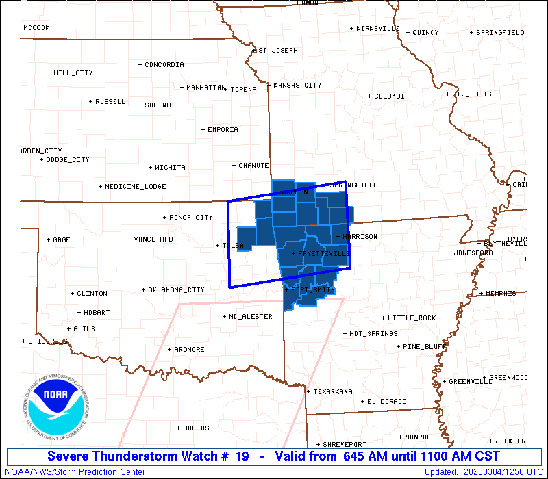
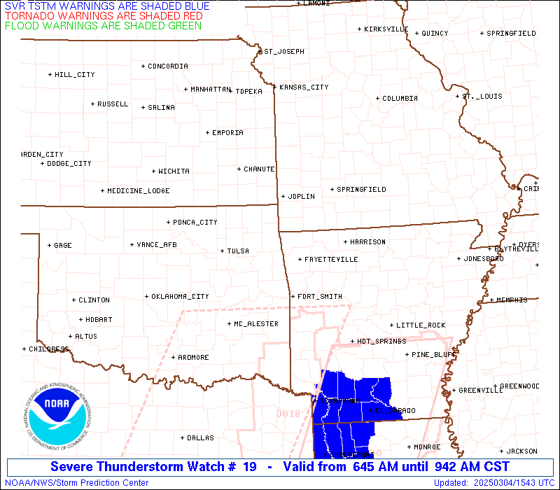
Severe Thunderstorm Watch Number 19
NWS Storm Prediction Center Norman OK
645 AM CST Tue Mar 4 2025
The NWS Storm Prediction Center has issued a
* Severe Thunderstorm Watch for portions of
Northwest Arkansas
Southwest Missouri
Far Northeast Oklahoma
* Effective this Tuesday morning from 645 AM until 1100 AM CST.
* Primary threats include...
Scattered damaging wind gusts to 70 mph possible
Isolated large hail events to 1 inch in diameter possible
A tornado or two possible
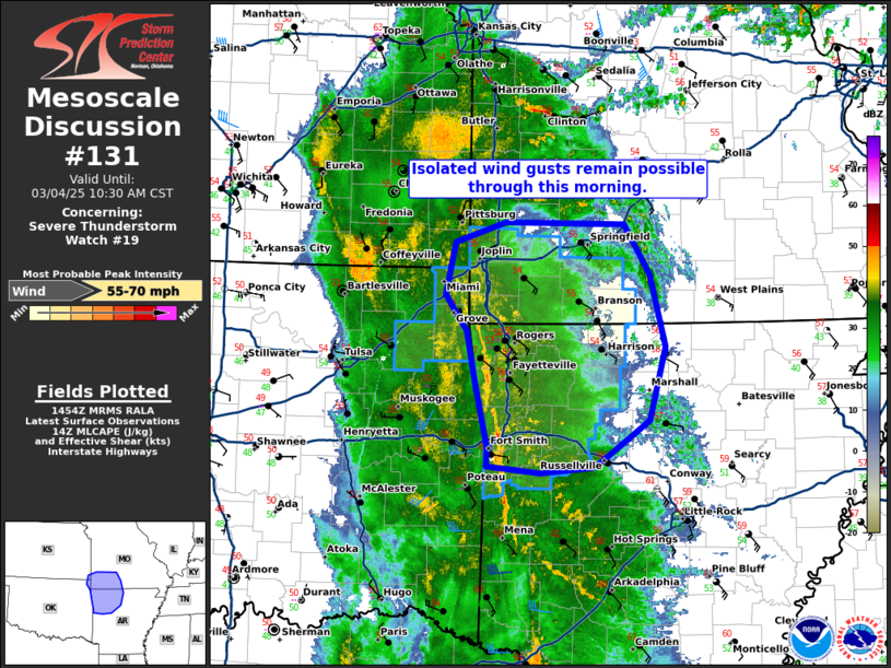
SUMMARY...A severe squall line will continue northeast into the
Watch area, and likely pose a risk for severe gusts (60-70 mph) and
perhaps a threat for a brief tornado, with the more intense portions
of the line.
The severe thunderstorm watch area is approximately along and 55
statute miles north and south of a line from 40 miles north
northwest of Muskogee OK to 20 miles northeast of Harrison AR. For a
complete depiction of the watch see the associated watch outline
update (WOUS64 KWNS WOU9).
PRECAUTIONARY/PREPAREDNESS ACTIONS...
REMEMBER...A Severe Thunderstorm Watch means conditions are
favorable for severe thunderstorms in and close to the watch area.
Persons in these areas should be on the lookout for threatening
weather conditions and listen for later statements and possible
warnings. Severe thunderstorms can and occasionally do produce
tornadoes.
&&
OTHER WATCH INFORMATION...CONTINUE...WW 18...
AVIATION...A few severe thunderstorms with hail surface and aloft to
1 inch. Extreme turbulence and surface wind gusts to 60 knots. A few
cumulonimbi with maximum tops to 350. Mean storm motion vector
23040.
...Smith

   SEL9

   URGENT - IMMEDIATE BROADCAST REQUESTED
   Severe Thunderstorm Watch Number 19
   NWS Storm Prediction Center Norman OK
   645 AM CST Tue Mar 4 2025

   The NWS Storm Prediction Center has issued a

   * Severe Thunderstorm Watch for portions of
     Northwest Arkansas
     Southwest Missouri
     Far Northeast Oklahoma

   * Effective this Tuesday morning from 645 AM until 1100 AM CST.

   * Primary threats include...
     Scattered damaging wind gusts to 70 mph possible
     Isolated large hail events to 1 inch in diameter possible
     A tornado or two possible

   SUMMARY...A severe squall line will continue northeast into the
   Watch area, and likely pose a risk for severe gusts (60-70 mph) and
   perhaps a threat for a brief tornado, with the more intense portions
   of the line.

   The severe thunderstorm watch area is approximately along and 55
   statute miles north and south of a line from 40 miles north
   northwest of Muskogee OK to 20 miles northeast of Harrison AR. For a
   complete depiction of the watch see the associated watch outline
   update (WOUS64 KWNS WOU9).

   PRECAUTIONARY/PREPAREDNESS ACTIONS...

   REMEMBER...A Severe Thunderstorm Watch means conditions are
   favorable for severe thunderstorms in and close to the watch area.
   Persons in these areas should be on the lookout for threatening
   weather conditions and listen for later statements and possible
   warnings. Severe thunderstorms can and occasionally do produce
   tornadoes.

   &&

   OTHER WATCH INFORMATION...CONTINUE...WW 18...

   AVIATION...A few severe thunderstorms with hail surface and aloft to
   1 inch. Extreme turbulence and surface wind gusts to 60 knots. A few
   cumulonimbi with maximum tops to 350. Mean storm motion vector
   23040.

   ...Smith
 Note:
The Aviation Watch (SAW) product is an approximation to the watch area.
The actual watch is depicted by the shaded areas.
Note:
The Aviation Watch (SAW) product is an approximation to the watch area.
The actual watch is depicted by the shaded areas.
SAW9
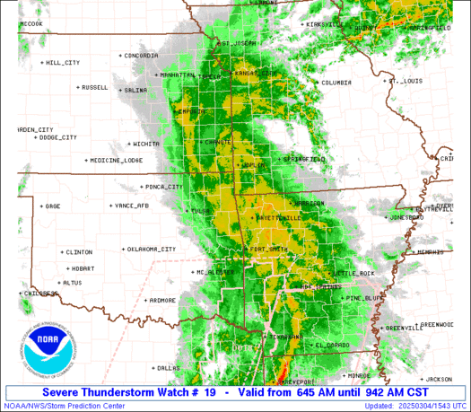
WW 19 SEVERE TSTM AR MO OK 041245Z - 041700Z
AXIS..55 STATUTE MILES NORTH AND SOUTH OF LINE..
40NNW MKO/MUSKOGEE OK/ - 20NE HRO/HARRISON AR/
..AVIATION COORDS.. 50NM N/S /7E TUL - 57SSE SGF/
HAIL SURFACE AND ALOFT..1 INCH. WIND GUSTS..60 KNOTS.
MAX TOPS TO 350. MEAN STORM MOTION VECTOR 23040.
LAT...LON 37009564 37279290 35689290 35419564
THIS IS AN APPROXIMATION TO THE WATCH AREA. FOR A
COMPLETE DEPICTION OF THE WATCH SEE WOUS64 KWNS
FOR WOU9.
Watch 19 Status Report Messages:
STATUS REPORT #3 ON WW 19

VALID 041535Z - 041640Z

SEVERE WEATHER THREAT CONTINUES RIGHT OF A LINE FROM 25 WNW FSM
TO 5 SSE FYV TO 5 NNW HRO TO 20 NW FLP.

..BENTLEY..03/04/25

ATTN...WFO...TSA...LZK...SGF...

&&

STATUS REPORT FOR WS 19

SEVERE WEATHER THREAT CONTINUES FOR THE FOLLOWING AREAS

ARC033-047-071-083-087-101-131-143-041640-

AR
.    ARKANSAS COUNTIES INCLUDED ARE

CRAWFORD	     FRANKLIN		 JOHNSON
LOGAN		     MADISON		 NEWTON
SEBASTIAN	     WASHINGTON
$$


THE WATCH STATUS MESSAGE IS FOR GUIDANCE PURPOSES ONLY.  PLEASE
REFER TO WATCH COUNTY NOTIFICATION STATEMENTS FOR OFFICIAL
INFORMATION ON COUNTIES...INDEPENDENT CITIES AND MARINE ZONES
CLEARED FROM SEVERE THUNDERSTORM AND TORNADO WATCHES.
$$

STATUS REPORT #2 ON WW 19

VALID 041445Z - 041540Z

SEVERE WEATHER THREAT CONTINUES RIGHT OF A LINE FROM 20 WNW FSM
TO 20 SSW GMJ TO 40 SSE CNU.

..SUPINIE..03/04/25

ATTN...WFO...TSA...LZK...SGF...

&&

STATUS REPORT FOR WS 19

SEVERE WEATHER THREAT CONTINUES FOR THE FOLLOWING AREAS

ARC007-009-015-033-047-071-083-087-101-131-143-041540-

AR
.    ARKANSAS COUNTIES INCLUDED ARE

BENTON		     BOONE		 CARROLL
CRAWFORD	     FRANKLIN		 JOHNSON
LOGAN		     MADISON		 NEWTON
SEBASTIAN	     WASHINGTON
$$


MOC009-043-097-109-119-145-209-213-041540-

MO
.    MISSOURI COUNTIES INCLUDED ARE

BARRY		     CHRISTIAN		 JASPER
LAWRENCE	     MCDONALD		 NEWTON
STONE		     TANEY
$$


OKC041-115-041540-

OK
.    OKLAHOMA COUNTIES INCLUDED ARE

DELAWARE	     OTTAWA
$$


THE WATCH STATUS MESSAGE IS FOR GUIDANCE PURPOSES ONLY.  PLEASE
REFER TO WATCH COUNTY NOTIFICATION STATEMENTS FOR OFFICIAL
INFORMATION ON COUNTIES...INDEPENDENT CITIES AND MARINE ZONES
CLEARED FROM SEVERE THUNDERSTORM AND TORNADO WATCHES.
$$

STATUS REPORT #1 ON WW 19

VALID 041350Z - 041440Z

THE SEVERE WEATHER THREAT CONTINUES ACROSS THE ENTIRE WATCH AREA.

..BENTLEY..03/04/25

ATTN...WFO...TSA...LZK...SGF...

&&

STATUS REPORT FOR WS 19

SEVERE WEATHER THREAT CONTINUES FOR THE FOLLOWING AREAS

ARC007-009-015-033-047-071-083-087-101-131-143-041440-

AR
.    ARKANSAS COUNTIES INCLUDED ARE

BENTON		     BOONE		 CARROLL
CRAWFORD	     FRANKLIN		 JOHNSON
LOGAN		     MADISON		 NEWTON
SEBASTIAN	     WASHINGTON
$$


MOC009-043-097-109-119-145-209-213-041440-

MO
.    MISSOURI COUNTIES INCLUDED ARE

BARRY		     CHRISTIAN		 JASPER
LAWRENCE	     MCDONALD		 NEWTON
STONE		     TANEY
$$


OKC041-097-115-041440-

OK
.    OKLAHOMA COUNTIES INCLUDED ARE

DELAWARE	     MAYES		 OTTAWA
$$


THE WATCH STATUS MESSAGE IS FOR GUIDANCE PURPOSES ONLY.  PLEASE
REFER TO WATCH COUNTY NOTIFICATION STATEMENTS FOR OFFICIAL
INFORMATION ON COUNTIES...INDEPENDENT CITIES AND MARINE ZONES
CLEARED FROM SEVERE THUNDERSTORM AND TORNADO WATCHES.
$$
Note:
Click for Complete Product Text.
Tornadoes
Probability of 2 or more tornadoes
|
Low (20%)
|
Probability of 1 or more strong (EF2-EF5) tornadoes
|
Low (5%)
|
Wind
Probability of 10 or more severe wind events
|
Mod (40%)
|
Probability of 1 or more wind events > 65 knots
|
Low (20%)
|
Hail
Probability of 10 or more severe hail events
|
Low (20%)
|
Probability of 1 or more hailstones > 2 inches
|
Low (<5%)
|
Combined Severe Hail/Wind
Probability of 6 or more combined severe hail/wind events
|
Mod (60%)
|
For each watch, probabilities for particular events inside the watch
(listed above in each table) are determined by the issuing forecaster.
The "Low" category contains probability values ranging from less than 2%
to 20% (EF2-EF5 tornadoes), less than 5% to 20% (all other probabilities),
"Moderate" from 30% to 60%, and "High" from 70% to greater than 95%.
High values are bolded and lighter in color to provide awareness of
an increased threat for a particular event.


 @NWSSPC