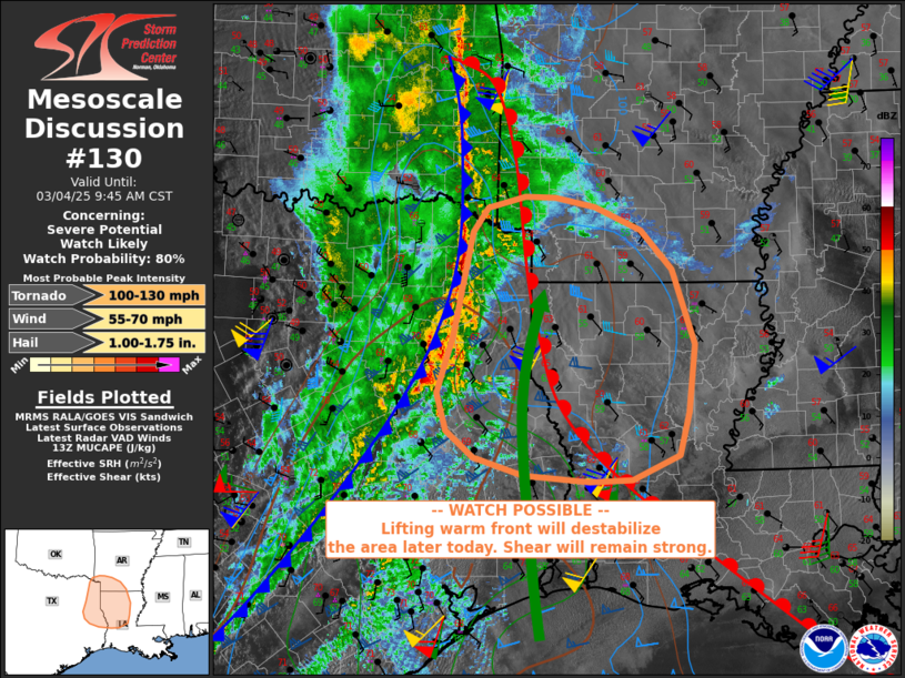
   Mesoscale Discussion 0130
   NWS Storm Prediction Center Norman OK
   0749 AM CST Tue Mar 04 2025

   Areas affected...Arklatex into the Sabine Valley and vicinity

   Concerning...Severe potential...Watch likely

   Valid 041349Z - 041545Z

   Probability of Watch Issuance...80 percent

   SUMMARY...A severe wind, and eventually tornado risk exists over the
   area, ahead of the cold front and near and south of the warm front.
   A watch may be considered.

   DISCUSSION...Although a greater threat of severe storms including
   tornadoes is expected into the afternoon, some severe risk may
   persist with the ongoing early day activity as a line of storms
   continues east out of TX and eastern OK.

   12Z soundings indicate a capping inversion near 700 mb, by virtue of
   relatively cool surface conditions near the warm front. However,
   very strong southerly winds above the surface with the low-level
   jet, as well as areas of daytime heating will allow for a growing
   area of concern across the developing warm sector, including much of
   LA and into MS.

   In the near term, robust storms persist along the cold front over
   northeast TX, with a few counties width of warm sector west of the
   warm front. At least a few hours of severe risk likely remains in
   this area, prior to expected diurnal maximum, and a watch will
   likely be needed to address this early threat.

   ..Jewell/Smith.. 03/04/2025

   ...Please see www.spc.noaa.gov for graphic product...

   ATTN...WFO...JAN...LZK...LCH...SHV...HGX...

   LAT...LON   31159476 31429509 31829522 32449501 33549478 33809458
               33929411 33919374 33819323 33569266 33149227 32349199
               31639206 31169219 30919278 30899330 30959413 31159476
|


 @NWSSPC