|
| Mesoscale Discussion 103 |
|
< Previous MD Next MD >
|
|
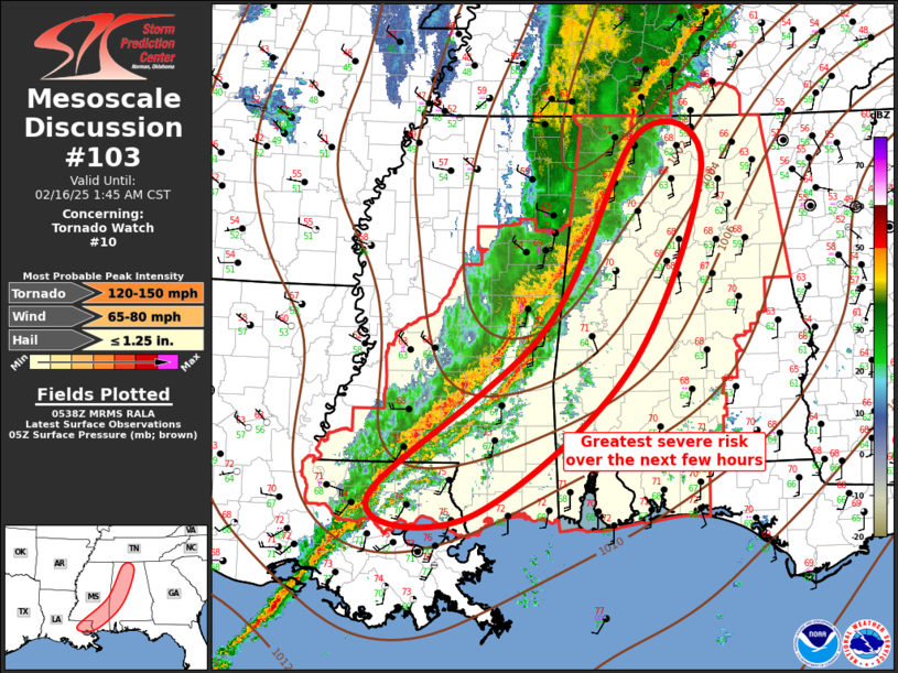
   Mesoscale Discussion 0103
   NWS Storm Prediction Center Norman OK
   1140 PM CST Sat Feb 15 2025

   Areas affected...Central Gulf States

   Concerning...Tornado Watch 10...

   Valid 160540Z - 160745Z

   The severe weather threat for Tornado Watch 10 continues.

   SUMMARY...Severe threat will continue shifting east across the
   central Gulf States. Damaging winds can be expected, along with a
   risk for tornadoes.

   DISCUSSION...Mature squall line has developed ahead of the cold
   front and the leading edge of this activity currently extends from
   middle TN-northwest AL-southern MS-southeast LA. Cold front appears
   to be undercutting much of this QLCS, especially from MS, AL, into
   TN. Pre-squall line supercells have struggled to organize, thus the
   predominant severe mode has been more linear in nature, and this is
   expected given the strongly forced boundary. While QLCS will remain
   the primary mode, scattered weak showers continue to develop ahead
   of the line across southeast LA/southeast MS into southern AL.
   Boundary layer is a bit more unstable at these lower latitudes and
   there is some concern that a few discrete supercells may ultimately
   emerge along this corridor. If not, damaging winds should be
   expected along the QLCS as it propagates steadily east ahead of the
   front.

   ..Darrow.. 02/16/2025

   ...Please see www.spc.noaa.gov for graphic product...

   ATTN...WFO...BMX...HUN...MOB...JAN...LIX...

   LAT...LON   30589094 32508860 34788731 34428641 32068745 30398955
               30589094
|
|
Top/All Mesoscale Discussions/Forecast Products/Home
|
|


 @NWSSPC