|
| Mesoscale Discussion 104 |
|
< Previous MD
|
|
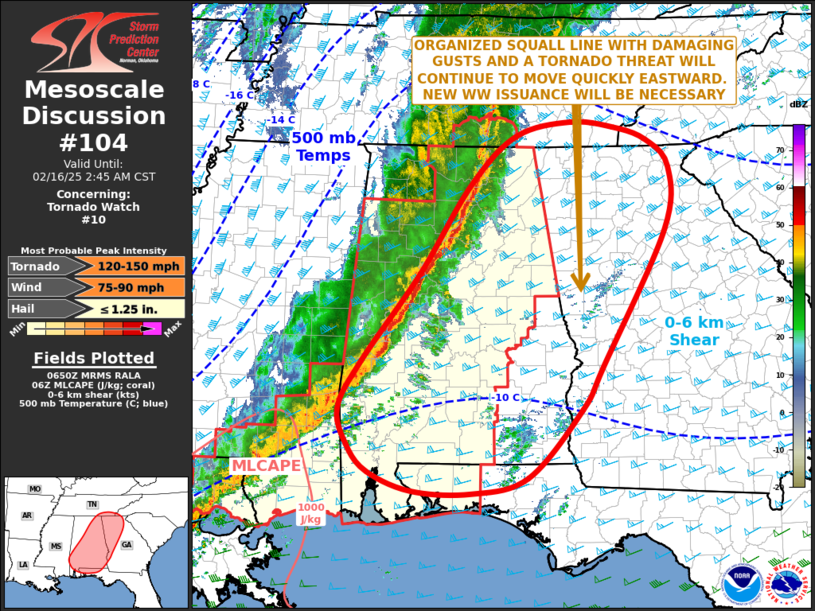
   Mesoscale Discussion 0104
   NWS Storm Prediction Center Norman OK
   1251 AM CST Sun Feb 16 2025

   Areas affected...Alabama...Florida Panhandle...Georgia...Southeast
   Tennessee...Far Western North Carolina

   Concerning...Tornado Watch 10...

   Valid 160651Z - 160845Z

   The severe weather threat for Tornado Watch 10 continues.

   SUMMARY...A severe threats for wind damage and a few tornadoes will
   move quickly eastward across into western and northern Georgia, and
   across the remainder of southern and eastern Alabama during the
   early morning. New weather watch will be necessary ahead of the
   ongoing line.

   DISCUSSION...A mid-level trough will move quickly eastward across
   the lower to mid Mississippi Valley over the next few hours, as a
   surface low moves into the central Appalachians. An associated front
   is located over the central Gulf Coast states, with an organized
   squall line located ahead of the front. A narrow corridor of
   instability is analyzed ahead of the front, with surface dewpoints
   generally in the 60s F. In addition, RAP analysis shows a strong low
   to mid-level jet from eastern Mississippi northeastward into the
   southern Appalachians. 0-6 km shear is estimated to be in 65 to 80
   knot range along this corridor and storm-relative helicity is very
   strong. This will continue to support a widespread severe threat
   over the next few hours. Severe gusts will be likely along the
   leading edge of the squall line and a few tornadoes also possible.

   ..Broyles.. 02/16/2025

   ...Please see www.spc.noaa.gov for graphic product...

   ATTN...WFO...GSP...MRX...FFC...TAE...BMX...HUN...MOB...

   LAT...LON   34728355 35078390 35238439 35298503 35128586 34488656
               33398730 32278817 31678850 31228835 30898805 30648741
               30618652 30828569 31678489 32228456 33938362 34728355
|
|
Top/All Mesoscale Discussions/Forecast Products/Home
|
|


 @NWSSPC