|
| Mesoscale Discussion 102 |
|
< Previous MD Next MD >
|
|
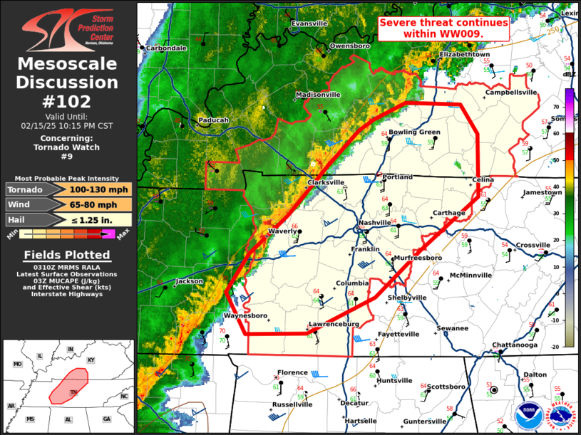
   Mesoscale Discussion 0102
   NWS Storm Prediction Center Norman OK
   0913 PM CST Sat Feb 15 2025

   Areas affected...Middle Tennessee and Southern Kentucky

   Concerning...Tornado Watch 9...

   Valid 160313Z - 160415Z

   The severe weather threat for Tornado Watch 9 continues.

   SUMMARY...Severe threat continues within WW009.

   DISCUSSION...A line of thunderstorms continues to track east
   northeast across portions of Middle Tennessee and southern Kentucky.
   Storms embedded within the line have shown transient rotation, with
   instances of hail up to golf ball and damaging wind. With eastward
   advancements, storms have begun outpacing the more unstable air
   mass. Dew points into the 60s remain as far north as far southern
   Kentucky. However, 00z sounding from BNA shows low level CIN and
   poor distribution of MLCAPE within the profile. Across east
   Tennessee, dew points in the mid to upper 50s are more common with
   temperatures cooling rapidly with eastward extent.

   Shear profiles remain very strong, with deep layer shear around
   45-50 kts and 0-3 km SRH around 600 m2/s2. Despite the decreasingly
   favorable thermal environment, deep layer shear will likely favor
   continued organization and risk for damaging wind, given recent
   trends in a more elongated line with bowing segments. Embedded
   MESOVORTEX within the line may still pose a risk for tornadoes.

   ..Thornton.. 02/16/2025

   ...Please see www.spc.noaa.gov for graphic product...

   ATTN...WFO...LMK...OHX...PAH...MEG...

   LAT...LON   35188801 35578824 35918799 36288755 36738711 37048675
               37148658 37308622 37288560 37008541 36438542 35968606
               35528658 35208733 35188801
|
|
Top/All Mesoscale Discussions/Forecast Products/Home
|
|


 @NWSSPC