|
| Mesoscale Discussion 68 |
|
< Previous MD Next MD >
|
|
Mesoscale Discussion 0068
NWS Storm Prediction Center Norman OK
0712 AM CST Thu Feb 06 2025
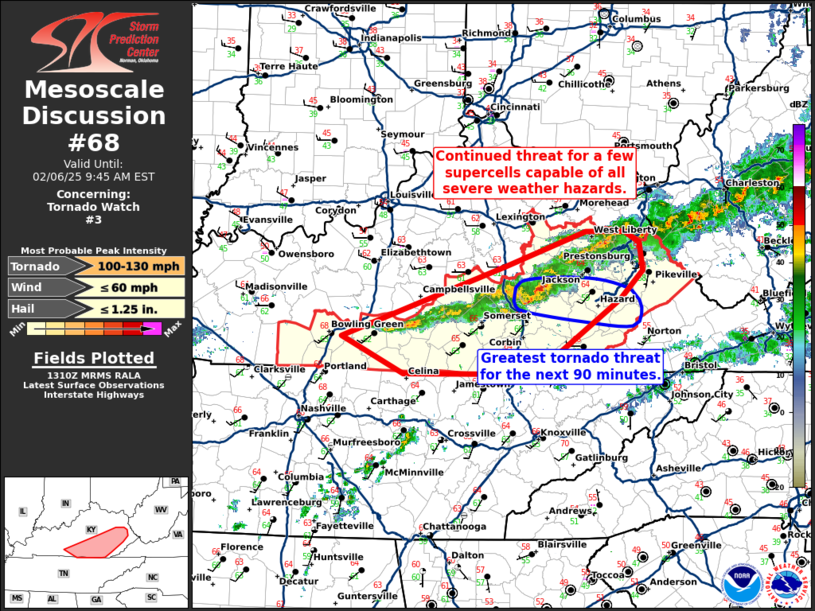
Areas affected...southern and eastern Kentucky
Concerning...Tornado Watch 3...
Valid 061312Z - 061445Z
The severe weather threat for Tornado Watch 3 continues.
SUMMARY...A threat for a few supercells capable of all severe
weather hazards continues.
DISCUSSION...The line of storms earlier this morning across central
Kentucky has become less defined through time with a few more
dominant supercells in a now broken line from east-central Kentucky
to south-central Kentucky. The strongest of these supercells is
moving through Jackson County as of 13Z with a somewhat tight 40
knot vRot sampled by the KJKL WSR-88D. Instability has already
started to wane across the region which should eventually weaken
these storms. However, in the meantime, a tornado threat may persist
given the presence of a mature, long-lived, rotating updraft amid
strong low-level shear (200 to 250 m2/s2 0-1km SRH). Per
collaboration with WFO JKL, tornado watch 3 has been expanded across
all of eastern Kentucky to cover the threat from these ongoing
storms.
..Bentley/Mosier.. 02/06/2025
...Please see www.spc.noaa.gov for graphic product...
ATTN...WFO...RLX...MRX...JKL...LMK...OHX...
LAT...LON 36948629 37648429 37978332 37968285 37858267 37598263
37308292 36828361 36618395 36598420 36598554 36948629
|
|
Top/All Mesoscale Discussions/Forecast Products/Home
|
|


 @NWSSPC