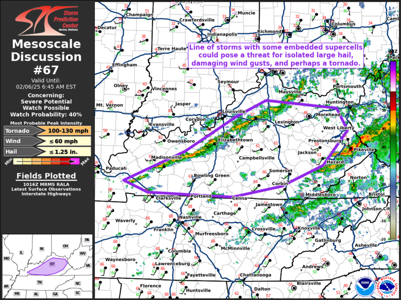
   Mesoscale Discussion 0067
   NWS Storm Prediction Center Norman OK
   0419 AM CST Thu Feb 06 2025

   Areas affected...Central Kentucky

   Concerning...Severe potential...Watch possible

   Valid 061019Z - 061145Z

   Probability of Watch Issuance...40 percent

   SUMMARY...A line of storms has developed across central Kentucky
   with a threat for isolated large hail, damaging wind gusts, and
   perhaps a tornado.

   DISCUSSION...A line of storms has developed along the cold front in
   central Kentucky this morning. Low 60s dewpoints and mid-60s
   temperatures ahead of the front are yielding an environment with
   around 1000 J/kg MUCAPE. Strong effective shear (~50 knots) will
   support occasional supercell structures from the stronger cells
   which develop within the line. In addition, low-level shear (300
   m2/s2 0-1km SRH per HPX VWP) will be favorable for some tornado
   potential with any stronger, organized supercell structures. In
   addition, a conditional strong tornado threat does exist if a
   strong, longer lasting, supercell can develop. Therefore, these
   stronger cells embedded within the line will need to be monitored
   through the morning for the threat for large hail, damaging wind
   gusts, and perhaps a tornado.

   The threat is expected to remain too isolated for a watch, but if a
   more widespread threat with multiple mature supercells develops, a
   watch may be needed.

   ..Bentley/Mosier.. 02/06/2025

   ...Please see www.spc.noaa.gov for graphic product...

   ATTN...WFO...RLX...JKL...ILN...LMK...PAH...

   LAT...LON   36938812 37538663 38238536 38538463 38368288 37928262
               37258325 36858427 36648546 36708754 36938812
|


 @NWSSPC