|
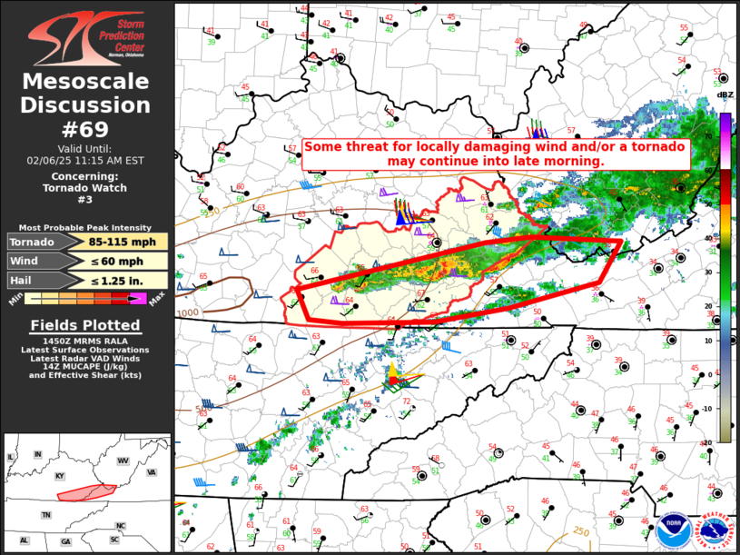
| Mesoscale Discussion 69 |
|
< Previous MD Next MD >
|
|
   Mesoscale Discussion 0069
   NWS Storm Prediction Center Norman OK
   0852 AM CST Thu Feb 06 2025

   Areas affected...Southeast KY into far western VA

   Concerning...Tornado Watch 3...

   Valid 061452Z - 061615Z

   The severe weather threat for Tornado Watch 3 continues.

   SUMMARY...Some threat for locally damaging wind and/or a tornado may
   continue into late morning.

   DISCUSSION...A band of thunderstorms with a history of producing an
   apparent tornado and locally damaging gusts is moving across
   southeast KY toward western VA this morning. Diminishing instability
   with eastward extent and a tendency for a weakening/veering
   low-level jet (as the primary midlevel shortwave trough moves away)
   should result in a gradual weakening trend with time as storms move
   eastward. However, strong low/midlevel flow and favorable deep-layer
   shear will continue to support organized convection through late
   morning, with an attendant threat of locally damaging gusts and
   perhaps a tornado across the remaining portion of WW 3, and also
   potentially into adjacent parts of far western VA.

   ..Dean.. 02/06/2025

   ...Please see www.spc.noaa.gov for graphic product...

   ATTN...WFO...RNK...RLX...MRX...JKL...

   LAT...LON   36948487 37388268 37438216 37398111 37008136 36788241
               36658328 36628434 36658474 36948487
|
|
Top/All Mesoscale Discussions/Forecast Products/Home
|
|


 @NWSSPC