Note:
The expiration time in the watch graphic is amended if the watch is
replaced, cancelled or extended.
Note:
Note:
The expiration time in the watch graphic is amended if the watch is
replaced, cancelled or extended.
Note: Click for
Watch Status Reports.
SEL3
URGENT - IMMEDIATE BROADCAST REQUESTED
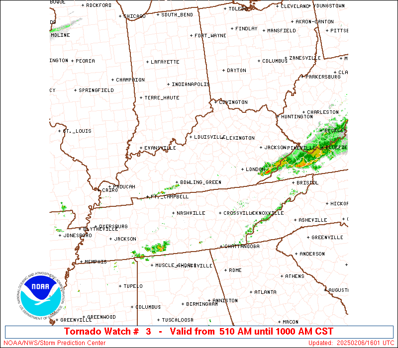
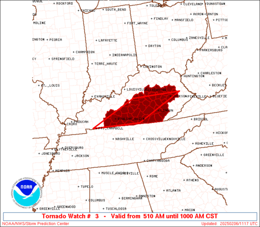
Tornado Watch Number 3
NWS Storm Prediction Center Norman OK
510 AM CST Thu Feb 6 2025
The NWS Storm Prediction Center has issued a
* Tornado Watch for portions of
Central Kentucky
* Effective this Thursday morning from 510 AM until 1000 AM CST.
* Primary threats include...
A couple tornadoes possible
Isolated damaging wind gusts to 70 mph possible
Isolated large hail events to 1 inch in diameter possible
SUMMARY...A line of thunderstorms is currently moving across central
Kentucky. This line has intensified over the past hour and
environmental conditions are expected to remain supportive of strong
to severe thunderstorms capable of producing brief tornadoes, strong
gusts, and isolated small hail.
The tornado watch area is approximately along and 70 statute miles
east and west of a line from 20 miles south of Bowling Green KY to
40 miles west northwest of Jackson KY. For a complete depiction of
the watch see the associated watch outline update (WOUS64 KWNS
WOU3).
PRECAUTIONARY/PREPAREDNESS ACTIONS...
REMEMBER...A Tornado Watch means conditions are favorable for
tornadoes and severe thunderstorms in and close to the watch
area. Persons in these areas should be on the lookout for
threatening weather conditions and listen for later statements
and possible warnings.
&&
AVIATION...Tornadoes and a few severe thunderstorms with hail
surface and aloft to 1 inch. Extreme turbulence and surface wind
gusts to 60 knots. A few cumulonimbi with maximum tops to 500. Mean
storm motion vector 27040.
...Mosier

   SEL3

   URGENT - IMMEDIATE BROADCAST REQUESTED
   Tornado Watch Number 3
   NWS Storm Prediction Center Norman OK
   510 AM CST Thu Feb 6 2025

   The NWS Storm Prediction Center has issued a

   * Tornado Watch for portions of
     Central Kentucky

   * Effective this Thursday morning from 510 AM until 1000 AM CST.

   * Primary threats include...
     A couple tornadoes possible
     Isolated damaging wind gusts to 70 mph possible
     Isolated large hail events to 1 inch in diameter possible

   SUMMARY...A line of thunderstorms is currently moving across central
   Kentucky. This line has intensified over the past hour and
   environmental conditions are expected to remain supportive of strong
   to severe thunderstorms capable of producing brief tornadoes, strong
   gusts, and isolated small hail.

   The tornado watch area is approximately along and 70 statute miles
   east and west of a line from 20 miles south of Bowling Green KY to
   40 miles west northwest of Jackson KY. For a complete depiction of
   the watch see the associated watch outline update (WOUS64 KWNS
   WOU3).

   PRECAUTIONARY/PREPAREDNESS ACTIONS...

   REMEMBER...A Tornado Watch means conditions are favorable for
   tornadoes and severe thunderstorms in and close to the watch
   area. Persons in these areas should be on the lookout for
   threatening weather conditions and listen for later statements
   and possible warnings.

   &&

   AVIATION...Tornadoes and a few severe thunderstorms with hail
   surface and aloft to 1 inch. Extreme turbulence and surface wind
   gusts to 60 knots. A few cumulonimbi with maximum tops to 500. Mean
   storm motion vector 27040.

   ...Mosier
 Note:
The Aviation Watch (SAW) product is an approximation to the watch area.
The actual watch is depicted by the shaded areas.
Note:
The Aviation Watch (SAW) product is an approximation to the watch area.
The actual watch is depicted by the shaded areas.
   SAW3
   WW 3 TORNADO KY 061110Z - 061600Z
   AXIS..70 STATUTE MILES EAST AND WEST OF LINE..
   20S BWG/BOWLING GREEN KY/ - 40WNW JKL/JACKSON KY/
   ..AVIATION COORDS.. 60NM E/W /15S BWG - 44N LOZ/
   HAIL SURFACE AND ALOFT..1 INCH. WIND GUSTS..60 KNOTS.
   MAX TOPS TO 500. MEAN STORM MOTION VECTOR 27040.

   LAT...LON 36668768 37758534 37758278 36668516

   THIS IS AN APPROXIMATION TO THE WATCH AREA.  FOR A
   COMPLETE DEPICTION OF THE WATCH SEE WOUS64 KWNS
   FOR WOU3.
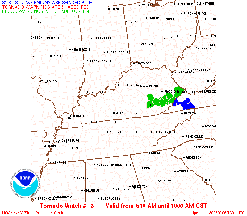
Watch 3 Status Report Messages:
STATUS REPORT #3 ON WW 3
VALID 061510Z - 061640Z
SEVERE WEATHER THREAT CONTINUES RIGHT OF A LINE FROM 45 NNW CSV
TO 10 WNW LOZ TO 50 ESE JKL TO 45 WNW BLF.
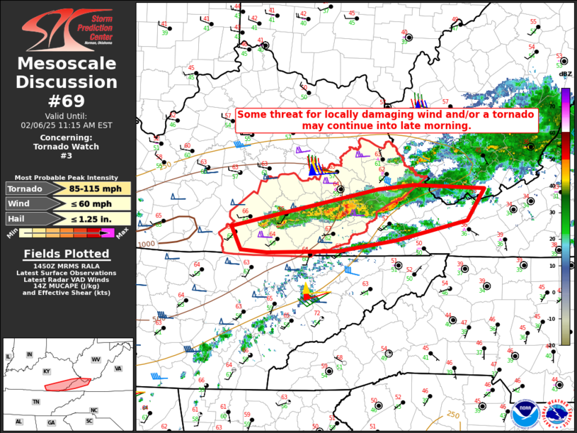
FOR ADDITIONAL INFORMATION SEE MESOSCALE DISCUSSION 69
..DEAN..02/06/25
ATTN...WFO...LMK...JKL...
&&
STATUS REPORT FOR WT 3
SEVERE WEATHER THREAT CONTINUES FOR THE FOLLOWING AREAS
KYC013-051-071-095-119-121-125-133-147-193-195-199-231-235-
061640-
KY
. KENTUCKY COUNTIES INCLUDED ARE
BELL CLAY FLOYD
HARLAN KNOTT KNOX
LAUREL LETCHER MCCREARY
PERRY PIKE PULASKI
WAYNE WHITLEY
$$
THE WATCH STATUS MESSAGE IS FOR GUIDANCE PURPOSES ONLY. PLEASE
REFER TO WATCH COUNTY NOTIFICATION STATEMENTS FOR OFFICIAL
INFORMATION ON COUNTIES...INDEPENDENT CITIES AND MARINE ZONES
CLEARED FROM SEVERE THUNDERSTORM AND TORNADO WATCHES.
$$
STATUS REPORT #2 ON WW 3
VALID 061340Z - 061440Z
SEVERE WEATHER THREAT CONTINUES RIGHT OF A LINE FROM 10 NW HOP TO
15 E BWG TO 25 NW LOZ TO 15 W JKL TO 35 SSW HTS.
..BENTLEY..02/06/25
ATTN...WFO...LMK...JKL...
&&
STATUS REPORT FOR WT 3
SEVERE WEATHER THREAT CONTINUES FOR THE FOLLOWING AREAS
KYC001-003-009-013-025-051-053-057-071-095-109-115-119-121-125-
133-141-147-153-159-169-171-189-193-195-199-203-207-213-227-231-
235-061440-
KY
. KENTUCKY COUNTIES INCLUDED ARE
ADAIR ALLEN BARREN
BELL BREATHITT CLAY
CLINTON CUMBERLAND FLOYD
HARLAN JACKSON JOHNSON
KNOTT KNOX LAUREL
LETCHER LOGAN MCCREARY
MAGOFFIN MARTIN METCALFE
MONROE OWSLEY PERRY
PIKE PULASKI ROCKCASTLE
RUSSELL SIMPSON WARREN
WAYNE WHITLEY
$$
THE WATCH STATUS MESSAGE IS FOR GUIDANCE PURPOSES ONLY. PLEASE
REFER TO WATCH COUNTY NOTIFICATION STATEMENTS FOR OFFICIAL
INFORMATION ON COUNTIES...INDEPENDENT CITIES AND MARINE ZONES
CLEARED FROM SEVERE THUNDERSTORM AND TORNADO WATCHES.
$$
STATUS REPORT #1 ON WW 3
VALID 061245Z - 061340Z
SEVERE WEATHER THREAT CONTINUES RIGHT OF A LINE FROM 30 NE HOP TO
15 NE BWG TO 20 SSE LEX TO 40 WSW HTS.
..BENTLEY..02/06/25
ATTN...WFO...LMK...JKL...
&&
STATUS REPORT FOR WT 3
SEVERE WEATHER THREAT CONTINUES FOR THE FOLLOWING AREAS
KYC001-003-009-025-031-045-051-053-057-061-065-079-087-099-109-
121-125-129-137-141-147-151-153-155-165-169-171-173-175-189-197-
199-203-207-213-217-227-231-235-237-061340-
KY
. KENTUCKY COUNTIES INCLUDED ARE
ADAIR ALLEN BARREN
BREATHITT BUTLER CASEY
CLAY CLINTON CUMBERLAND
EDMONSON ESTILL GARRARD
GREEN HART JACKSON
KNOX LAUREL LEE
LINCOLN LOGAN MCCREARY
MADISON MAGOFFIN MARION
MENIFEE METCALFE MONROE
MONTGOMERY MORGAN OWSLEY
POWELL PULASKI ROCKCASTLE
RUSSELL SIMPSON TAYLOR
WARREN WAYNE WHITLEY
WOLFE
$$
THE WATCH STATUS MESSAGE IS FOR GUIDANCE PURPOSES ONLY. PLEASE
REFER TO WATCH COUNTY NOTIFICATION STATEMENTS FOR OFFICIAL
INFORMATION ON COUNTIES...INDEPENDENT CITIES AND MARINE ZONES
CLEARED FROM SEVERE THUNDERSTORM AND TORNADO WATCHES.
$$
Note:
Click for Complete Product Text.
Tornadoes
Probability of 2 or more tornadoes
|
Mod (40%)
|
Probability of 1 or more strong (EF2-EF5) tornadoes
|
Low (10%)
|
Wind
Probability of 10 or more severe wind events
|
Low (20%)
|
Probability of 1 or more wind events > 65 knots
|
Low (10%)
|
Hail
Probability of 10 or more severe hail events
|
Low (20%)
|
Probability of 1 or more hailstones > 2 inches
|
Low (10%)
|
Combined Severe Hail/Wind
Probability of 6 or more combined severe hail/wind events
|
Mod (50%)
|
For each watch, probabilities for particular events inside the watch
(listed above in each table) are determined by the issuing forecaster.
The "Low" category contains probability values ranging from less than 2%
to 20% (EF2-EF5 tornadoes), less than 5% to 20% (all other probabilities),
"Moderate" from 30% to 60%, and "High" from 70% to greater than 95%.
High values are bolded and lighter in color to provide awareness of
an increased threat for a particular event.


 @NWSSPC