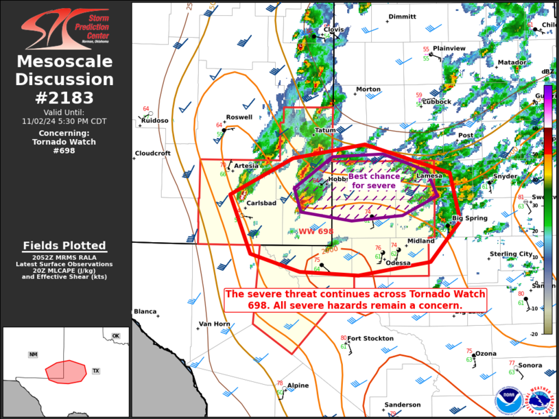
   Mesoscale Discussion 2183
   NWS Storm Prediction Center Norman OK
   0355 PM CDT Sat Nov 02 2024

   Areas affected...portions of west Texas into extreme southeastern
   New Mexico

   Concerning...Tornado Watch 698...

   Valid 022055Z - 022230Z

   The severe weather threat for Tornado Watch 698 continues.

   SUMMARY...The severe threat continues across Tornado Watch 698.
   Severe hail and wind appear to be the main threats, though a couple
   of tornadoes may still occur.

   DISCUSSION...Multiple supercells are in progress across extreme
   southeastern NM, with additional storms attempting to strengthen in
   far western TX near convective outflow remnant from an earlier
   squall line. MRMS mosaic MESH data suggests that severe hail may be
   falling with some of the more mature supercells, and a couple of
   stones may be approaching 2 inches in diameter. These storms are
   maximizing in intensity along a stalled convective outflow boundary,
   which is where the greatest threat for severe storms (including a
   tornado or two) remains. Farther south into the warm sector, the
   initiation of robust storms remains uncertain. Here, ample buoyancy
   remains in place, but visible satellite shows a stagnant, or
   potentially decaying cumulus field. Still, the severe threat should
   persist near the outflow boundary, where lift is strongest for
   supporting further storm development and potential upscale growth
   into a squall line later this evening.

   ..Squitieri.. 11/02/2024

   ...Please see www.spc.noaa.gov for graphic product...

   ATTN...WFO...LUB...MAF...

   LAT...LON   32560442 32990359 33150261 32820148 32260134 31800175
               31650270 31690349 31890414 32560442
|


 @NWSSPC