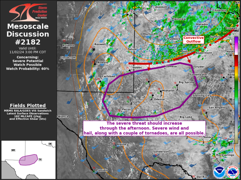
   Mesoscale Discussion 2182
   NWS Storm Prediction Center Norman OK
   0124 PM CDT Sat Nov 02 2024

   Areas affected...portions of west Texas into extreme southeastern
   New Mexico

   Concerning...Severe potential...Watch possible

   Valid 021824Z - 022000Z

   Probability of Watch Issuance...60 percent

   SUMMARY...The severe threat should gradually increase through the
   afternoon, with all severe hazards possible. A WW issuance may be
   needed in the next couple of hours pending robust storm
   intensification.

   DISCUSSION...Convection is gradually deepening across the Permian
   Basin amid a destabilizing boundary layer, with NLDN data depicting
   lightning already occurring with the deeper updrafts. 17Z
   mesoanalysis shows some remaining MLCINH in place. However, surface
   temperatures are approaching 80 F in spots, amid 60 F dewpoints,
   yielding 1500+ J/kg MLCAPE. Vertical wind profiles gradually veer
   from southeasterly at the surface, to southwesterly at 500 mb, with
   considerable strengthening with height noted in forecast soundings.
   Hodographs are relatively straight and elongated in the near-term,
   supporting 25-35 kts of effective bulk shear. However, strengthening
   low-level flow later this afternoon and evening will contribute to
   50+ kts of effective bulk shear and larger, curved low-level
   hodographs.

   As such, multicells and transient supercells should develop over the
   next couple of hours, though more sustained supercells may
   materialize by mid to late afternoon. The more intense, long-lived
   storms may produce severe gusts and large hail (with some stones
   potentially exceeding 2 inches in diameter). Low-level shear may
   also become strong enough to support the risk for a couple of
   tornadoes later this afternoon into early evening, when hodographs
   enlarge.

   ..Squitieri/Smith.. 11/02/2024

   ...Please see www.spc.noaa.gov for graphic product...

   ATTN...WFO...SJT...MAF...

   LAT...LON   31730415 32240395 32500357 32640296 32770210 32900140
               32810099 32150078 31550141 31290224 31240294 31240347
               31280390 31730415
|


 @NWSSPC