|
| Mesoscale Discussion 2184 |
|
< Previous MD Next MD >
|
|
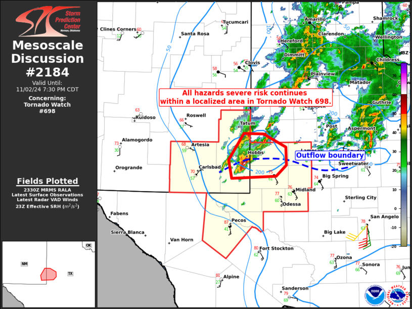
   Mesoscale Discussion 2184
   NWS Storm Prediction Center Norman OK
   0633 PM CDT Sat Nov 02 2024

   Areas affected...Southeast New Mexico into the southern Permian
   Basin

   Concerning...Tornado Watch 698...

   Valid 022333Z - 030030Z

   The severe weather threat for Tornado Watch 698 continues.

   SUMMARY...The severe risk remains confined to a small area in the
   northern portion of Tornado Watch 698.

   DISCUSSION...The threat of a brief tornado, large hail, and locally
   severe gusts generally remains confined to Lea, Andrews, and Gaines
   Counties within Tornado Watch 698. Here, backed surface winds (along
   the composite outflow boundary) beneath veering/strengthening winds
   with height are contributing to ample clockwise hodograph curvature
   (per nearby VWP data and mesoanalysis). This enhanced helicity and
   focused mesoscale ascent is favoring the maintenance of a discrete
   surface-based supercell capable of producing additional brief
   tornadoes, large hail, and locally damaging gusts. A couple
   semi-discrete cells to the north of the outflow boundary will also
   pose a localized severe risk, mainly in the form of marginally
   severe hail.

   ..Weinman.. 11/02/2024

   ...Please see www.spc.noaa.gov for graphic product...

   ATTN...WFO...LUB...MAF...

   LAT...LON   32530224 32320248 32270346 32630353 33130319 33110276
               32860225 32530224
|
|
Top/All Mesoscale Discussions/Forecast Products/Home
|
|


 @NWSSPC