 Note:
The expiration time in the watch graphic is amended if the watch is
replaced, cancelled or extended.
Note:
Note:
The expiration time in the watch graphic is amended if the watch is
replaced, cancelled or extended.
Note: Click for
Watch Status Reports.
SEL8
URGENT - IMMEDIATE BROADCAST REQUESTED
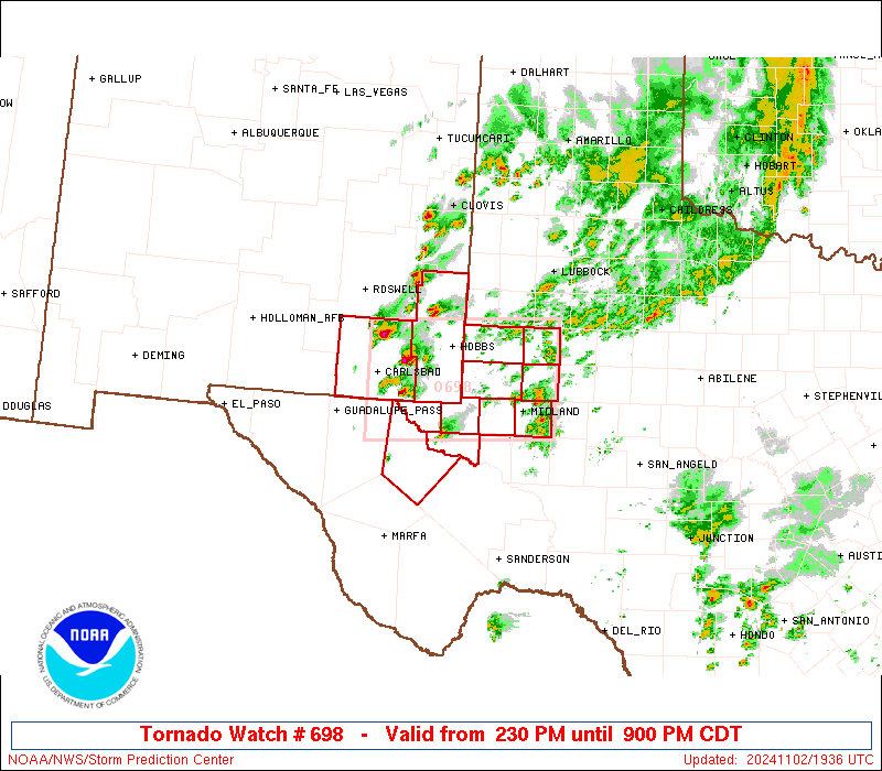
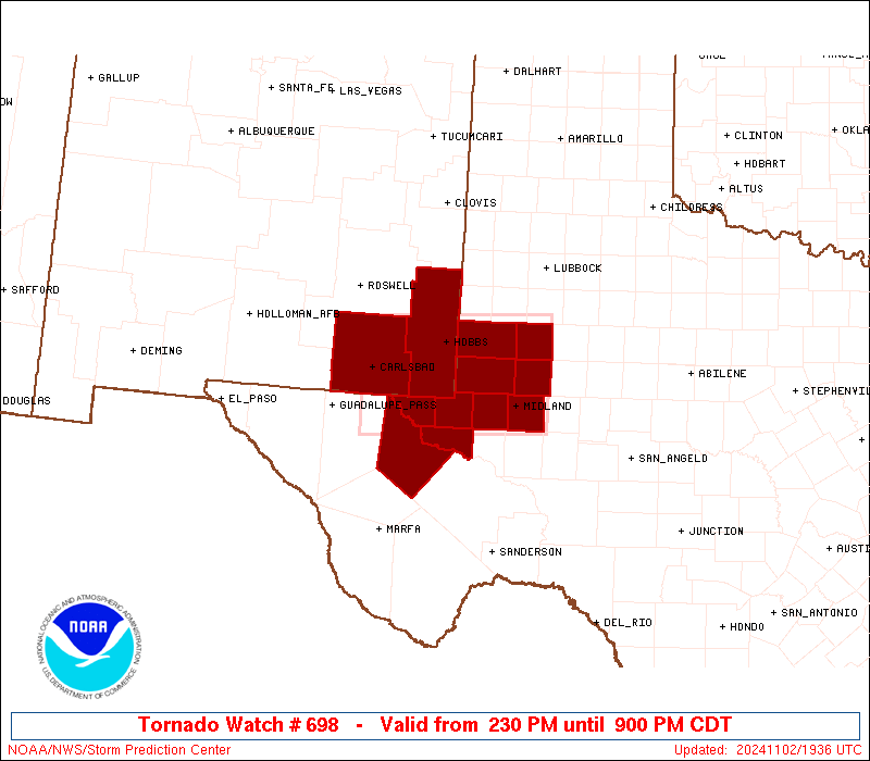
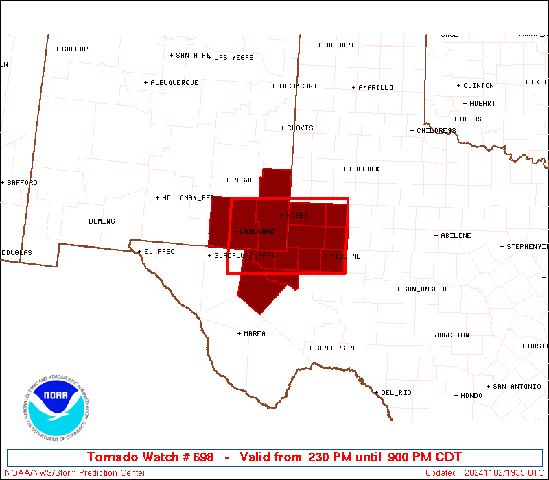
Tornado Watch Number 698
NWS Storm Prediction Center Norman OK
230 PM CDT Sat Nov 2 2024
The NWS Storm Prediction Center has issued a
* Tornado Watch for portions of
Southeast New Mexico
West Texas
* Effective this Saturday afternoon and evening from 230 PM until
900 PM CDT.
* Primary threats include...
A couple tornadoes possible
Scattered large hail and isolated very large hail events to 2.5
inches in diameter possible
Isolated damaging wind gusts to 70 mph possible
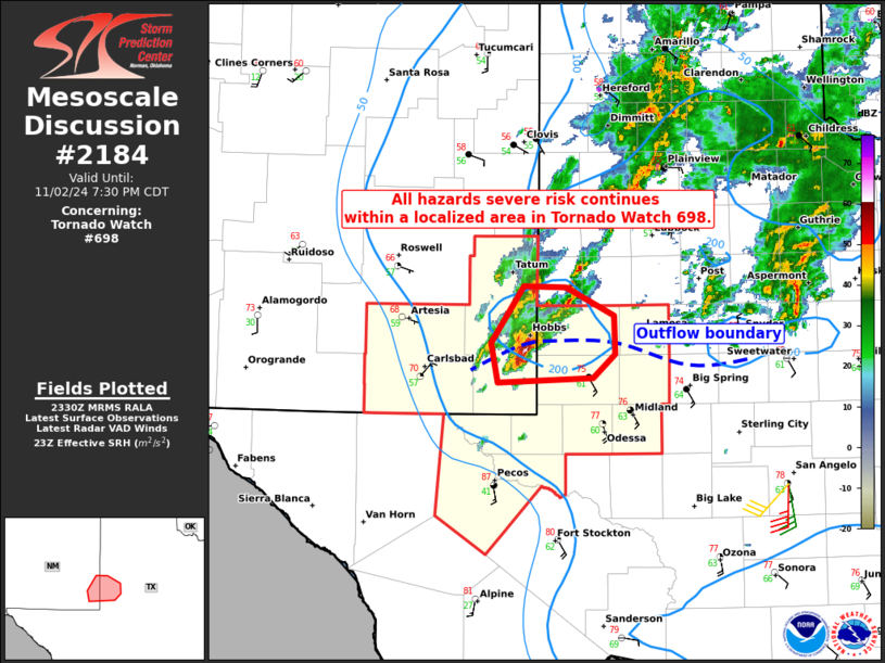
SUMMARY...Isolated to scattered severe thunderstorms are forecast
this afternoon into the evening across the Permian Basin. A few
supercells capable of large to very large hail (1 to 2.5 inches in
diameter) and severe gusts (60-70 mph) are expected. As the
low-level winds strengthen late this afternoon into the early
evening, a risk for a couple of tornadoes may develop with the more
intense supercells to the south of and immediately near an outflow
boundary draped from west to east across the area. Storms will
likely grow upscale into one or more small clusters later this
evening with severe wind and hail becoming the primary hazards.
The tornado watch area is approximately along and 50 statute miles
north and south of a line from 10 miles southwest of Carlsbad NM to
40 miles northeast of Midland TX. For a complete depiction of the
watch see the associated watch outline update (WOUS64 KWNS WOU8).
PRECAUTIONARY/PREPAREDNESS ACTIONS...
REMEMBER...A Tornado Watch means conditions are favorable for
tornadoes and severe thunderstorms in and close to the watch
area. Persons in these areas should be on the lookout for
threatening weather conditions and listen for later statements
and possible warnings.
&&
AVIATION...Tornadoes and a few severe thunderstorms with hail
surface and aloft to 2.5 inches. Extreme turbulence and surface wind
gusts to 60 knots. A few cumulonimbi with maximum tops to 500. Mean
storm motion vector 23025.
...Smith

   SEL8

   URGENT - IMMEDIATE BROADCAST REQUESTED
   Tornado Watch Number 698
   NWS Storm Prediction Center Norman OK
   230 PM CDT Sat Nov 2 2024

   The NWS Storm Prediction Center has issued a

   * Tornado Watch for portions of
     Southeast New Mexico
     West Texas

   * Effective this Saturday afternoon and evening from 230 PM until
     900 PM CDT.

   * Primary threats include...
     A couple tornadoes possible
     Scattered large hail and isolated very large hail events to 2.5
       inches in diameter possible
     Isolated damaging wind gusts to 70 mph possible

   SUMMARY...Isolated to scattered severe thunderstorms are forecast
   this afternoon into the evening across the Permian Basin.  A few
   supercells capable of large to very large hail (1 to 2.5 inches in
   diameter) and severe gusts (60-70 mph) are expected.  As the
   low-level winds strengthen late this afternoon into the early
   evening, a risk for a couple of tornadoes may develop with the more
   intense supercells to the south of and immediately near an outflow
   boundary draped from west to east across the area.  Storms will
   likely grow upscale into one or more small clusters later this
   evening with severe wind and hail becoming the primary hazards.

   The tornado watch area is approximately along and 50 statute miles
   north and south of a line from 10 miles southwest of Carlsbad NM to
   40 miles northeast of Midland TX. For a complete depiction of the
   watch see the associated watch outline update (WOUS64 KWNS WOU8).

   PRECAUTIONARY/PREPAREDNESS ACTIONS...

   REMEMBER...A Tornado Watch means conditions are favorable for
   tornadoes and severe thunderstorms in and close to the watch
   area. Persons in these areas should be on the lookout for
   threatening weather conditions and listen for later statements
   and possible warnings.

   &&

   AVIATION...Tornadoes and a few severe thunderstorms with hail
   surface and aloft to 2.5 inches. Extreme turbulence and surface wind
   gusts to 60 knots. A few cumulonimbi with maximum tops to 500. Mean
   storm motion vector 23025.

   ...Smith
 Note:
The Aviation Watch (SAW) product is an approximation to the watch area.
The actual watch is depicted by the shaded areas.
Note:
The Aviation Watch (SAW) product is an approximation to the watch area.
The actual watch is depicted by the shaded areas.
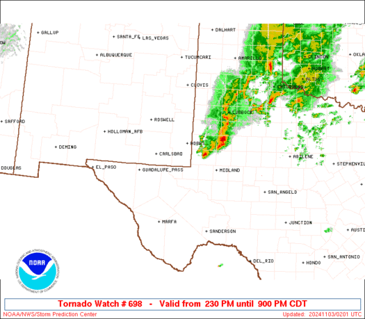
   SAW8
   WW 698 TORNADO NM TX 021930Z - 030200Z
   AXIS..50 STATUTE MILES NORTH AND SOUTH OF LINE..
   10SW CNM/CARLSBAD NM/ - 40NE MAF/MIDLAND TX/
   ..AVIATION COORDS.. 45NM N/S /62WNW INK - 31NE MAF/
   HAIL SURFACE AND ALOFT..2.5 INCHES. WIND GUSTS..60 KNOTS.
   MAX TOPS TO 500. MEAN STORM MOTION VECTOR 23025.

   LAT...LON 32950439 33080172 31630172 31500439

   THIS IS AN APPROXIMATION TO THE WATCH AREA.  FOR A
   COMPLETE DEPICTION OF THE WATCH SEE WOUS64 KWNS
   FOR WOU8.
Watch 698 Status Report Messages:
STATUS REPORT #3 ON WW 698

VALID 030045Z - 030140Z

SEVERE WEATHER THREAT CONTINUES RIGHT OF A LINE FROM 55 N MRF TO
55 SSE CVS.

..WEINMAN..11/03/24

ATTN...WFO...MAF...

&&

STATUS REPORT FOR WT 698

SEVERE WEATHER THREAT CONTINUES FOR THE FOLLOWING AREAS

TXC003-115-135-165-301-317-329-389-475-495-030140-

TX
.    TEXAS COUNTIES INCLUDED ARE

ANDREWS 	     DAWSON		 ECTOR
GAINES		     LOVING		 MARTIN
MIDLAND 	     REEVES		 WARD
WINKLER
$$


THE WATCH STATUS MESSAGE IS FOR GUIDANCE PURPOSES ONLY.  PLEASE
REFER TO WATCH COUNTY NOTIFICATION STATEMENTS FOR OFFICIAL
INFORMATION ON COUNTIES...INDEPENDENT CITIES AND MARINE ZONES
CLEARED FROM SEVERE THUNDERSTORM AND TORNADO WATCHES.
$$

STATUS REPORT #2 ON WW 698

VALID 022345Z - 030040Z

SEVERE WEATHER THREAT CONTINUES RIGHT OF A LINE FROM 55 NNW MRF
TO 50 S CVS.

FOR ADDITIONAL INFORMATION SEE MESOSCALE DISCUSSION 2184

..WEINMAN..11/02/24

ATTN...WFO...MAF...

&&

STATUS REPORT FOR WT 698

SEVERE WEATHER THREAT CONTINUES FOR THE FOLLOWING AREAS

NMC025-030040-

NM
.    NEW MEXICO COUNTIES INCLUDED ARE

LEA
$$


TXC003-115-135-165-301-317-329-389-475-495-030040-

TX
.    TEXAS COUNTIES INCLUDED ARE

ANDREWS 	     DAWSON		 ECTOR
GAINES		     LOVING		 MARTIN
MIDLAND 	     REEVES		 WARD
WINKLER
$$


THE WATCH STATUS MESSAGE IS FOR GUIDANCE PURPOSES ONLY.  PLEASE
REFER TO WATCH COUNTY NOTIFICATION STATEMENTS FOR OFFICIAL
INFORMATION ON COUNTIES...INDEPENDENT CITIES AND MARINE ZONES
CLEARED FROM SEVERE THUNDERSTORM AND TORNADO WATCHES.
$$

STATUS REPORT #1 ON WW 698

VALID 022230Z - 022340Z

THE SEVERE WEATHER THREAT CONTINUES ACROSS THE ENTIRE WATCH AREA.

..SPC..11/02/24

ATTN...WFO...MAF...

&&

STATUS REPORT FOR WT 698

SEVERE WEATHER THREAT CONTINUES FOR THE FOLLOWING AREAS

NMC015-025-022340-

NM
.    NEW MEXICO COUNTIES INCLUDED ARE

EDDY		     LEA
$$


TXC003-115-135-165-301-317-329-389-475-495-022340-

TX
.    TEXAS COUNTIES INCLUDED ARE

ANDREWS 	     DAWSON		 ECTOR
GAINES		     LOVING		 MARTIN
MIDLAND 	     REEVES		 WARD
WINKLER
$$


THE WATCH STATUS MESSAGE IS FOR GUIDANCE PURPOSES ONLY.  PLEASE
REFER TO WATCH COUNTY NOTIFICATION STATEMENTS FOR OFFICIAL
INFORMATION ON COUNTIES...INDEPENDENT CITIES AND MARINE ZONES
CLEARED FROM SEVERE THUNDERSTORM AND TORNADO WATCHES.
$$
Note:
Click for Complete Product Text.
Tornadoes
Probability of 2 or more tornadoes
|
Mod (40%)
|
Probability of 1 or more strong (EF2-EF5) tornadoes
|
Low (20%)
|
Wind
Probability of 10 or more severe wind events
|
Mod (30%)
|
Probability of 1 or more wind events > 65 knots
|
Low (20%)
|
Hail
Probability of 10 or more severe hail events
|
Mod (40%)
|
Probability of 1 or more hailstones > 2 inches
|
Mod (40%)
|
Combined Severe Hail/Wind
Probability of 6 or more combined severe hail/wind events
|
High (70%)
|
For each watch, probabilities for particular events inside the watch
(listed above in each table) are determined by the issuing forecaster.
The "Low" category contains probability values ranging from less than 2%
to 20% (EF2-EF5 tornadoes), less than 5% to 20% (all other probabilities),
"Moderate" from 30% to 60%, and "High" from 70% to greater than 95%.
High values are bolded and lighter in color to provide awareness of
an increased threat for a particular event.


 @NWSSPC