|
| Mesoscale Discussion 2125 |
|
< Previous MD Next MD >
|
|
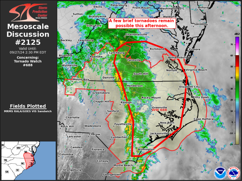
   Mesoscale Discussion 2125
   NWS Storm Prediction Center Norman OK
   1133 AM CDT Fri Sep 27 2024

   Areas affected...eastern NC and southern VA

   Concerning...Tornado Watch 688...

   Valid 271633Z - 271830Z

   The severe weather threat for Tornado Watch 688 continues.

   SUMMARY...A few brief tornadoes remain possible through the rest of
   the afternoon as a weakening band of showers with embedded
   thunderstorms moves across parts of eastern North Carolina and
   southern Virginia.

   DISCUSSION...Despite numerous low-level mesocyclones during the late
   morning to midday, tornadogenesis has largely appeared elusive
   within a persistent band of convection from the central NC/VA border
   area southward into coastal far southern NC. One strong meso with
   the deepest updraft last hour may have briefly produced in southern
   NC per an ILM LSR. Low-level winds have subsided across the coastal
   plain via LTX VWP data, but do remain sufficient for a brief tornado
   threat amid 74-78 F surface dew points and temperatures in the low
   80s. Farther north, low-level hodographs remain rather enlarged, but
   will shrink throughout the afternoon. Morning CAM guidance suggest a
   breakup to the convective band should occur, which will yield a more
   cellular mode. This would favor potential for a few tornadoes, but
   should be tempered by the otherwise diminishing shear/ascent
   environment.

   ..Grams.. 09/27/2024

   ...Please see www.spc.noaa.gov for graphic product...

   ATTN...WFO...AKQ...MHX...LWX...RAH...ILM...RNK...

   LAT...LON   36577861 37157890 37617879 37827839 37877761 37627677
               37267624 36667590 35907601 35007620 34257735 34067779
               34077814 35217808 36577861
|
|
Top/All Mesoscale Discussions/Forecast Products/Home
|
|


 @NWSSPC